
- 91.6LEGITIMACY SCORE
- 92.1SAFETY SCORE
- 12+CONTENT RATING
- $8.99PRICE
What is Nautical Charts & Maps? Description of Nautical Charts & Maps 1206 chars
Main Features Include:
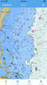
+ NOAA Electronic Navigational Charts (ENC)
+ NOAA Weather Map Overlays
-- ELECTRONIC NAVIGATION CHARTS --
Electronic Navigational Charts (ENC) are vector data sets that support all types of marine navigation.
+ All charts are available to download for offline use
+ Chart format options include: NOAA, ECDIS
ENC charts display the following information:
+ Buoys, Beacons, Lights, Fog Signals, Radar
+ Natural and Man-Made Features
+ Services and Small Craft Facilities
+ Seabed, Obstructions, Pipelines
+ Depths, Currents
+ Port Features
+ Traffic Routes
+ Special areas
NOAA updates the ENCs for Notice to Mariners on a weekly basis. Timing of their availability is not guaranteed.
The ENC charts displayed in this app does NOT meet federal chart carriage regulations for regulated vessels.
Users should consult the Code of Federal Regulations for current federal chart carriage requirements.
-- NOAA WEATHER MAP OVERLAYS --
+ Weather Radar
+ Sea Surface Temperature
+ Significant Wave Height
+ Wind Speed & Direction
+ 12-Hour Rain Probability
+ Lightning Strike Density
+ Air Temperature
If you have any questions, please email [email protected]
- Nautical Charts & Maps App User Reviews
- Nautical Charts & Maps Pros
- Nautical Charts & Maps Cons
- Is Nautical Charts & Maps legit?
- Should I download Nautical Charts & Maps?
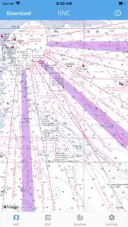
- Nautical Charts & Maps Screenshots
- Product details of Nautical Charts & Maps
Nautical Charts & Maps App User Reviews
What do you think about Nautical Charts & Maps app? Ask the appsupports.co community a question about Nautical Charts & Maps!
Please wait! Facebook Nautical Charts & Maps app comments loading...
Nautical Charts & Maps Pros
✓ Do not waste your moneyI was looking for an app that gave me information on North American lakes. Thinking NOAA was the best of the best, I download the app and wasted money once AGAIN. COMPLETE WAIST OF MONEY..Version: 1.1.4
✓ SimpleSimple chart program. Puts you on a Noaa chart. Lacks tools were accustomed to. Great value though. I’m hoping the developer will add a few tools. I’d gladly pay more if they’d add marks routing and a caliper tool. Keep it simple though. I payed 50 bucks for the original Navionics. Was really happy to do so. Now that they’ve gotten greedy and made it a ridiculous subscription I’m out. This app and its potential are a breath of fresh air..Version: 1.6
✓ Nautical Charts & Maps Positive ReviewsNautical Charts & Maps Cons
✗ Just mapsNo location info or ability to save a location. Should have researched it better before buying. Waste of 9 bucks.Version: 1.1.4
✗ It’s good but…It’s good but for some reason you can’t download most maps They have a very small selection for offline use NOAA has them all for free I was just trying to find something to display but this isn’t it Anyways if in service it does seem like it uses raster well.Version: 1.1.12
✗ Nautical Charts & Maps Negative ReviewsIs Nautical Charts & Maps legit?
✅ Yes. Nautical Charts & Maps is 100% legit to us. This conclusion was arrived at by running over 3,492 Nautical Charts & Maps user reviews through our NLP machine learning process to determine if users believe the app is legitimate or not. Based on this, AppSupports Legitimacy Score for Nautical Charts & Maps is 91.6/100.
Is Nautical Charts & Maps safe?
✅ Yes. Nautical Charts & Maps is quiet safe to use. This is based on our NLP analysis of over 3,492 user reviews sourced from the IOS appstore and the appstore cumulative rating of 4.6/5. AppSupports Safety Score for Nautical Charts & Maps is 92.1/100.
Should I download Nautical Charts & Maps?
✅ There have been no security reports that makes Nautical Charts & Maps a dangerous app to use on your smartphone right now.
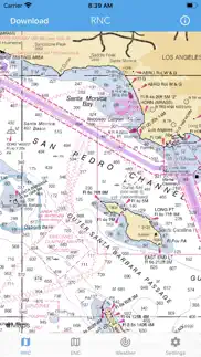
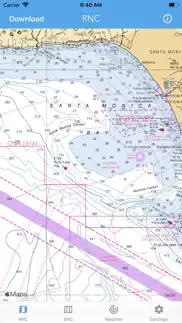
Nautical Charts & Maps Screenshots
Product details of Nautical Charts & Maps
- App Name:
- Nautical Charts & Maps
- App Version:
- 1.11
- Developer:
- LW Brands, LLC
- Legitimacy Score:
- 91.6/100
- Safety Score:
- 92.1/100
- Content Rating:
- 12+ May contain content unsuitable for children under the age of 12!
- Category:
- Navigation, Weather
- Language:
- EN FR PT
- App Size:
- 14.30 MB
- Price:
- $8.99
- Bundle Id:
- lwbrands.nauticalcharts
- Relase Date:
- 06 August 2018, Monday
- Last Update:
- 19 February 2024, Monday - 23:38
- Compatibility:
- IOS 14.0 or later
+ Incorporated the latest NOAA ENC chart options + Fixed a few bugs Thank you for the positive feedback!.