
- 88.8LEGITIMACY SCORE
- 91.3SAFETY SCORE
- 4+CONTENT RATING
- FreePRICE
What is Rivercast - Levels & Forecasts? Description of Rivercast - Levels & Forecasts 4033 chars
Rivercast™ puts the river level data you need at your fingertips with its intuitive and interactive maps and graphs.
With Rivercast™ you get:
• Official Flood Warnings & other alerts from the National Weather Service
• River stage height in Feet
• River flow rate in CFS (when available)
• Indications that a river is at or approaching flood stage
• Current observations and recent history
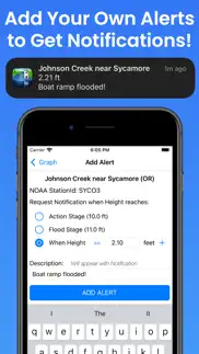
• Custom Push Notification Alerts for when river reaches levels of concern to you
• NOAA river forecasts (when available)
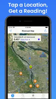
• Map interface that shows where river gauges are located geographically
• Search interface to find river gauges by waterway name, state, or NOAA 5 digit station ID
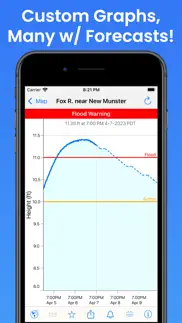
• Interactive graphs that you can zoom in, zoom out, or pan
• Customize your graphs by adding river levels that are relevant to you
• Favorites list for locations you care about the most
• Share your graphs via iMessage, Email, Facebook, or Twitter
• Home Screen and Desktop Widgets to monitor your favorites
• Lock Screen & StandBy Mode Widgets to monitor your favorites
Rivercast's map not only shows you where the stations are, but color codes them when it can to give you an indication whether the location is at normal levels, approaching flood levels, or above flood stage.
You can get the latest observations from the map, search, or favorites. With an additional tap of your finger you can get a detailed interactive hydrograph. You can zoom in, zoom out, or pan with your fingers to find the exact information you need. If you "tap and hold" on the graph you can view the crosshair "bubble" text to assist you further.
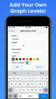
To customize your graphs for what's important to you, you can add your own level lines to mark things like sandbars, rocks, bridges, safe conditions, or whatever you would like.
And you can add the streams or rivers that you would like to regularly monitor to your Favorites list for easy "at a glance" viewing.
Rivercast™ uses the latest observation and forecast data available, and requires an Internet connection for use.
Favorites, Map "Instant Observations", and Hydrograph data is viewable in feet or cfs (when available).
All observation and forecast data is in your local time for your convenience.
A handy tool for boaters, fishermen, property owners, paddlers, scientists, marine professionals, and the curious.
River gauges reported are USA only.
* * * * * * * * * * * * * * * * * * * * * * *
Some Frequently Asked Questions:
Where does Rivercast™ get its data?
• This app uses NOAA and AHPS (Advanced Hydrologic Prediction Service) for its raw data for our custom graphing and mapping solutions. There are some locations that are available via other government agencies (including USGS) that are not available via this app.
Why does Rivercast™ sometimes show slightly different flow data (CFS) than USGS?
• CFS is a calculated estimate derived from stage height. NOAA and USGS estimates may sometimes slightly vary due to using different data models. Variances are usually within a few percent, but can sometimes be larger. Stage height should always be identical between USGS and NOAA. Designated flood stages are based on stage height in feet in the USA.
Why does Rivercast™ only show observations, but not forecasts, for my river?
• NOAA issues forecasts for many, but not all, rivers it monitors. Sometimes forecasts are only issued seasonally, or during times of flooding or high water.
My river gauge was there yesterday, but its gone today?
• River gauges have a hard life. They occasionally have technical problems transmitting their data, or can even get washed out during extreme flooding. And some are seasonal. NOAA is usually pretty good about fixing them in a few days.
For more information about Rivercast™, please visit our website at www.RivercastApp.com!
We take our accuracy seriously!
Terms of Use: https://www.apple.com/legal/internet-services/itunes/dev/stdeula/
- Rivercast - Levels & Forecasts App User Reviews
- Rivercast - Levels & Forecasts Pros
- Rivercast - Levels & Forecasts Cons
- Is Rivercast - Levels & Forecasts legit?
- Should I download Rivercast - Levels & Forecasts?
- Rivercast - Levels & Forecasts Screenshots
- Product details of Rivercast - Levels & Forecasts
Rivercast - Levels & Forecasts App User Reviews
What do you think about Rivercast - Levels & Forecasts app? Ask the appsupports.co community a question about Rivercast - Levels & Forecasts!
Please wait! Facebook Rivercast - Levels & Forecasts app comments loading...
Rivercast - Levels & Forecasts Pros
✓ Very usefulCheck this app everyday before headed out to the river. Never once have had any issues and the info is also accurate and up the date.Version: 3.43
✓ Great appWe live near a river. It is so helpful to be able to check river levels up the river and of course the river level near you. Easy to use. It helps you know if you will need to evacuate.Version: 3.46
✓ Rivercast - Levels & Forecasts Positive ReviewsRivercast - Levels & Forecasts Cons
✗ Waste Of MoneyPaid for premium to see forecasting of river at my cabin knowing a flood was coming. Premium gave me no additional data!!! Pretty bad when another free app included the forecasting data as provided online by the Advanced Hydrolic Prediction Service. Complete waste of $5 for me and a reason why we should be allowed to try apps before buying. UPDATE: This app developer took two weeks to respond with a lame blanket statement that provided no help. Another River app developer contacted me in days and worked with me via email to identify the issue with the missing data..Version: 3.46
✗ Not Worth the PriceThis app is basically highway robbery trying to charge 9$ a year for access to what is publicly available and free data. Do yourself a favor and just go to NOAA website directly through Safari and look up the waterway or dam you wish to get water level readings from and then just save that page as a bookmark to your Home Screen on your phone for future quick lookups. The data is 100% free and publicly available, and the NOAA website will show you graphs and future water level timelines in excess of a week out for FREE. Don’t let this app sucker you into paying extra each year to get more than 30 hours of data. The NOAA website itself is actually more robust and easier to read than this app, with more granular control over the FREE data available..Version: 4.11
✗ Rivercast - Levels & Forecasts Negative ReviewsIs Rivercast - Levels & Forecasts legit?
✅ Yes. Rivercast - Levels & Forecasts is 100% legit to us. This conclusion was arrived at by running over 9,211 Rivercast - Levels & Forecasts user reviews through our NLP machine learning process to determine if users believe the app is legitimate or not. Based on this, AppSupports Legitimacy Score for Rivercast - Levels & Forecasts is 88.8/100.
Is Rivercast - Levels & Forecasts safe?
✅ Yes. Rivercast - Levels & Forecasts is quiet safe to use. This is based on our NLP analysis of over 9,211 user reviews sourced from the IOS appstore and the appstore cumulative rating of 4.6/5. AppSupports Safety Score for Rivercast - Levels & Forecasts is 91.3/100.
Should I download Rivercast - Levels & Forecasts?
✅ There have been no security reports that makes Rivercast - Levels & Forecasts a dangerous app to use on your smartphone right now.
Rivercast - Levels & Forecasts Screenshots
Product details of Rivercast - Levels & Forecasts
- App Name:
- Rivercast - Levels & Forecasts
- App Version:
- 5.0
- Developer:
- Juggernaut Technology, Inc.
- Legitimacy Score:
- 88.8/100
- Safety Score:
- 91.3/100
- Content Rating:
- 4+ Contains no objectionable material!
- Category:
- Weather, Navigation
- Language:
- EN
- App Size:
- 17.85 MB
- Price:
- Free
- Bundle Id:
- com.juggernaut-tech.rivercast
- Relase Date:
- 17 November 2012, Saturday
- Last Update:
- 16 April 2024, Tuesday - 16:20
- Compatibility:
- IOS 15.0 or later
- Up to 30 days of observation data now available at most locations for Premium users! - Performance, stability, and usability enhancements..