
- 87.9LEGITIMACY SCORE
- 90.9SAFETY SCORE
- 4+CONTENT RATING
- $12.99PRICE
What is Wasatch Backcountry Skiing Map? Description of Wasatch Backcountry Skiing Map 1454 chars
The Wasatch Backcountry Skiing Map is the iOS version of the popular paper map and website (visit WBSkiing.com). As with the other platforms, the iOS map includes an index to more than 1,000 backcountry locations in Utah’s Central Wasatch mountains. It is the must-have app for Utah hikers and backcountry travelers.
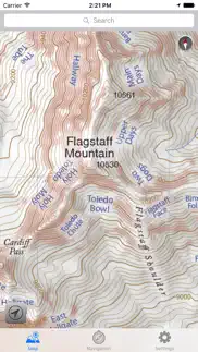
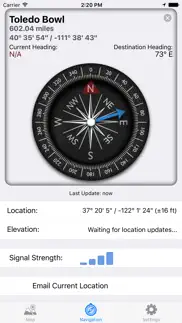
With a familiar map-app interface, the Wasatch Backcountry Skiing Map accesses your device’s GPS to display your current location on a high-resolution topo map. And with only a few taps, the “destination arrow” on the integrated compass will point to your desired backcountry ski location.
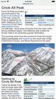
And with a single tap, hundreds of the locations will open the Wasatch Backcountry Skiing Guide website where you can view photographs and detailed information about the location.
The app also displays your current elevation and lat/long, and will send your current location via email. And with a tap, you can display detailed information on more than 200 of the locations including skiing difficulty, skinning distance, vertical climb, parking considerations, and more.
(Contrary to a posted review, you don't need cell service to use this app--you don't even need a contract with a cell service provider.)
NOTICES: When navigating, the “destination arrow” points directly to the destination without regard to hazards such as avalanche paths, cliffs, and rock fall. It is your responsibility to travel in the backcountry safely.
- Wasatch Backcountry Skiing Map App User Reviews
- Wasatch Backcountry Skiing Map Pros
- Wasatch Backcountry Skiing Map Cons
- Is Wasatch Backcountry Skiing Map legit?
- Should I download Wasatch Backcountry Skiing Map?
- Wasatch Backcountry Skiing Map Screenshots
- Product details of Wasatch Backcountry Skiing Map
Wasatch Backcountry Skiing Map App User Reviews
What do you think about Wasatch Backcountry Skiing Map app? Ask the appsupports.co community a question about Wasatch Backcountry Skiing Map!
Please wait! Facebook Wasatch Backcountry Skiing Map app comments loading...
Wasatch Backcountry Skiing Map Pros
✓ Amazing!An essential tool for our wonderful backcountry! Very detailed..Version: 3.0.1
✓ A Wasatch essentialSuper happy with this app, and we’ll worth the price. GPS location even when out of service is accurate, and the map is easy to navigate. Elevation is also accurate enough. As others have mentioned, it would be nice to be able to access (offline) info for a specific route that you’re doing that day. It would also be interesting to see an overlay of the route you took (or are supposed to take) for certain routes, although the argument could be made that this takes the learning out of route finding and navigation (fair). All in all, I love it! The extra features would be icing on the cake. I appreciate the work that went into this!.Version: 3.5.0
✓ Wasatch Backcountry Skiing Map Positive ReviewsWasatch Backcountry Skiing Map Cons
✗ Not worth $5This app isn't much more than a geo referenced Topo map. A very confined topo map of the central Wasatch. It does not show approach routes or descent lines. It has a searchable database of route names but not browsable. You'd have to know the name of the route ahead of time. And if you knew that, you probably have coordinates, pictures, route sketches etc. Save your money and find a free app that has a bigger map..Version: 3.0.1
✗ Wasatch?For that much money it would have been nice to get more of the wasatch mountain range not just the cottonwoods.Version: 3.5.0
✗ Wasatch Backcountry Skiing Map Negative ReviewsIs Wasatch Backcountry Skiing Map legit?
✅ Yes. Wasatch Backcountry Skiing Map is 100% legit to us. This conclusion was arrived at by running over 519 Wasatch Backcountry Skiing Map user reviews through our NLP machine learning process to determine if users believe the app is legitimate or not. Based on this, AppSupports Legitimacy Score for Wasatch Backcountry Skiing Map is 87.9/100.
Is Wasatch Backcountry Skiing Map safe?
✅ Yes. Wasatch Backcountry Skiing Map is quiet safe to use. This is based on our NLP analysis of over 519 user reviews sourced from the IOS appstore and the appstore cumulative rating of 4.6/5. AppSupports Safety Score for Wasatch Backcountry Skiing Map is 90.9/100.
Should I download Wasatch Backcountry Skiing Map?
✅ There have been no security reports that makes Wasatch Backcountry Skiing Map a dangerous app to use on your smartphone right now.
Wasatch Backcountry Skiing Map Screenshots
Product details of Wasatch Backcountry Skiing Map
- App Name:
- Wasatch Backcountry Skiing Map
- App Version:
- 3.5.0
- Developer:
- Iterum, LLC
- Legitimacy Score:
- 87.9/100
- Safety Score:
- 90.9/100
- Content Rating:
- 4+ Contains no objectionable material!
- Category:
- Navigation, Sports
- Language:
- EN
- App Size:
- 88.86 MB
- Price:
- $12.99
- Bundle Id:
- Iterum-LLC.WBSkiing
- Relase Date:
- 01 October 2013, Tuesday
- Last Update:
- 11 December 2017, Monday - 23:20
- Compatibility:
- IOS 8.0 or later
This app has been updated by Apple to display the Apple Watch app icon. Version 3.5.0 is now linked to the Wasatch Backcountry Skiing Guide. After selecting any of the hundreds of linked-locations in the app and tapping on the "Tap here for more .......