

- 61.1LEGITIMACY SCORE
- 65.6SAFETY SCORE
- 4+CONTENT RATING
- $4.99PRICE
What is Flood Maps & ZDs? Description of Flood Maps & ZDs 3429 chars
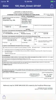
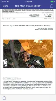
Create the Standard Flood Hazard Determination Form (SFHDF) right on your iPad and iPhone. This is more than what is available on the FEMA site; it automatically completes the SFHDF form including the Community and map panel information, and provides a map showing the property with the FEMA / NFIP overlay!
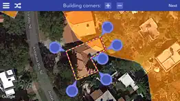
FLOOD ZONE quickly and easily gives you the FEMA designated flood zone of your current location or a point you choose on a map. Real estate agents, insurance agents, GIS professionals, surveyors, landowners and anyone with an interest in flood related products or services will find this app's subscription service easy, quick and very affordable.
Realtors and Real estate agents: Add value to the service you provide. Top agents are knowledgeable of flood zones. Areas with a significant risk of flooding can be located miles away from bodies of water or rivers, and lender-required flood insurance can put a reasonably priced home out of the reach of some buyers. Use FLOOD ZONE to identify these properties and save yourself and buyers time and frustration. Listing agents and sellers can benefit too. Purchasers need to know that increases in flood insurance premiums are affected by a property’s flood zone. The FLOOD ZONE app helps listing agents and sellers determine what they need to disclose when placing a home on the market.
Home Owners: FLOOD ZONE can help you monitor if your property’s flood zone has changed because of flood map redrawing. Are you near the boundary of two different zones? Use FLOOD ZONE to see how close you are to higher risk.
FLOOD ZONE shows FEMA approved flood hazard maps using National Flood Insurance Program data that is updated regularly. FLOOD ZONE is an informational tool and not a substitute for an elevation certificate performed by a qualified professional. Data is believed accurate but not guaranteed. This app is NOT an official NFIP or FEMA publication. Please refer to official FEMA and NFIP resources and appropriately qualified professionals for all related determinations.
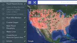
You can customize the map to hide or show FIRM Panels, Flood Hazard Zones, LOMRs, LOMAs, River Mile Markers, Coastal Gages, Base Flood Elevations, Water Lines, Coastal Barrier Resources System Area, and Levees.
The app REQUIRES an auto-renew subscription to the online flood zone maps, offered as an in-app purchase. The app comes with a free trial of access to the flood zone maps before you have to buy anything.
There is an OPTIONAL auto-renew subscription to create Flood Hazard Determination PDF documents, offered as an in-app purchase.
Discounts may be provided for longer subscription periods. Payment will be charged to your iTunes Account at confirmation of purchase. Subscription automatically renews unless auto-renew is turned off at least 24-hours before the end of the current period. Account will be charged for renewal within 24-hours prior to the end of the current period, and identify the cost of the renewal. Subscriptions may be managed by the user here: https://goo.gl/8gknaa
Subscription auto-renewal may be turned off by going to the user's Account Settings after purchase. No cancellation of the current subscription is allowed during active subscription period. Any unused portion of a free trial period, if offered, will be forfeited when the user purchases a subscription to that publication.
http://www.ikonetics.com/app-site-terms-privacy.html
- Flood Maps & ZDs App User Reviews
- Flood Maps & ZDs Pros
- Flood Maps & ZDs Cons
- Is Flood Maps & ZDs legit?
- Should I download Flood Maps & ZDs?
- Flood Maps & ZDs Screenshots
- Product details of Flood Maps & ZDs
Flood Maps & ZDs App User Reviews
What do you think about Flood Maps & ZDs app? Ask the appsupports.co community a question about Flood Maps & ZDs!
Please wait! Facebook Flood Maps & ZDs app comments loading...
Flood Maps & ZDs Pros
✓ Easier than FEMA websiteIf you need zone determinations this app is great and way better than the clunky fema site..Version: 6.7
✓ Easy to use and does the job!On my phone this app is easier to navigate than the FEMA site. The maps are clear and you can zoom in and show the structure in the zone. You need to know what you are looking at so that you can explain it to a property buyer, but all realtors should already know this..Version: 6.7
✓ Flood Maps & ZDs Positive ReviewsFlood Maps & ZDs Cons
✗ Useless. A waste of $10 plus Scription’sI’m purchasing property on the Sprague river in Oregon. From what I can tell on FEMA maps, it may be in FloodZone C. I tried searching with this app. All I get is “No FEMA Data” I’ve contacted support twice. No response I wasted $10 on app and another $10 on required subscriptions..Version: 6.2
✗ Additional fees, no fema data for my property. ScammySo…$5 for a moth of flood maps, but then another $3 a month for flood zone maps. Neither of which worked. I feel like I just got muggged..Version: 6.7
✗ Flood Maps & ZDs Negative ReviewsIs Flood Maps & ZDs legit?
✅ Yes. Flood Maps & ZDs is legit, but not 100% legit to us. This conclusion was arrived at by running over 199 Flood Maps & ZDs user reviews through our NLP machine learning process to determine if users believe the app is legitimate or not. Based on this, AppSupports Legitimacy Score for Flood Maps & ZDs is 61.1/100.
Is Flood Maps & ZDs safe?
✅ Yes. Flood Maps & ZDs is quiet safe to use. This is based on our NLP analysis of over 199 user reviews sourced from the IOS appstore and the appstore cumulative rating of 3.5/5. AppSupports Safety Score for Flood Maps & ZDs is 65.6/100.
Should I download Flood Maps & ZDs?
✅ There have been no security reports that makes Flood Maps & ZDs a dangerous app to use on your smartphone right now.
Flood Maps & ZDs Screenshots
Product details of Flood Maps & ZDs
- App Name:
- Flood Maps & ZDs
- App Version:
- 7.0
- Developer:
- Ikonetics
- Legitimacy Score:
- 61.1/100
- Safety Score:
- 65.6/100
- Content Rating:
- 4+ Contains no objectionable material!
- Language:
- EN
- App Size:
- 25.62 MB
- Price:
- $4.99
- Bundle Id:
- com.ikonetics.FloodZone
- Relase Date:
- 14 October 2014, Tuesday
- Last Update:
- 17 October 2023, Tuesday - 15:11
- Compatibility:
- IOS 16.0 or later
Updated maps, minor stability fixes..