


- 35.7LEGITIMACY SCORE
- 36.2SAFETY SCORE
- 4+CONTENT RATING
- $0.99PRICE
What is OFFROAD ATLAS? Description of OFFROAD ATLAS 3625 chars
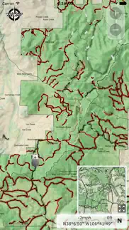
OFFROAD ATLAS allows you to safely explore our National Forest land, even offline. The app shows your GPS location on our seamless Motor Vehicle Use Map (MVUM) to help you identify roads, stay on trails, obey use classifications, and navigate alternative routes in and out of the forest. We also offer quick access to the official MVUM PDFs.
What is a MVUM? It is a map that shows where you can legally operate a motor vehicle on National Forest land. OFFROAD ATLAS uses your phone’s GPS to show your location on our seamless map. We combine the MVUM with other data such as local roads and our map is easily downloaded for offline use.
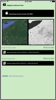
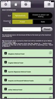
You may browse the map while you have wifi or cell service and OFFROAD ATLAS will automatically download any of the areas you view for offline use when you don't have network access. You may also bulk download any of the areas you plan on visiting.
Always have as much information as possible, please consult the published (printable) PDF Motor Vehicle Use Maps available for any individual forests you plan on visiting to get the latest dispersed camping allowances, seasonal closures, and any other relevant information. As always, be careful, many trails and roads are not suitable for passenger car travel. Some are only traversable in the most capable off road vehicles by the most experienced drivers.
Have fun, be safe, and respect the trails.
OFFROAD ATLAS makes no warranty, expressed or implied, including the warranties of merchantability and fitness for a particular purpose, nor assumes any legal liability or responsibility for the accuracy, reliability, completeness or utility of these geospatial data, or for the improper or incorrect use of these geospatial data. These geospatial data and related maps or graphics are not legal documents and are not intended to be used as such. The data and maps may not be used to determine title, ownership, legal descriptions or boundaries, legal jurisdiction, or restrictions that may be in place on either public or private land. Natural hazards may or may not be depicted on the data and maps, and land users should exercise due caution. The data are dynamic and may change over time. The user is responsible to verify the limitations of the geospatial data and to use the data accordingly.
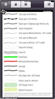
The OFFROAD ATLAS map service depicts Forest Service roads and trails that are designated for motor vehicle use under the official U.S. Government Code of Federal Regulations for identifying designated roads and trails (36 CFR 212.56). Road and Trail MVUM. Additional roads, such as highways, county roads or public roads, are included for mapping purposes. This map service shows the specific types of motorized vehicles allowed on the designated routes and seasonal designation. Data used in this map service are designed to be consistent with the MVUM (Motor Vehicle Use Map). The road and trail data are compiled from the GIS Data Dictionary data and Infra tabular data that the U.S. Forest Service administrative units have prepared for the creation of their MVUMs. This data is published and refreshed on a unit by unit basis as needed and approved by the individual units in order to stay in sync and consistent with the published MVUMs. Interstate, Highway, Other Major Non USFS Roads, and Historic roads for reference are for mapping purposes only and should not be relied upon for their availability for motorized use.
U.S. Geological Survey National Hydrography Dataset, U.S. Department of Transportation Federal Highway Administration HPMS, and various USDA Forest Service datasets used in compiling this information.
- OFFROAD ATLAS App User Reviews
- OFFROAD ATLAS Pros
- OFFROAD ATLAS Cons
- Is OFFROAD ATLAS legit?
- Should I download OFFROAD ATLAS?
- OFFROAD ATLAS Screenshots
- Product details of OFFROAD ATLAS
OFFROAD ATLAS App User Reviews
What do you think about OFFROAD ATLAS app? Ask the appsupports.co community a question about OFFROAD ATLAS!
Please wait! Facebook OFFROAD ATLAS app comments loading...
OFFROAD ATLAS Pros
✓ Off road atlas reviewThis is a useful app in exploring the trails in the parks and forests- much better than the paper maps given by the rangers.Version: 1.5
✓ Excellent app, download BEFORE you go off-roadPeople with low rating clearly didn’t download their maps before going into the wilderness. Duh people , you can’t download after you have no reception, download your maps first . Thanks dev for the great app!.Version: 1.7.1
✓ OFFROAD ATLAS Positive ReviewsOFFROAD ATLAS Cons
✗ PassNot a very good app.Version: 1.6
✗ Absolutely worthlessNo trail no roads. Interstate and blurred pixelated nothing useful. Not even for .99. Don’t get this it is worthless.Version: 1.7.1
✗ OFFROAD ATLAS Negative ReviewsIs OFFROAD ATLAS legit?
⚠ No. OFFROAD ATLAS does not seem legit based on our analysis. This conclusion was arrived at by running over 29 OFFROAD ATLAS user reviews through our NLP machine learning process to determine if users believe the app is legitimate or not. Based on this, AppSupports Legitimacy Score for OFFROAD ATLAS is 35.7/100.
Is OFFROAD ATLAS safe?
⚠ No. OFFROAD ATLAS not seem very safe to us. This is based on our NLP analysis of over 29 user reviews sourced from the IOS appstore and the appstore cumulative rating of 1.8/5. AppSupports Safety Score for OFFROAD ATLAS is 36.2/100.
Should I download OFFROAD ATLAS?
⚠ We are not sure!
OFFROAD ATLAS Screenshots
Product details of OFFROAD ATLAS
- App Name:
- OFFROAD ATLAS
- App Version:
- 1.7.3
- Developer:
- Michael Keiser
- Legitimacy Score:
- 35.7/100
- Safety Score:
- 36.2/100
- Content Rating:
- 4+ Contains no objectionable material!
- Category:
- Navigation, Travel
- Language:
- EN
- App Size:
- 22.48 MB
- Price:
- $0.99
- Bundle Id:
- ms.dynamic.OffroadAtlas
- Relase Date:
- 19 May 2016, Thursday
- Last Update:
- 18 August 2021, Wednesday - 23:16
- Compatibility:
- IOS 9.3 or later
Performance and UX improvements. Various bug fixes. v1.6: More seamless National Forest Motor Vehicle Use Map (MVUM) data coverage showing forest roads and trails for off road/OHV use, satellite imagery, seasonal dates, performance enhancements and ....