
- 19.0LEGITIMACY SCORE
- 19.5SAFETY SCORE
- 4+CONTENT RATING
- $1.99PRICE
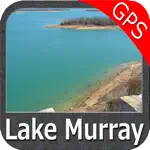
What is Lake Murray SC Nautical Charts? Description of Lake Murray SC Nautical Charts 3142 chars
Flytomap is a valid and interesting alternative, Benetti Yachts
Top Ten since 2008
Featured in : On the Deck
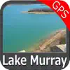
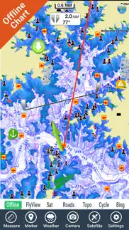
Lake Murray- The whole coverage resident in the app. It works WITHOUT mobile coverage!
• Worldwide Marine,Lakes and Outdoor Maps available, thanks to viewer.flytomap.com
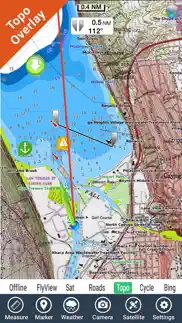
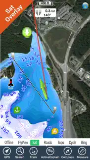
• Worldwide Satellite images overlay on charts
• Worldwide Terrain features overlay on charts, thanks to Open Street Map, Open Cycle Map, Bing,Earth,Topo Chart and GMap
• Local Weather forecast
Now with NOAA,USGS,DRG,Topo raster charts seamless with continuous updates from the official Government server
Now with ActiveCaptain - Worldwide boaters and fishermen community, with * 200.000 + Captains
Use to Explore:
√ Latitudes and Longitudes to go to your favorite places
√ Search your Favorite points directly
√ Zoom, Rotate and Pan fast just by a finger touch
√ Quick Object information just tapping, thanks to vector technology
√ GPS Heading Vector Towards the direction movement
√ Distance Measurement Tool to easily calculate the distance from one location to another
√ Route planning, Waypoints - Insert the target/destination and see in real time your speed, distance and bearing
√ Magnified Lens for all info
√ Unlimited Tracks, Markers, Fishing Spots, Geo-tagged photos, records and share via email, visible on Google, Flytomap Viewer, KMZ format - Store your track without the need of cellular data or mobile signal
√ Select Depth Contours
√ a la carte menu
√ MOB - Man Over Board
√ Quick WP - allows you to instantly record your position and show distance and bearing
√ iOS background mode - Flytomap works in background as well, you can swap with another app and receive/make calls send sms while track recording.
√ Optimized battery usage
√ ActiveCaptain
• View and contribute to the best boaters community available in the world
• Continuous update of all info (including reviews from the deck) about :
• Marinas
• Anchorages
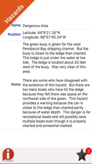
• Hazards
• Local Knowledge
√ Local Marine Weather forecast at a quick tap provide you:
• Day max and min temperature - Current temperature
• Significant wave height, Swell height, Swell period, Swell direction
• Tide data
• Sea temperature
• Wind Speed and direction
• Weather description
• Precipitation & Humidity
• Visibility
• Pressure
• Cloud cover in percentage
• Wind chill/Feels like Temperature
• Water Temperature
• Dew Point Temperature
• Heat Index Temperature
√ And so much more to come - It’s the only app you will ever need! Our charts are installed on: GARMIN NAVICO LOWRANCE B&G NORTHSTAR EAGLE SIMRAD
Follow us:
▶Twitter @flytomap
▶Web Site flytomap.com
▶Web App viewer.flytomap.com
▶Facebook facebook.com/flytomap
Flytomap is committed to constant improvement, this App is developed with the help of professional boaters to get the best experience on the sea, we listen to our users and systematically add the most requested features.
Thank you for the feedback!
"Continued use of GPS running in the background can dramatically decrease battery life."
- Lake Murray SC Nautical Charts App User Reviews
- Lake Murray SC Nautical Charts Pros
- Lake Murray SC Nautical Charts Cons
- Is Lake Murray SC Nautical Charts legit?
- Should I download Lake Murray SC Nautical Charts?
- Lake Murray SC Nautical Charts Screenshots
- Product details of Lake Murray SC Nautical Charts
Lake Murray SC Nautical Charts App User Reviews
What do you think about Lake Murray SC Nautical Charts app? Ask the appsupports.co community a question about Lake Murray SC Nautical Charts!
Please wait! Facebook Lake Murray SC Nautical Charts app comments loading...
Lake Murray SC Nautical Charts Pros
The pros of the Lake Murray SC Nautical Charts application were not found.
✓ Lake Murray SC Nautical Charts Positive ReviewsLake Murray SC Nautical Charts Cons
✗ GPS does not work. Zero stars.Purchased this yesterday to use in the Lake. The GPS never loaded, making the map absolutely useless. Don’t waste your money..Version: 5.4.1
✗ Not sure yetSlow moving seems to lock up often. I’ll have to give it more time..Version: 5.4.1
✗ Lake Murray SC Nautical Charts Negative ReviewsIs Lake Murray SC Nautical Charts legit?
Lake Murray SC Nautical Charts scam ~ legit report is not ready. Please check back later.
Is Lake Murray SC Nautical Charts safe?
Lake Murray SC Nautical Charts safe report is not ready. Please check back later.
Should I download Lake Murray SC Nautical Charts?
Lake Murray SC Nautical Charts download report is not ready. Please check back later.
Lake Murray SC Nautical Charts Screenshots
Product details of Lake Murray SC Nautical Charts
- App Name:
- Lake Murray SC Nautical Charts
- App Version:
- 5.4.1
- Developer:
- Flytomap
- Legitimacy Score:
- 19.0/100
- Safety Score:
- 19.5/100
- Content Rating:
- 4+ Contains no objectionable material!
- Category:
- Navigation, Travel
- Language:
- EN FR IT ES
- App Size:
- 268.49 MB
- Price:
- $1.99
- Bundle Id:
- com.flytomap.LMMurray
- Relase Date:
- 08 October 2016, Saturday
- Last Update:
- 29 September 2017, Friday - 18:59
- Compatibility:
- IOS 9.0 or later
This app has been updated by Apple to display the Apple Watch app icon. Chart download at a finger touch. Enjoy regular updates of your charts free of charge. No subscription required ! Improved navigation info.