

- 99.0LEGITIMACY SCORE
- 99.5SAFETY SCORE
- 4+CONTENT RATING
- FreePRICE
What is Cartograph Maps 3? Description of Cartograph Maps 3 3966 chars
The Cartograph Maps app allows you to view Mapsforge offline vector maps and record tracks. It offers a variety of features such as viewing Mapsforge offline maps, support for OpenAndroMaps render themes, MBTiles maps, hill shading, and multiple map layer stacking. The app also has features for tracks and routing, including track recording, and offline route calculation using BRouter. Other features include measurement tools, cloud sync, search, and built-in offline overlays.
Please contact us if you have any questions, problems, or feature requests: https://www.cartograph.eu/v3/contact/
## Map features
- View Mapsforge offline vector maps (including OpenAndroMaps.org maps!).
- Support for OpenAndroMaps render themes (Elevate, Elements), which are great for hiking, mountainbiking, running, and other outdoor activities.
- Other supported offline map formats: MBTiles (raster and OpenMapTiles MVT vector), TwoWays RMAP, Locus SQLite, Oruxmaps SQLite.
- Supported online map types: Mapbox vector tiles (MVT - OpenMapTiles style), Bing quadkey tile format (raster), OpenStreetMap slippy tile format (raster), raster WMS (web map service, including layers and styles).
- Offline hillshading and slope mapping (*).
- Mapsforge multi-maps (combine multiple Mapsforge maps into a single map) (*).
- Classic Mapsforge and new Mapsforge VTM rendering support.
- Stack multiple map layers on top of each other (including transparency) (*).
- 3D buildings (*).
- Create custom Mapsforge maps (**).
- Grid overlays, including WGS84, UTM, MGRS (military grid reference system), and many local projections (*).
- Supports classical latitude/longitude (WGS84), UTM, MGRS, and many local (proj4) coordinate display projections.
- Online map tile downloader (*) (see https://www.cartograph.eu/v3/online-map-tile-downloader/).
- Image to map calibration tool (*) (https://www.cartograph.eu/v3/image-to-map-calibration-tool/).
- Zoom lock.
## Tracks and routing
- Track recording while the app is in background (*).
- Draw custom tracks using the track drawing tool (*).
- Photo-, video-, and audio waypoints (*).
- BRouter offline route calculation (*).
- OSRM routing.
- Google Directions, Bing Routes (**).
- Basic offline navigation with voice instructions and custom audio instructions (*).
- Waypoint alerts (*).
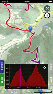
- Current route elevation profile (*).
- Import and export *.gpx, *.kml, *.kmz (only import) tracks.
- Import EXIF JPEG photos and Google Takeout as bookmarks (*).
- Garmin icon support (*).
- Live friend tracking (share your location with friends live on a map) (*).
## Other features
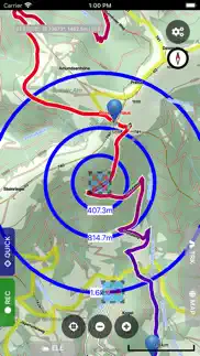
- Measurement tools (distance, elevation profile, circular distance) (*).
- Workspaces (manage sets of maps/overlays/tracks) (*).
- Cloud sync (backup data and synchronize data among multiple devices) using Microsoft OneDrive, DropBox, or your own web server (*).
- "What's here" (reverse geo-code).
- Built-in offline overlays for drinking water, supermarkets, hostels, and restaurants.
- Search: Google Places, Bing, Nominatim (**).
- Supports WunderLINQ and Carpe-Iter-Control.
- Included translations: Czech, English, French, German, Hungarian, Italian, Polish, Traditional Chinese.
- Create your own translations: https://www.cartograph.eu/v3/add-ons/translations/
- Bluetooth heart rate, cadence, and speed sensors.
Items marked with (*) are available in the full version which is available as an in-app-purchase.
Items marked with (**) require credits which can be obtained in the app.
## In app purchases
The Cartograph app offers in-app-purchases for activating all features, and for accessing 3rd party services (such as Google Directions).
A detailed description of all products and the Terms of Use are available here: https://www.cartograph.eu/v3/in-app-purchase-info/
## Disclaimer
The Cartograph app allows you to record your location ("track recording") while the app is in background. Location services can significantly increase battery usage.
- Cartograph Maps 3 App User Reviews
- Cartograph Maps 3 Pros
- Cartograph Maps 3 Cons
- Is Cartograph Maps 3 legit?
- Should I download Cartograph Maps 3?
- Cartograph Maps 3 Screenshots
- Product details of Cartograph Maps 3
Cartograph Maps 3 App User Reviews
What do you think about Cartograph Maps 3 app? Ask the appsupports.co community a question about Cartograph Maps 3!
Please wait! Facebook Cartograph Maps 3 app comments loading...
Cartograph Maps 3 Pros
✓ Excellent mapping appVery useful app, extremely feature rich. Helpful and responsive developer. "Data Not Collected" Thank You!.Version: 3.3.3
✓ Excellent mapping appThis app is an excellent companion to the MacOS version. Extremely feature rich and intuitive to use if you put in a little effort to learn how to use it. The developer is quick to respond if you have problems. The selection of available maps is very good and has many options. I use it mainly for map pins and have hundreds of pins saved. The ability to purchase the app outright is much appreciated as is the Data Not Collected. Well worth the money..Version: 3.3.0
✓ Cartograph Maps 3 Positive ReviewsCartograph Maps 3 Cons
The cons of the Cartograph Maps 3 application were not found.
✗ Cartograph Maps 3 Negative ReviewsIs Cartograph Maps 3 legit?
✅ Yes. Cartograph Maps 3 is 100% legit to us. This conclusion was arrived at by running over 17 Cartograph Maps 3 user reviews through our NLP machine learning process to determine if users believe the app is legitimate or not. Based on this, AppSupports Legitimacy Score for Cartograph Maps 3 is 99.0/100.
Is Cartograph Maps 3 safe?
✅ Yes. Cartograph Maps 3 is quiet safe to use. This is based on our NLP analysis of over 17 user reviews sourced from the IOS appstore and the appstore cumulative rating of 5/5. AppSupports Safety Score for Cartograph Maps 3 is 99.5/100.
Should I download Cartograph Maps 3?
✅ There have been no security reports that makes Cartograph Maps 3 a dangerous app to use on your smartphone right now.
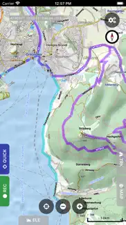
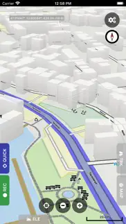
Cartograph Maps 3 Screenshots
Product details of Cartograph Maps 3
- App Name:
- Cartograph Maps 3
- App Version:
- 3.5.8
- Developer:
- Harald Meyer
- Legitimacy Score:
- 99.0/100
- Safety Score:
- 99.5/100
- Content Rating:
- 4+ Contains no objectionable material!
- Category:
- Navigation, Sports
- Language:
- CS EN FR DE HU IT PL ZH
- App Size:
- 82.75 MB
- Price:
- Free
- Bundle Id:
- eu.cartograph3
- Relase Date:
- 08 January 2022, Saturday
- Last Update:
- 20 March 2024, Wednesday - 13:07
- Compatibility:
- IOS 14.0 or later
3.5.8 / 179 (19-03-2024) - Added: Option for opening distance measurement tools from the map popup menu. - Added: Distance measurement tool with elevation profile which uses route calculation (accessible from the map popup menu). - Added: Option for ....