
- 97.0LEGITIMACY SCORE
- 98.5SAFETY SCORE
- 4+CONTENT RATING
- $4.99PRICE
What is Scenic Map Eastern USA? Description of Scenic Map Eastern USA 3697 chars
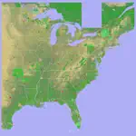
A 3D topo map of the Eastern USA. The vector map data is contained within the app and can be used without an internet connection. Use it in a car, a boat, a plane or while hiking. It is like having more than a third of the country in your pocket.
Scenic Map now covers the entire world via online maps. The maps are cached automatically so they can still be used when there is no cell coverage. Turn on Online Map in the Settings menu and you can then scroll or go to any location on the planet. Satellite image overlays add breathtaking detail and realism to the maps (tap preset 2 or 4 when Online Map is enabled). You can use them as you travel to see what is hidden from view at ground level. This takes moving maps to a whole new level.
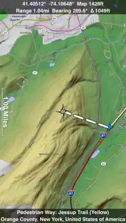
Use the two finger vertical swipe gesture to tilt the map for a 3D view. Scroll like a map or fly like a flight simulator. Enable Joystick Gestures in the Settings menu and then fly around the terrain using a virtual joystick. Prefer only 2D maps? Enable the 2D Map option in the Settings menu.
Scenic Map is simply the best 3D topo map available for a mobile device. You will see incredible detail while scrolling, rotating and zooming perfectly smoothly. You will see every road even if you zoom out to the altitude of a satellite. As you zoom in, you will see every small bump and hollow of the Earth and terrain features as small as ten meters. Unlike old fashioned topo maps, Scenic Map’s roads and trails are up to date thanks to OpenStreetMap.org. It contains polygons for urban areas, shopping malls, an ever growing number of buildings and many other features, The best lake, pond, stream and rivers from the USGS and Canadian public databases are also included.
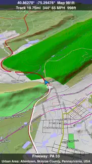
Tap the GPS center button to begin tracking your location. As you move, you will generate a track file. Tracks can be replayed with video like controls to speed up, slow down, pause, restart or skip to the end. You can display existing tracks while recording another if you want to retrace your route. When online, you can automatically create a route from your current GPS location to any other point on the map. Tracks can be received from or sent to other apps in GPX format. GPS recording stops automatically after you have remained stationary for some time or you can choose to manually stop tracking by tapping on the top track in the Tracks view.
Never before have maps been this customizable. For example, you can turn on or off the roads. You can change the lighting direction or remove terrain shading entirely. You can display contour lines even over satellite images. There are five presets which let you quickly switch between map styles. Use Metric, English or Nautical units and choose one of four different coordinate displays including UTM.
Want to learn more about a map feature? Tap the target icon and center the feature under the compass rose to display its name, type, urban area, county, state, elevation and coordinates. You will also see a bearing line back to your current GPS location or from your location to a selected waypoint. The status bar shows the bearing direction and distance along with the map and GPS elevation, the track length, and your current speed and direction of travel.
In-app documentation is provided in the Help section at the top of the Settings menu. Links are provided in the documentation to detailed coverage maps, tutorial videos, installation guide and blog at ScenicMap.com
Map data © OpenStreetMap and contributors under the Open Database License
Scenic Map supports GPS tracking while the app is in the background.
Caution: Continued use of GPS running in the background can dramatically decrease battery life.
- Scenic Map Eastern USA App User Reviews
- Scenic Map Eastern USA Pros
- Scenic Map Eastern USA Cons
- Is Scenic Map Eastern USA legit?
- Should I download Scenic Map Eastern USA?
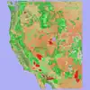
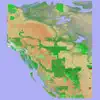
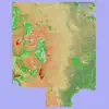
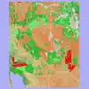
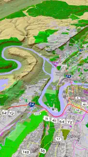
- Scenic Map Eastern USA Screenshots
- Product details of Scenic Map Eastern USA
Scenic Map Eastern USA App User Reviews
What do you think about Scenic Map Eastern USA app? Ask the appsupports.co community a question about Scenic Map Eastern USA!
Please wait! Facebook Scenic Map Eastern USA app comments loading...
Scenic Map Eastern USA Pros
✓ A Home RunAm using with Pad 3G. These excellent maps are downloaded to your iPad and therefore don't depend on an Internet connection. Now you can tell what is below or near by when traveling. They must have been designed by a traveler because they show a lot of real good information most other maps don't like names of bodies of water and historical markers, etc. For the "wish list": would be nice if program could let you draw line / flight path between two cities, even if destination is not on map so you could get an idea of starting point to figure out where you are on map..Version: 0
✓ Gives Topo maps depth!Rather than using your imagination to read topo sas many of us have done for decades, this app allows you to feel like you are in a valley or on a peak. Excellent app..Version: 1.6.1
✓ Scenic Map Eastern USA Positive ReviewsScenic Map Eastern USA Cons
✗ Has potentialIt's neat to be able to visualize an area to hike but when you zoom in to a 100 acre lot or so, it blurs badly. It would be awesome to zoom in better. As we all know, the land may look fairly decent from afar. The current zoom level is good for mountain climbers. I need to better visualize gullies, inclines and such..Version: 1.4.3
✗ Big DisappointmentAfter paying $10 for maps east, it doesn't even compare to Google Maps (which is free) and shows a local neighborhood road incorrectly. Buyer beware!.Version: 1.4.3
✗ Scenic Map Eastern USA Negative ReviewsIs Scenic Map Eastern USA legit?
✅ Yes. Scenic Map Eastern USA is 100% legit to us. This conclusion was arrived at by running over 42 Scenic Map Eastern USA user reviews through our NLP machine learning process to determine if users believe the app is legitimate or not. Based on this, AppSupports Legitimacy Score for Scenic Map Eastern USA is 97.0/100.
Is Scenic Map Eastern USA safe?
✅ Yes. Scenic Map Eastern USA is quiet safe to use. This is based on our NLP analysis of over 42 user reviews sourced from the IOS appstore and the appstore cumulative rating of 5/5. AppSupports Safety Score for Scenic Map Eastern USA is 98.5/100.
Should I download Scenic Map Eastern USA?
✅ There have been no security reports that makes Scenic Map Eastern USA a dangerous app to use on your smartphone right now.
Scenic Map Eastern USA Screenshots

Product details of Scenic Map Eastern USA
- App Name:
- Scenic Map Eastern USA
- App Version:
- 1.9.2
- Developer:
- GrangerFX
- Legitimacy Score:
- 97.0/100
- Safety Score:
- 98.5/100
- Content Rating:
- 4+ Contains no objectionable material!
- Category:
- Navigation, Travel
- Language:
- EN
- App Size:
- 66.12 MB
- Price:
- $4.99
- Bundle Id:
- com.grangerfx.ScenicMapE
- Relase Date:
- 01 April 2010, Thursday
- Last Update:
- 19 January 2024, Friday - 17:34
- Compatibility:
- IOS 16.1 or later
Fast initial download. Maps are then dowloaded automatically. Fixed track recording in iOS 17. Fixed the settings menu in landscape mode on iPhone. Fixed low frame rate when the information bar is enabled. The map's highest detail is now displayed wh....