

- 79.0LEGITIMACY SCORE
- 89.5SAFETY SCORE
- 4+CONTENT RATING
- FreePRICE
What is Bristol Maps? Description of Bristol Maps 2806 chars
Bristol Maps is designed specifically for commercial fishermen to navigate using the latest satellite imagery. Currently serving Bristol Bay and Copper River watersheds. Say goodbye to outdated maps and inaccurate information - our app utilizes the latest, detailed images for increased efficiency, safer fishing trips, and a higher return on investment.
As a fisherman like you, I've always used NOAA charts for the Bay. Given how fast the environment changes, these are at best, unreliable and at worst, dangerous.
For this I developed Bristol Maps, an app that leverages curated satellite images taken during low tide, displaying the current bar locations, and allows for multiple images to be layered. For areas with multiple images at varying tides, this app allows you to see where there will, or won’t be navigable water. Additionally, these images can be overlayed onto the traditional NOAA charts.
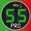
Beyond the core mapping functionality, tide and weather forecasts are also available. Weather can be pinpointed to a location as well as the nearest NOAA zone weather forecast. This information can be combined with the mapping functionality to create digital logs. Location, catch, weather, and tide data can be integrated into a log event. Logs can be overlaid onto the navigation page and analyzed to view catch data by area, gear type (4.75" vs 5"), and weather.
Feature list:
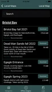
* Satellite overlays available for: Naknek/Kvichak, Egegik, Ugashik, Nushagak, and Copper River. Updated seasonally.
* NOAA overlays available offline for all of Alaska.
* Location grid layouts, organized by color and number, which can replace traditional paper maps or code tables shared by Groups. ie: "I'm over by green 22." A search tool is included to quickly find locations.
* NOAA tide charts available offline for Bristol Bay tide stations. Other locations downloaded as they are used.
* Pinpoint weather forecasts available as well as NOAA zone weather forecasts.
* Boundary lines (with “alarm” functionality), for all major districts are preprogrammed along with the ability to create new boundaries.
* Create Waypoints and Routes. These can also be exported/imported to/from other users to share data.
* Online maps can be streamed with NOAA charts, custom satellite views, a high-res AK Government view, and street view.
* Log entries for recording opener times, district, pictures, sets/deliveries, and automatic tide/weather history.
* Coming this fall, options to have a hard copy 'seasonal' journal.
Bristol Maps has been designed with an intuitive, user friendly interface to solve a common fisherman problem.
Bristol Maps Pricing $150/Year
A two-week free trial is included for testing and includes free cancellation. Subscription includes updates, bug fixes and seasonal imagery additions.
- Bristol Maps App User Reviews
- Bristol Maps Pros
- Bristol Maps Cons
- Is Bristol Maps legit?
- Should I download Bristol Maps?
- Bristol Maps Screenshots
- Product details of Bristol Maps
Bristol Maps App User Reviews
What do you think about Bristol Maps app? Ask the appsupports.co community a question about Bristol Maps!
Please wait! Facebook Bristol Maps app comments loading...
Bristol Maps Pros
The pros of the Bristol Maps application were not found.
✓ Bristol Maps Positive ReviewsBristol Maps Cons
The cons of the Bristol Maps application were not found.
✗ Bristol Maps Negative ReviewsIs Bristol Maps legit?
✅ Yes. Bristol Maps is legit, but not 100% legit to us. This conclusion was arrived at by running over 18 Bristol Maps user reviews through our NLP machine learning process to determine if users believe the app is legitimate or not. Based on this, AppSupports Legitimacy Score for Bristol Maps is 79.0/100.
Is Bristol Maps safe?
✅ Yes. Bristol Maps is quiet safe to use. This is based on our NLP analysis of over 18 user reviews sourced from the IOS appstore and the appstore cumulative rating of 5/5. AppSupports Safety Score for Bristol Maps is 89.5/100.
Should I download Bristol Maps?
✅ There have been no security reports that makes Bristol Maps a dangerous app to use on your smartphone right now.
Bristol Maps Screenshots

Product details of Bristol Maps
- App Name:
- Bristol Maps
- App Version:
- 1.05
- Developer:
- Chris Hager
- Legitimacy Score:
- 79.0/100
- Safety Score:
- 89.5/100
- Content Rating:
- 4+ Contains no objectionable material!
- Category:
- Navigation, Business
- Language:
- App Size:
- 294.05 MB
- Price:
- Free
- Bundle Id:
- com.bygonefisherman.Bristol-Maps
- Relase Date:
- 07 May 2023, Sunday
- Last Update:
- 07 June 2023, Wednesday - 20:47
- Compatibility:
- IOS 10.0 or later
Bug fixes. New beta watch alarm feature..