


- 87.6LEGITIMACY SCORE
- 89.1SAFETY SCORE
- 4+CONTENT RATING
- FreePRICE
What is Air Navigation Pro? Description of Air Navigation Pro 3969 chars
Discover our flight planning & real-time navigation app for free for 28 days!
- Everything you need to fly around the world
- Plan your flight in a few minutes
- Fly relaxed with up-to-date information
Air Navigation Pro is a high-quality flight assistant app for pilots worldwide. Benefit from the following main features:
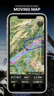
MOVING MAP
Plan and navigate using our interactive moving map. Choose between aeronautical charts, satellite or our vector map as a background. On top of that, the moving map displays waypoints, NOTAM, obstacles and airspaces from our comprehensive, always up-to-date worldwide aeronautical database. Tap on any waypoint directly on the map to easily create a route. Personalize the values shown on the navbar to have exactly the information you need: altitude, vertical speed, bearing, distance to the next waypoint, ETA calculations, etc. Choose the airport departure and arrival procedures for your route to have them also displayed on top of the moving map.
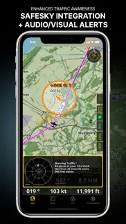
ENHANCED TRAFFIC AWARENESS
Get visual and audio alerts in all languages for nearby conflicting traffic. Choose your preferred traffic icon between generic, aircraft or TCAS symbols. Your safety is important to us, which is why we partnered with SafeSky to ensure our users have live traffic data during their flight. Benefit from the native integration with SafeSky included in our new Smart Lite, Smart Classic and Smart Advanced subscriptions—a two-in-one package!
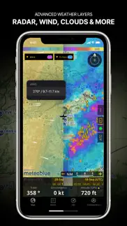
ADVANCED WEATHER LAYERS
In addition to the basic weather reports & forecast of winds, TAF and METAR for your flight, subscribers of the Smart Advanced plan can activate see-through weather layers on top of the moving map. Available layers include rain radar, wind, pressure, clouds and rain, visibility, gust and for Germany, Switzerland, Austria and the Balkans, we also have GAFOR. Tap on any point on the map to see the weather information for that area. Review the weather forecast for up to three days ahead.
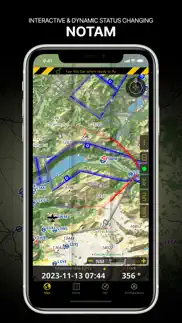
NOTAM
After creating your route, set the departure time in the future to have the moving map display the NOTAM active for that specific time. NOTAM on the map change color dynamically based on their status.
SMARTCHART
Our cutting-edge SmartChart is a highly detailed and intelligent vector-based map that adapts to your needs, providing you with adequate information at any zoom level. The SmartChart optimizes the display of shadows to easily distinguish between valleys and mountains, and the text remains perfectly aligned, guaranteeing optimal readability. Including the latest significant improvements with forests and detailed airport information.
ELEVATION PROFILE & SYNTHETIC VIEW
Enable the profile view below the navbar for enhanced situational awareness of the elevation ahead of you or along your route. Choose the corridor width between 0 to 5 NM and overlay options: airspaces, NOTAM, obstacles, wind components, populated places, etc. Switch to the synthetic view for additional terrain information, plus an artificial horizon with altitude and vertical speed indicators. This function can also be used to pan around while preparing for your flight. Activate TAWS on the moving map as well as on the synthetic view.
AERONAUTICAL CHARTS & APPROACH CHARTS
We offer the most extensive worldwide catalog of aeronautical charts, including the ICAO charts. Have the georeferenced approach charts displayed on top of the moving map or the 3D view.
BRIEFING
Prepare your flight with our briefing section by creating documents with NOTAM and weather charts & stations relevant to your planned route. Optimize time by creating an aircraft profile which will be used in the Briefing section to pre-fill for you the ATC Flight Plan and calculate the W&B.
AND SO MUCH MORE!
Please note that WiFi-only devices do not include an internal GPS receptor; for these devices, an external sensor is required. Refer to our user manual on our website: www.airnavigation.aero for more information.
- Air Navigation Pro App User Reviews
- Air Navigation Pro Pros
- Air Navigation Pro Cons
- Is Air Navigation Pro legit?
- Should I download Air Navigation Pro?
- Air Navigation Pro Screenshots
- Product details of Air Navigation Pro
Air Navigation Pro App User Reviews
What do you think about Air Navigation Pro app? Ask the appsupports.co community a question about Air Navigation Pro!
Please wait! Facebook Air Navigation Pro app comments loading...
Air Navigation Pro Pros
✓ Simple et facile d’utilisation.Nous sommes plusieurs ici dans CHARLEVOIX, Québec,Canada à utiliser cette application qui fonctionne très bien et répond à nos besoins..Version: 7.2
✓ FantasticI'm using this on a WiFi only 64Gb iPad 1 with a separate Dual XGPS150. There seem to be a mix of reviews, but as far as I am concerned it is fantastic. I flew IFR from Leicester to Le Touquet via Shoreham and back again to give it a try. I'd set up the routes using my own custom waypoints all of which is really easy and quick (once I'd read the manual). In flight it tracks smoothly and perfectly. It is more accurate than both the VOR and RNAV I had in the plane, it is more accurate than the DI particularly when climbing. As I read more about what I can do with it, I am sure I will be even more impressed. I need to figure out whether I can track the plane on approach plates. Value for money and functionality wise, especially given you will get free updates, a must have.Version: 4.03
✓ Air Navigation Pro Positive ReviewsAir Navigation Pro Cons
✗ Errors in Air Space!I have used this App for flying VFR in the UK for over 4 years. At first it was a great basic App that was perfect for easy use as a check of where you were and Flt Planning. It then got over complicated & simple tasks like updates /printing or naming your Flt plans were hidden within sub menus. Recently, during a Flt I was alerted to a large TMZ around EGNT. Newcastle. After checking with fellow pilots on Skydemon & CAA it was obvious there was an issue and the question was are there any other errors? I emailed the support team and after 3 weeks they said it would be sorted in the next update. A month later it was sorted out but the main reason we use these types of Apps is for accurate Airspace updates to keep us safe and out of trouble not for bells and whistles we will never use. When my subscription ends I’ll now join the crowd of Skydemon users unless they release a back to basics VFR APP..Version: 8.0.91
✗ USA sectionals display fuzzyGREAT APP! .1 version has some needed chgs. Revision to fuzzy maps... Deleted everything. Re-downladed app and maps and maps are clear again. The USA sectionals when zooming down to a 6 mile setting display properly but you see very little around your plane. Zooming out one level more produces a fuzzy Vfr sectional that is unreadable. If this is fixed then it's a great update otherwise it's unusable..Version: 4.0.1
✗ Air Navigation Pro Negative ReviewsIs Air Navigation Pro legit?
✅ Yes. Air Navigation Pro is 100% legit to us. This conclusion was arrived at by running over 585 Air Navigation Pro user reviews through our NLP machine learning process to determine if users believe the app is legitimate or not. Based on this, AppSupports Legitimacy Score for Air Navigation Pro is 87.6/100.
Is Air Navigation Pro safe?
✅ Yes. Air Navigation Pro is quiet safe to use. This is based on our NLP analysis of over 585 user reviews sourced from the IOS appstore and the appstore cumulative rating of 4.5/5. AppSupports Safety Score for Air Navigation Pro is 89.1/100.
Should I download Air Navigation Pro?
✅ There have been no security reports that makes Air Navigation Pro a dangerous app to use on your smartphone right now.
Air Navigation Pro Screenshots
Product details of Air Navigation Pro
- App Name:
- Air Navigation Pro
- App Version:
- 8.3.370
- Developer:
- Xample Sarl
- Legitimacy Score:
- 87.6/100
- Safety Score:
- 89.1/100
- Content Rating:
- 4+ Contains no objectionable material!
- Category:
- Navigation, Travel
- Language:
- EN FR DE IT JA NB PT RU ES TR
- App Size:
- 194.49 MB
- Price:
- Free
- Bundle Id:
- ch.xample.Airnav
- Relase Date:
- 06 January 2009, Tuesday
- Last Update:
- 18 April 2024, Thursday - 07:13
- Compatibility:
- IOS 13.0 or later
- Introducing Synthetic View: Our 3D View has received an upgrade with an improved UI and an integrated Moving Map preview! - New Map Visibility Settings: Take control of overlapping maps by setting custom zoom level ranges, ensuring smooth transitio....