

- 41.4LEGITIMACY SCORE
- 42.9SAFETY SCORE
- 4+CONTENT RATING
- $9.99PRICE
What is Florida Nautical Charts GPS HD? Description of Florida Nautical Charts GPS HD 2927 chars
Flytomap is a valid and interesting alternative, Benetti Yachts
Featured in : On the Deck
Florida, Bahamas and North Cuba coverage resident in the app. It works WITHOUT mobile coverage!
• Worldwide Marine and Outdoor Maps available, thanks to viewer.flytomap.com
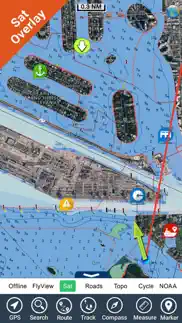
• Worldwide Satellite images overlay on charts
• Worldwide Terrain features overlay on charts, thanks to Open Street Map, Open Cycle Map, Bing, Earth,Topo Chart and GMap
• Local Marine Weather forecast
• Available on iWatch
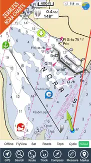
Now with NOAA raster charts seamless with continuous updates from the official Government server
Get this chart for your Lowrance, Simrad and B&G at a very competitive price
Use to Explore:
√ Latitudes and Longitudes to go to your favorite places
√ Search your Favorite points directly
√ Zoom, Rotate and Pan fast just by a finger touch
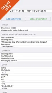
√ Quick Object information just tapping, thanks to vector technology
√ GPS Heading Vector Towards the direction movement
√ Distance Measurement Tool to easily calculate the distance from one location to another
√ Route planning, unlimited Waypoints - Insert the target/destination and see in real time your speed, distance and bearing
√ Magnified Lens for all info
√ Unlimited Tracks, Markers, Geo-tagged photos, records and share via email, visible on Google, Flytomap Viewer, KMZ format - Store your track without the need of cellular data or mobile signal
√ Select Depth Contours
√ a la carte menu
√ MOB - Man Over Board
√ Quick WP - allows you to instantly record your position and show distance and bearing
√ iOS background mode - Flytomap works in background as well, you can swap with another app and receive/make calls send sms while track recording.
√ Optimized battery usage
• Continuous update of all info (including reviews from the deck) about :
• Marinas
• Anchorages
• Hazards
• Local Knowledge
√ Local Marine Weather forecast at a quick tap provide you:
• Day max and min temperature - Current temperature
• Significant wave height, Swell height, Swell period, Swell direction
• Tide data
• Sea temperature
• Wind Speed and direction
• Weather description
• Precipitation & Humidity
• Visibility
• Pressure
• Cloud cover in percentage
• Wind chill/Feels like Temperature
• Water Temperature
• Dew Point Temperature
• Heat Index Temperature
√ And so much more to come - It’s the only app you will ever need! Our charts are installed on: NAVICO LOWRANCE B&G NORTHSTAR EAGLE SIMRAD
Follow us:
▶Twitter @flytomap
▶Web Site flytomap.com
▶Web App viewer.flytomap.com
▶Facebook facebook.com/flytomap
Flytomap is committed to constant improvement, this App is developed with the help of professional boaters to get the best experience on the sea, we listen to our users and systematically add the most requested features.
Thank you for the feedback!
- Florida Nautical Charts GPS HD App User Reviews
- Florida Nautical Charts GPS HD Pros
- Florida Nautical Charts GPS HD Cons
- Is Florida Nautical Charts GPS HD legit?
- Should I download Florida Nautical Charts GPS HD?
- Florida Nautical Charts GPS HD Screenshots
- Product details of Florida Nautical Charts GPS HD
Florida Nautical Charts GPS HD App User Reviews
What do you think about Florida Nautical Charts GPS HD app? Ask the appsupports.co community a question about Florida Nautical Charts GPS HD!
Please wait! Facebook Florida Nautical Charts GPS HD app comments loading...
Florida Nautical Charts GPS HD Pros
✓ So much in the appWill never have to look back. No need to buy a big expensive GPS because this app has everything they would have plus a ton more..Version: 0
✓ Great coverageI am cruising from the keys to cuba and bahamas, all these areas are included and well detailed. * thanks for this update on routes with multiple wp, banner adv OFF is higly appreciated. magnifier should be default on iphone 11 Thanks!.Version: 5.9.1
✓ Florida Nautical Charts GPS HD Positive ReviewsFlorida Nautical Charts GPS HD Cons
✗ Not working! Needs a lot of workGreat concept if everything worked properly. GPS doesn’t work half the time. Overlays get stacked on top of each other. Freezes up constantly and could be a lot more helpful if a few things were added and those things fixed. Not worth the money if it cannot be used..Version: 5.7.2
✗ Florida Gulf CoastI purchased this APP approx. 4 months ago. After repeated tries by myself and others, we have never been able to get "tracks". No customer support, a waste of $9.99.Version: 4.1
✗ Florida Nautical Charts GPS HD Negative ReviewsIs Florida Nautical Charts GPS HD legit?
⚠ No. Florida Nautical Charts GPS HD does not seem legit based on our analysis. This conclusion was arrived at by running over 47 Florida Nautical Charts GPS HD user reviews through our NLP machine learning process to determine if users believe the app is legitimate or not. Based on this, AppSupports Legitimacy Score for Florida Nautical Charts GPS HD is 41.4/100.
Is Florida Nautical Charts GPS HD safe?
⚠ No. Florida Nautical Charts GPS HD not seem very safe to us. This is based on our NLP analysis of over 47 user reviews sourced from the IOS appstore and the appstore cumulative rating of 2.2/5. AppSupports Safety Score for Florida Nautical Charts GPS HD is 42.9/100.
Should I download Florida Nautical Charts GPS HD?
⚠ We are not sure!
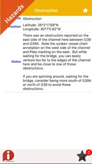
Florida Nautical Charts GPS HD Screenshots
Product details of Florida Nautical Charts GPS HD
- App Name:
- Florida Nautical Charts GPS HD
- App Version:
- 5.9.2
- Developer:
- Flytomap
- Legitimacy Score:
- 41.4/100
- Safety Score:
- 42.9/100
- Content Rating:
- 4+ Contains no objectionable material!
- Category:
- Navigation, Travel
- Language:
- EN FR DE IT ES
- App Size:
- 129.30 MB
- Price:
- $9.99
- Bundle Id:
- com.flytomap.WMFloridaHD
- Relase Date:
- 17 August 2010, Tuesday
- Last Update:
- 19 March 2022, Saturday - 15:17
- Compatibility:
- IOS 9.0 or later
Chart updated, rebuilt for latest iOS..