

- 74.0LEGITIMACY SCORE
- 77.0SAFETY SCORE
- 4+CONTENT RATING
- FreePRICE
What is Topography Lite? Description of Topography Lite 3791 chars
The application is very useful to Civil Engineers, Architects, Surveyors, and those interested in measuring a surface area or converting its coordinates to UTM EGSA87.
This tool enables users to:
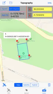
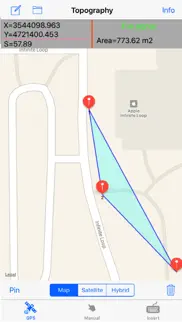
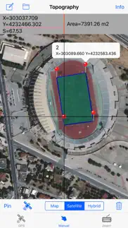
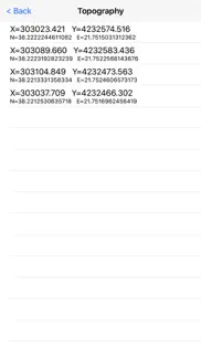
1. Convert the coordinates (x,y) to UTM EGSA87 Datum
2. Calculate the area of a polygon in square meters (m2)
3. Send the above measurements by e-mail in [dxf] file format. The dxf file can be opened in a MAC or a PC by any drawing application like Autocad.
4. Send measurements by e-mail in [kml] file format. The kml file can be opened in a MAC or a PC or iPhone by GoogleEarth application.
5. Send measurements by e-mail in [TXT] file format. The text file contains coordinates either in EGSA87 Datum or Latitude and Longitude in decimal degrees.
The measurements mentioned above can be provided not only by placing the iPhone in each border of a surface area, but also from distance (when users are on their bed or their sofa). Users may also have their final measurements by entering the coordinates either in EGSA87 Datum or Latitude and Longitude in decimal degrees.
*********Caution:
The Free Version of the program has the additional alteration of EGSA87 coordination by 20% and reduce the measured points.
For accurate results buy the full version !
----------------------------------------------------------------------------------
Η εφαρμογή είναι πολύ χρήσιμη για Πολιτικούς Μηχανικούς , Αρχιτέκτονες , τοπογράφους , και σε όσους ενδιαφέρονται για τη μέτρηση μιας επιφάνειας (γεωτεμαχίου, οικοπέδου κτλ) ή για την μετατροπή των συντεταγμένων της σε UTM ΕΓΣΑ87.
Αυτή η εφαρμογή επιτρέπει στους χρήστες να :
1. Να μετατρέψουν τις συντεταγμένες ( x , y ) στο UTM ΕΓΣΑ87 Datum
2. Να υπολογίσουν το εμβαδόν ενός πολυγώνου σε τετραγωνικά μέτρα (m2)
3. Να στείλουν τις παραπάνω μετρήσεις μέσω e-mail σε μορφή αρχείου [dxf]. Το αρχείο DXF μπορεί να ανοίξει σε MAC ή PC από οποιαδήποτε cad εφαρμογή όπως το Autocad.
4. Να στείλουν τις παραπάνω μετρήσεις μέσω σε e-mail σε μορφή αρχείου [ΚΜL]. Το αρχείο KML μπορεί να ανοίξει σε MAC ή PC ή στο iPhone από την εφαρμογή GoogleEarth.
Οι μετρήσεις που αναφέρονται παραπάνω μπορεί να προέρχονται όχι μόνο από τη τοποθέτηση του iPhone σε κάθε κορυφή της επιφάνειας που θέλουμε να μετρήσουμε, αλλά και από απόσταση, βρίσκοντας την επιφάνεια που μας ενδιαφέρει από τον χάρτη της εφαρμογής μας και επιλέγοντας τις κορυφές της. Οι χρήστες μπορούν επίσης να έχουν τελικές μετρήσεις τους, εισάγοντας τις συντεταγμένες είτε σε ΕΓΣΑ87 Datum ή το γεωγραφικό πλάτος και το γεωγραφικό μήκος σε δεκαδικούς βαθμούς
*********Προσοχή:
Η Free Version του προγράμματος έχει επιπρόσθετη αλλoίωση των συντεραγμένων ΕΓΣΑ87 κατα 20% καθώς και περιορισμό μετρούμενων σημείων.
Για ακριβή αποτελέσματα αγοράστε την πλήρη έκδοση !
- Topography Lite App User Reviews
- Topography Lite Pros
- Topography Lite Cons
- Is Topography Lite legit?
- Should I download Topography Lite?
- Topography Lite Screenshots
- Product details of Topography Lite
Topography Lite App User Reviews
What do you think about Topography Lite app? Ask the appsupports.co community a question about Topography Lite!
Please wait! Facebook Topography Lite app comments loading...
Topography Lite Pros
The pros of the Topography Lite application were not found.
✓ Topography Lite Positive ReviewsTopography Lite Cons
✗ Doesn't do anythingAds block important parts of the screen and can't find the button to drop the pin, which is necessary..Version: 2.2
✗ Garbage!This app is hidden behind advertisements. The only thing it would be good for is measuring the area of property with known boundaries...it is not a GPS (and doesn't claim to be)..Version: 2.2
✗ Topography Lite Negative ReviewsIs Topography Lite legit?
✅ Yes. Topography Lite is legit, but not 100% legit to us. This conclusion was arrived at by running over 69 Topography Lite user reviews through our NLP machine learning process to determine if users believe the app is legitimate or not. Based on this, AppSupports Legitimacy Score for Topography Lite is 74.0/100.
Is Topography Lite safe?
✅ Yes. Topography Lite is quiet safe to use. This is based on our NLP analysis of over 69 user reviews sourced from the IOS appstore and the appstore cumulative rating of 4/5. AppSupports Safety Score for Topography Lite is 77.0/100.
Should I download Topography Lite?
✅ There have been no security reports that makes Topography Lite a dangerous app to use on your smartphone right now.
Topography Lite Screenshots
Product details of Topography Lite
- App Name:
- Topography Lite
- App Version:
- 4.5
- Developer:
- Georgios Graikousis
- Legitimacy Score:
- 74.0/100
- Safety Score:
- 77.0/100
- Content Rating:
- 4+ Contains no objectionable material!
- Category:
- Navigation, Utilities
- Language:
- EN
- App Size:
- 26.80 MB
- Price:
- Free
- Bundle Id:
- com.grcad.Egsa87.Topography-Freefree
- Relase Date:
- 24 August 2013, Saturday
- Last Update:
- 26 September 2018, Wednesday - 14:04
- Compatibility:
- IOS 9.0 or later
Perimeter calculation added.