

- 81.3LEGITIMACY SCORE
- 84.8SAFETY SCORE
- 4+CONTENT RATING
- $3.99PRICE
What is US Public Lands? Description of US Public Lands 3669 chars
The US Federal Governments owns nearly 650 million acres of land - almost 30 percent of the land area of the United States.
These are lands that are held for all Americans.
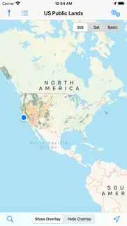
US Public Lands allows you to quickly retrieve the boundaries of these properties without carrying physical maps, books, or digging deep online.
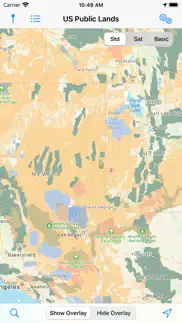
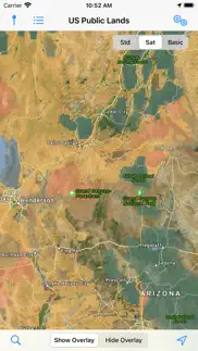
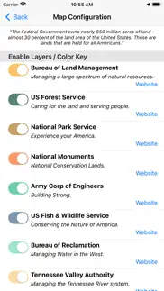
Included in the app are on-device (fully works offline), individually selectable & beautifully colored map layers for most of the properties administered by the federal government:
- Bureau of Land Management (BLM)
- US Forest Service (FS)
- National Park Service (NPS)
- Army Corp of Engineers (ACOE)
- US Fish & Wildlife Service
- Bureau of Reclamation
- Tennessee Valley Authority
- Department of Defense (military bases & installations)
- Other (National Laboratories, Test Sites, etc...)
Key Benefits & Features
- Know which US agency owns and operates the land you're on or are heading to. Use the "Layers" icon to select which agencies you want displayed to create your own custom map. (Hint, the toggles are color coded to the color each layer is displayed in.)
- Links are provided to each agency's website within the app, so that you can further your research as to what land use rules apply for each public land type - such as permits, fees, activities allowed, and limits of stay.
- Map layers are stored on device - no internet connection required.
- Be sure to turn on the 'Basic' base map to see the US Public Land labels for each land area. This base map layer is also stored entirely on your device, and can be utilized if you do not have an internet connection or would like to conserve bandwidth.
- If you have an internet connection (or have cached them before going out of signal), you can utilize the built in Apple Maps and satellite view maps as the base layer underneath the public land overlays.
- A boondocker's assistant - While US Public Lands is not specifically a camp site locator and does not have a database of specific sites, by turning on the satellite view map, you can better scout out trails, roads and signs of dispersed camping locations within the boundaries of the public land resources.
- Quickly toggle between 'Show' and 'Hide' via the "Map" icon to more clearly see satellite images below.
- If you have GPS access on your device, click the 'Locate Me' icon to show your present location - know what type of land you're on right now!
- Built in search tool locates anything on device maps supports (requires internet access) - including cities, states, zip codes, addresses and points of interest. A pin is dropped at the search location.
Thank you to the Protected Area Database (PAD-US) of the U.S. Geological Survey for providing the public domain raw map data that we’ve been able to utilize to create this interactive overlayable mapping & navigation tool. We will update our maps in the future to stay in sync with improvements to this data set.
Please note, the USGS PAD-US database contains the “most up-to-date aggregation of Federal lands and waters” available, but this database is still evolving and some locations may not be listed and others may not have precisely accurate boundaries. Resolution across the nation may vary. And always remember - there may be private unmapped inholdings within any public lands - so always pay attention to local signage, indications, and information.
The US Public Lands app should only be used as an overview, and you should always confirm more precise details by consulting local field offices, administration websites, and other resources. Do not solely rely on this app for determining if you are on public or private land.
- US Public Lands App User Reviews
- US Public Lands Pros
- US Public Lands Cons
- Is US Public Lands legit?
- Should I download US Public Lands?
- US Public Lands Screenshots
- Product details of US Public Lands
US Public Lands App User Reviews
What do you think about US Public Lands app? Ask the appsupports.co community a question about US Public Lands!
Please wait! Facebook US Public Lands app comments loading...
US Public Lands Pros
✓ Appreciated simplicityI use more detailed apps like Gaia GPS with premium layers to do deep investigation. But this app is great to have un the toolbox for its shear simplicity. Great for quick regional overviews to gather a sense of where to more granularly investigate. Thanks for making great use of these datasets, and implementing them in a clean and elegant way. Looks great on ipad..Version: 2019.7
✓ Amazing appI love this app and I have been using it for years. Great for cross referencing sat maps to find free places to camp..Version: 2019.7
✓ US Public Lands Positive ReviewsUS Public Lands Cons
✗ DisappointingI purchased this app hoping to make sure I don’t intrude on private property near the winnemucca area . Not sure how I’m supposed to do that with areas of maps that look like a checkered board. Even if I zoom in, the checkers don’t become defined areas. Wish I could post a picture of what it looks like. Terrible. Waste of money.Version: 2019.7
✗ Totalement inutileNe gaspillez pas votre argent. Faites plutôt une brève recherche sur le web.Version: 2015.2
✗ US Public Lands Negative ReviewsIs US Public Lands legit?
✅ Yes. US Public Lands is 100% legit to us. This conclusion was arrived at by running over 711 US Public Lands user reviews through our NLP machine learning process to determine if users believe the app is legitimate or not. Based on this, AppSupports Legitimacy Score for US Public Lands is 81.3/100.
Is US Public Lands safe?
✅ Yes. US Public Lands is quiet safe to use. This is based on our NLP analysis of over 711 user reviews sourced from the IOS appstore and the appstore cumulative rating of 4.4/5. AppSupports Safety Score for US Public Lands is 84.8/100.
Should I download US Public Lands?
✅ There have been no security reports that makes US Public Lands a dangerous app to use on your smartphone right now.
US Public Lands Screenshots
Product details of US Public Lands
- App Name:
- US Public Lands
- App Version:
- 2022.11
- Developer:
- Two Steps Beyond
- Legitimacy Score:
- 81.3/100
- Safety Score:
- 84.8/100
- Content Rating:
- 4+ Contains no objectionable material!
- Language:
- EN
- App Size:
- 189.51 MB
- Price:
- $3.99
- Bundle Id:
- com.twostepsbeyond.public-lands
- Relase Date:
- 11 April 2014, Friday
- Last Update:
- 29 November 2022, Tuesday - 14:58
- Compatibility:
- IOS 12.0 or later
Updated the maps to reflect the latest PAD US map release.Removed some older notification dialogs..