


- 84.8LEGITIMACY SCORE
- 89.3SAFETY SCORE
- 4+CONTENT RATING
- FreePRICE
What is OS Maps: Walking & Bike Trails? Description of OS Maps: Walking & Bike Trails 3839 chars
Create your adventures your way & let OS Maps guide you on stunning routes across the UK & beyond. Get more from the outdoors, with more freedom to explore, more confidence to tackle that next challenge & more adventures along the way. OS Maps is the official app by Ordnance Survey & your guide in the great outdoors.
Why you’ll love using OS Maps:
EXPLORE & PLAN HIKES, RUNS OR RIDES
Whether you are planning a walk, hike, run or ride; OS Maps lets you create outdoor adventures with trusted mapping & navigation tools from the experts at Ordnance Survey, Britain’s national mapping service.
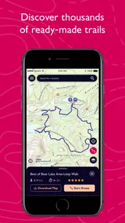
DISCOVER THOUSANDS OF READY-MADE ROUTES
Get outside with curated routes from outdoor experts & organisations such as Trail, Country Walking, Mountain Bike UK, BBC Countryfile & more.
ICONIC OS MAPPING
Subscribe to unlock the detail & accuracy of OS leisure maps including OS Explorer 1:25,000 & OS Landranger 1:50,000 & now with global mapping & topographic mapping for USA, Australia & New Zealand to keep you exploring all over the world.
CREATE YOUR OWN ADVENTURES
Best in class route planning & navigation tools mean you can get off the beaten track & explore with more freedom. Plan routes with quick & easy snap-to-path route plotting, then save & share with your friends to plan that next epic day in the outdoors.
NO SIGNAL? NO PROBLEM
Download maps & routes to your phone to view offline, so they’re ready, whenever & wherever you need them. View any part of GB even without signal & export to your GPS device.
UNLIMITED PRINTING
Print copies of all your routes & maps to take with you, so you always have a backup to hand.
USE ON EVERY DEVICE
Sync your activities between across devices, on desktop, mobile & Apple Watch. On desktop, premium users can use our 3D Aerial Layer & route fly-throughs to see the landscape, terrain & explore in stunning 3D.
TRACK & RECORD ACTIVITIES
Use the activity recording feature to keep a log of your activity history. Follow along, save your activity, review it & turn it into a new route to share & follow again later.
RECOMMENDED BY THE EXPERTS
Ordnance Survey is proud to partner with Mountain Rescue England & Wales, with OS Maps as their recommended app to help you keep on track, & keep safe when heading outside.
TABLETOP 3D
Preview a route before you tackle it, ensure it’s suitable for your level of fitness & avoid any surprises. Our 3D model feature lets you check out your routes from the comfort of your home.
SUBSCRIPTION INFORMATION
OS Maps premium is available through a 1 month or 1 year subscription. Prices are posted in GBP but may vary by country or when converted to local currency. Subscriptions will auto-renew. Payment will be charged to iTunes Account at confirmation of purchase. The subscription automatically renews unless auto-renew is turned off at least 24-hours before the end of the current period. Your account will be charged for renewal within 24-hours prior to the end of the current period, & identify the cost of the renewal. Subscriptions may be managed by the user & auto-renewal may be turned off by going to the user's Account Settings after purchase.
Terms & Conditions at os.uk/termsosmaps
USEFUL INFORMATION
Battery life while using the app can be extended downloading maps offline prior to use, operating in Flight Mode (the GPS will still work) & turning off the screen when not in use. We release updates to all of our apps on an ongoing basis to improve stability & add extra features. Topographic mapping is available for UK (including Northern Ireland), USA, Australia & New Zealand. Your feedback & comments about this app are important to us. Leave a review or use os.uk/contact to get in touch.
*This feature uses Apple's ARKit which requires an iPhone 6s, iPhone SE, iPad 2017, iPad Pro or any later device.
- OS Maps: Walking & Bike Trails App User Reviews
- OS Maps: Walking & Bike Trails Pros
- OS Maps: Walking & Bike Trails Cons
- Is OS Maps: Walking & Bike Trails legit?
- Should I download OS Maps: Walking & Bike Trails?
- OS Maps: Walking & Bike Trails Screenshots
- Product details of OS Maps: Walking & Bike Trails
OS Maps: Walking & Bike Trails App User Reviews
What do you think about OS Maps: Walking & Bike Trails app? Ask the appsupports.co community a question about OS Maps: Walking & Bike Trails!
Please wait! Facebook OS Maps: Walking & Bike Trails app comments loading...
OS Maps: Walking & Bike Trails Pros
✓ Very good. Missing one basic thing!I use this app whenever visiting family in the UK, for hikes and runs as it points out locations of historical interest as well as footpaths in the countryside. I’m back for the first time in 4 years (thanks covid) and just in time to try the new snap to path feature which is great! Wow! The one thing missing is that I can’t save locations the map and to a list. I’d love to be able to save “mum’s house”, as well as other destinations I’d like to visit without having to plot a route. Love OS, they’re great maps!.Version: 4.6.0
✓ Doesn’t work. Period.All you get on trying to log in to the iPhone/iPad app is “Unknown error occurred. Please try again.” Really helpful. I paid for the Premium version so that I could import routes. Just getting the login working on their site was a chore; their domain and session handling seems a mess. And now I find the iPhone app is effectively useless. Can I have my money back please?.Version: 3.6.2
✓ OS Maps: Walking & Bike Trails Positive ReviewsOS Maps: Walking & Bike Trails Cons
✗ Not serious about safetyThe app developers are pretty casual with their users’ safety. Offline maps are an important safety tool on a hike and if you can’t rely on them being available (or if they’re not available at all zoom levels), it can be a risk to use them on a hike. Given that this is basically a government funded endeavour, it’s terrible how careless they are..Version: 2.0.6
✗ Frustrating.Have had the app for over a year and have a premium subscription. Use the app on an iPhone X and generally find it very useful for mapping, great for creating a route, but as frustrating as hell for Recording a route. I have all iPhone settings as they should be - allow location use in background etc, but no matter what I try the app WILL NOT continue to track my movements once the phone is locked and back in my pocket. It just stops recording the route until the next time I have the app open in front of me, then plots a STRAIGHT LINE between my last recorded location and my current location. Unless I literally hold the phone in front of me with the app open and on-screen this happens every time. When all I want to do is start recording then pop it in my pocket doing its thing until I finish my walk this makes the feature completely useless. Oh, and it didn’t do this before the major update released at the end of last year - it worked fine..Version: 2.0.22
✗ OS Maps: Walking & Bike Trails Negative ReviewsIs OS Maps: Walking & Bike Trails legit?
✅ Yes. OS Maps: Walking & Bike Trails is 100% legit to us. This conclusion was arrived at by running over 326 OS Maps: Walking & Bike Trails user reviews through our NLP machine learning process to determine if users believe the app is legitimate or not. Based on this, AppSupports Legitimacy Score for OS Maps: Walking & Bike Trails is 84.8/100.
Is OS Maps: Walking & Bike Trails safe?
✅ Yes. OS Maps: Walking & Bike Trails is quiet safe to use. This is based on our NLP analysis of over 326 user reviews sourced from the IOS appstore and the appstore cumulative rating of 4.6/5. AppSupports Safety Score for OS Maps: Walking & Bike Trails is 89.3/100.
Should I download OS Maps: Walking & Bike Trails?
✅ There have been no security reports that makes OS Maps: Walking & Bike Trails a dangerous app to use on your smartphone right now.
OS Maps: Walking & Bike Trails Screenshots


Product details of OS Maps: Walking & Bike Trails
- App Name:
- OS Maps: Walking & Bike Trails
- App Version:
- 5.0.6
- Developer:
- Ordnance Survey
- Legitimacy Score:
- 84.8/100
- Safety Score:
- 89.3/100
- Content Rating:
- 4+ Contains no objectionable material!
- Category:
- Navigation, Health & Fitness
- Language:
- EN
- App Size:
- 106.13 MB
- Price:
- Free
- Bundle Id:
- uk.os.osmaps
- Relase Date:
- 10 June 2015, Wednesday
- Last Update:
- 17 April 2024, Wednesday - 12:23
- Compatibility:
- IOS 15.0 or later
This latest release addresses minor bugs such as improvements to exporting a route on iPad..