

- 88.4LEGITIMACY SCORE
- 88.9SAFETY SCORE
- 4+CONTENT RATING
- FreePRICE
What is Fishing Points - Lake Maps? Description of Fishing Points - Lake Maps 3858 chars
Only app with Fishing AI to find productive fishing breaklines and fishing spots. It offers access to Fishing Lake Depth Maps & Marine Charts with fishing points for USA, Canada, UK, etc. Coverage includes NOAA marine vector charts,freshwater lake maps,USACE inland river maps (HD/1ft bathymetry/Sonar Contours).
First Fishing GPS app to have route assistance with Voice Prompts for marine navigation. You can create new boating routes or import existing GPX/KML routes. It supports Nautical Charts course up orientation. Includes Tide & Currents prediction.
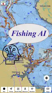
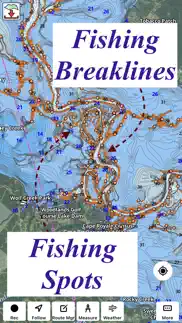
► FISHING AI
Emulates an expert angler. It is trained to include multiple variables.
√ Lake bathymetry/topography
* Point Bars
* Humps / Underwater Islands
* Channels
* Saddles
* Artificial / Man Made Structures
* River Bed
* Ledges
* Side Feeder Streams
* Pits
* And more...
√ Local Knowledge for a lake gained over the years about likely hot spots
√ Weather Patterns
√ Vegetation Maps
√ Fish Type
►FEATURES
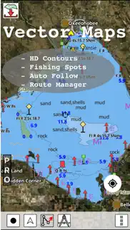
√ Beautiful & detailed Hardware/GPU accelerated vector charts (text stays upright on rotation)
√ Long press to query the details of Marine object (Buoy,Lights,Obstruction etc).
√ Customizable depth(Ft/Fathom/Meter) & distance units(km/mi/NM)
√ Customizable Shallow Depth.
√ Record tracks,Autofollow with real-time track overlay & predicted path vector.
√ Voice Prompts for marine navigation (requires GPS )
√ 1ft / 3ft depth contour maps for anglers for selected lake maps.
√ Supports GPX/KML for boating route editing/import.
√ Tide & Currents prediction.
√ Seamless chart quilting of marine charts
√ Enter or import Waypoints.
► MAPS
It includes unlimited updates for 1 year.
√ Lake Maps & Nautical Charts with Fishing Points covering US, UK,Germany, NL, AU etc.
►ROUTE MANAGEMENT / TRIP PLANNING
√ Create New Route/Edit Existing Routes
√ Move Points
√ Add points to an existing route leg
√ Delete / Rename points
√ Import GPX,KML & KMZ files
√ Plot/Edit Routes
√ Enter Waypoints
√ Share/Export Routes,Tracks&Markers
√ Reverse Routes
►GPS FEATURES
√ Auto Follow
* Real Time Track Overlay
* Predicted Path Vector
* Course Up(Text stays upright)
* Speed & Heading
√ Route Assistance With Voice Prompts
* Prompts when approaching a boating route marker
* Continous distance & ETA updates
* Alerts when sailing/boating off route
* Alerts when boating in wrong direction
√ Record Tracks
►TIDE & CURRENTS
* For US, Canada, UK, Germany & New Zealand
* High/Low Tides
* Tidal Current Prediction
* Active Current Stations
► SHARING
* Share tracks/routes/markers on Facebook & Twitter
* Export tracks/routes/markers as compressed GPX files.
Sample Charts
√ KISSIMMEE, Lake Apopka, ISTOKPOGA, SEMINOLE, TOHOPEKALIGA, Lake Tohopekaliga, HARRIS, Lakeocklawaha,
√ East Lake Tohopekaliga, Bighenderson, GRIFFIN, MONROE, TALQUIN, Lake Eustis, EUSTIS, WEOHYAKAPKA,
√ ORANGE , HARNEY, MICCOSUKEE, HATCHINEHA, SANTA FE SWAMP, Farm 13 Stick Marsh, Weir,
√ LOCHLOOSA , Crooked Lake, MARIAN, DEER POINT , HANCOCK, ROSALIE,
√ DORA, POINSETT, CROOKED , SANTA FE , RIVER STYX, Lake Yale,
√ YALE, CYPRESS , Lake Louisa, KERR, ARBUCKLE, PIERCE, June, JACKSON, PANASOFFKEE,
√ ALLIGATOR , DOCTORS , REEDY , OKAHUMPKA SWAMP, Jackson, Forest North, ROUSSEAU, MARION,
√ WASHINGTON, JOHNS , TARPON, Lake Minnehaha, HAMILTON, WOODRUFF, TIGER ,
√ DEXTER, PARKER, SAMPSON, COBB MARSH, Lake Minneola, GENTRY, DORR, BUTLER, Kingsley,
√ WINDER, TRAFFORD, BUFFUM, Josephine, TIBET, CLINCH, OKAHUMPKA,
√ LITTLE SANTA FE , ELOISE, Cherry Lake, BEAUCLAIR, MATTIE, CONWAY, SOUTH ,
√ OTTER SLOUGH, Bigsand, ASHBY, ARIANA, Hampton, CYPRESS CREEK, JULIANA, ,
PLEASE NOTE: Continued use of GPS running in the background can dramatically decrease battery life.
- Fishing Points - Lake Maps App User Reviews
- Fishing Points - Lake Maps Pros
- Fishing Points - Lake Maps Cons
- Is Fishing Points - Lake Maps legit?
- Should I download Fishing Points - Lake Maps?
- Fishing Points - Lake Maps Screenshots
- Product details of Fishing Points - Lake Maps
Fishing Points - Lake Maps App User Reviews
What do you think about Fishing Points - Lake Maps app? Ask the appsupports.co community a question about Fishing Points - Lake Maps!
Please wait! Facebook Fishing Points - Lake Maps app comments loading...
Fishing Points - Lake Maps Pros
✓ Fishing like crazyLove this app. Has helped me hammer the walleyes..Version: 136.0.0
✓ Detail levelI really enjoy the level of detail provided by this map. Colors are helpful and overall it is so easy to explore different areas to drop a hook..Version: 85.0.0
✓ Fishing Points - Lake Maps Positive ReviewsFishing Points - Lake Maps Cons
✗ Not accurateAll 3 lakes I’ve used it on its inaccurate. Places it’s ssyingvare 40 feet are less then 5 feet. Seems they just guessed the contour lines..Version: 85.0.0
✗ Rated at twoMap of my two lakes that I fish do not show the main river channels or any of the side feeder streams cutting into the MRC. Those are critical for a fishing app. The rest of the app is fair. Had hoped for more topographical feature and details. Don’t think I would pay 20 bucks for this again..Version: 75.0.0
✗ Fishing Points - Lake Maps Negative ReviewsIs Fishing Points - Lake Maps legit?
✅ Yes. Fishing Points - Lake Maps is 100% legit to us. This conclusion was arrived at by running over 1,960 Fishing Points - Lake Maps user reviews through our NLP machine learning process to determine if users believe the app is legitimate or not. Based on this, AppSupports Legitimacy Score for Fishing Points - Lake Maps is 88.4/100.
Is Fishing Points - Lake Maps safe?
✅ Yes. Fishing Points - Lake Maps is quiet safe to use. This is based on our NLP analysis of over 1,960 user reviews sourced from the IOS appstore and the appstore cumulative rating of 4.4/5. AppSupports Safety Score for Fishing Points - Lake Maps is 88.9/100.
Should I download Fishing Points - Lake Maps?
✅ There have been no security reports that makes Fishing Points - Lake Maps a dangerous app to use on your smartphone right now.
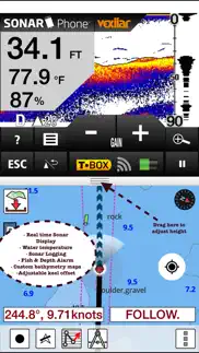
Fishing Points - Lake Maps Screenshots
Product details of Fishing Points - Lake Maps
- App Name:
- Fishing Points - Lake Maps
- App Version:
- 136.0.0
- Developer:
- Bist LLC
- Legitimacy Score:
- 88.4/100
- Safety Score:
- 88.9/100
- Content Rating:
- 4+ Contains no objectionable material!
- Category:
- Sports, Navigation
- Language:
- NL EN FI FR DE NB RU SV
- App Size:
- 49.48 MB
- Price:
- Free
- Bundle Id:
- com.skiracer.flmarinelite
- Relase Date:
- 07 March 2017, Tuesday
- Last Update:
- 28 June 2023, Wednesday - 08:22
- Compatibility:
- IOS 8.0 or later
- Fishing AI improvements: More details at https://www.gpsnauticalcharts.com/main/fishing-hot-spots-ai - Compiled with latest version of Xcode.