
- 81.2LEGITIMACY SCORE
- 81.7SAFETY SCORE
- 4+CONTENT RATING
- $25.99PRICE
What is I-Boating: Canada & USA - Marine / Nautical Navigation Charts for fishing & sailing? Description of I-Boating: Canada & USA - Marine / Nautical Navigation Charts for fishing & sailing 4065 chars
This App offers access to CHS marine vector & raster charts. First marine GPS app to have route assistance with Voice Prompts for marine navigation. You can create new boating routes or import existing GPX/KML routes. It supports Nautical Charts course up orientation. Includes Tide & Currents prediction.
(Includes coverage for Trent Severn Waterway incl. lake Simcoe etc.)
►FEATURES
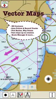
√ Beautiful and detailed Hardware/GPU accelerated vector charts (text stays upright on rotation)
√ Long press to query the details of Marine object (Buoy, Lights, Obstruction etc).
√ Customizable depth(Ft/Fathom/Meter) and distance units (km/mi/NM)
√ Customizable Shallow Depth.
√ Record tracks, Autofollow with real-time track overlay & predicted path vector.
√ Voice Prompts for marine navigation (requires GPS )
√ 1ft / 3ft depth contour maps for anglers for selected lake maps.
√ Supports GPX/KML for boating route editing/import.
√ Tide & Currents prediction.
√ Seamless chart quilting of marine charts
√ Enter or import Waypoints.
► MAPS
The maps include coverage of Pacific Coast, Central Canada(incl. Great Lakes, Trent Severn Waterway, Ontario Lakes), Atlantic coast derived from CHS data.
►ROUTE MANAGEMENT / TRIP PLANNING
√ Create New Route/Edit Existing Routes
√ Move Points
√ Add points to an existing route leg
√ Delete / Rename points
√ Import GPX, KML & KMZ files
√ Plot/Edit Routes
√ Enter Waypoints
√ Share/Export Routes, Tracks & Markers
√ Reverse Routes
►GPS FEATURES
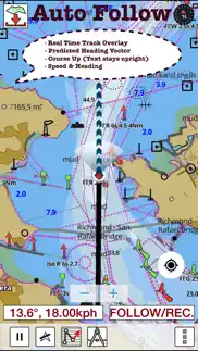
√ Auto Follow
* Real Time Track Overlay
* Predicted Path Vector
* Course Up (Text stays upright)
* Speed & Heading
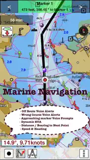
√ Route Assistance With Voice Prompts
* Prompts when approaching a boating route marker
* Continous distance and ETA updates
* Alerts when sailing/boating off route
* Alerts when boating in wrong direction
√ Record Tracks
►TIDE & CURRENTS
* For US, Canada, UK, Germany & New Zealand
* High/Low Tides
* Tidal Current Prediction
* Active Current Stations
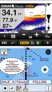
►Instrumentation
√ Marine AIS & (NMEA AIS and GPS over TCP/UDP)
√ Wind direction & Speed,Sonar depth,Water temperature
► SHARING
* Share tracks/routes/markers on Facebook & Twitter
* Export tracks/routes/markers as compressed GPX files.
Sample Nautical Charts
►Rainy Lake and Lake of the Woods
►Quebec to Anticosti Island West
►Gulf of St. Lawrence South
►Ontario Lakes
►Trent-Severn Waterway
►Labrador Coast
►Lac Saint Jean
►Rideau Canal - Ottawa River
►Georgian Bay
►Newfoundland East and South
►Great lakes Canada and St. Lawrence river
►Lakes and Rivers in Manitoba and Saskatchewan
►Lakes and Rivers of British Columbia
►Pacific Coast - Vancouver Island East & West - Haida Gwaii
►Lakes around Georgian Bay
►Gulf of St. Lawrence North - Newfoundland West
►Alberta Lakes
►Nova Scotia South - Bay of Fundy
Vancouver Island Ile de Vancouver, Juan de Fuca Strait Queen Charlotte Sound
Strait of Georgia, Southern Portion Partie Sud
Lake Ontario Lac Ontario
LAKE SIMCOE
Strait of Georgia, Central Portion Partie Centrale
BIG CHUTE MARINE RAILWAYS BER ROULANT
Strait of Georgia, Northern Portion Partie Nord
Georgian Bay Baie Georgienne
Strait of Georgia, Central Portion Partie Centrale
North Pender Island to a Thetis Island
Thetis Island to a Nanaimo
Juan de Fuca Strait to a Strait of Georgia
Howe Sound
Active Pass
Nanaimo Harbour and et Departure Bay
LAKE ROSSEAU AND/ET LAKE JOSEPH
Haro Strait, Boundary Pass and et Satellite Channel
Approaches to Approches a Vancouver Harbour
Vancouver Harbour, Western Portion Partie Ouest
Telegraph Harbour and et Preedy Harbour
Ganges Harbour and et Long Harbour
Dodd Narrows to a Flat Top Islands
Baynes Sound
Approaches to Approches a Sidney
Desolation Sound and et Sutil Channel
Porlier Pass
Fraser River Fleuve Fraser, Strait of Georgia Mitchell Island
Fraser River
Battery Disclaimer: Continued use of GPS running in the background can dramatically decrease battery life.
- I-Boating: Canada & USA - Marine / Nautical Navigation Charts for fishing & sailing App User Reviews
- I-Boating: Canada & USA - Marine / Nautical Navigation Charts for fishing & sailing Pros
- I-Boating: Canada & USA - Marine / Nautical Navigation Charts for fishing & sailing Cons
- Is I-Boating: Canada & USA - Marine / Nautical Navigation Charts for fishing & sailing legit?
- Should I download I-Boating: Canada & USA - Marine / Nautical Navigation Charts for fishing & sailing?
- I-Boating: Canada & USA - Marine / Nautical Navigation Charts for fishing & sailing Screenshots
- Product details of I-Boating: Canada & USA - Marine / Nautical Navigation Charts for fishing & sailing
I-Boating: Canada & USA - Marine / Nautical Navigation Charts for fishing & sailing App User Reviews
What do you think about I-Boating: Canada & USA - Marine / Nautical Navigation Charts for fishing & sailing app? Ask the appsupports.co community a question about I-Boating: Canada & USA - Marine / Nautical Navigation Charts for fishing & sailing!
Please wait! Facebook I-Boating: Canada & USA - Marine / Nautical Navigation Charts for fishing & sailing app comments loading...
I-Boating: Canada & USA - Marine / Nautical Navigation Charts for fishing & sailing Pros
✓ Great appSo much more defined than the chip. Some areas are not the same but hard to get all contours correct.Version: 60.0.0
✓ I-Boating: Canada & USA - Marine / Nautical Navigation Charts for fishing & sailing Positive ReviewsI-Boating: Canada & USA - Marine / Nautical Navigation Charts for fishing & sailing Cons
✗ Terrible - no informationThis app is awful. They tell you there is information for the specific lakes and then after you buy it you find out there is nothing. For the lakes there is some info they just scanned government provided documents. Not sure how this app is worth $2 let alone $35..Version: 60.0.0
✗ Tried it!This product is awful. Don't waste your time and money. Chart detail is lacking and not safe for navigation. I thought I could saVe a little money compared to Navionics. Big mistake! The only thing I'd like is my money back!.Version: 60.0.0
✗ I-Boating: Canada & USA - Marine / Nautical Navigation Charts for fishing & sailing Negative ReviewsIs I-Boating: Canada & USA - Marine / Nautical Navigation Charts for fishing & sailing legit?
✅ Yes. I-Boating: Canada & USA - Marine / Nautical Navigation Charts for fishing & sailing is 100% legit to us. This conclusion was arrived at by running over 19 I-Boating: Canada & USA - Marine / Nautical Navigation Charts for fishing & sailing user reviews through our NLP machine learning process to determine if users believe the app is legitimate or not. Based on this, AppSupports Legitimacy Score for I-Boating: Canada & USA - Marine / Nautical Navigation Charts for fishing & sailing is 81.2/100.
Is I-Boating: Canada & USA - Marine / Nautical Navigation Charts for fishing & sailing safe?
✅ Yes. I-Boating: Canada & USA - Marine / Nautical Navigation Charts for fishing & sailing is quiet safe to use. This is based on our NLP analysis of over 19 user reviews sourced from the IOS appstore and the appstore cumulative rating of 4.1/5. AppSupports Safety Score for I-Boating: Canada & USA - Marine / Nautical Navigation Charts for fishing & sailing is 81.7/100.
Should I download I-Boating: Canada & USA - Marine / Nautical Navigation Charts for fishing & sailing?
✅ There have been no security reports that makes I-Boating: Canada & USA - Marine / Nautical Navigation Charts for fishing & sailing a dangerous app to use on your smartphone right now.
I-Boating: Canada & USA - Marine / Nautical Navigation Charts for fishing & sailing Screenshots
Product details of I-Boating: Canada & USA - Marine / Nautical Navigation Charts for fishing & sailing
- App Name:
- I-Boating: Canada & USA - Marine / Nautical Navigation Charts for fishing & sailing
- App Version:
- 60.0.0
- Developer:
- Bist LLC
- Legitimacy Score:
- 81.2/100
- Safety Score:
- 81.7/100
- Content Rating:
- 4+ Contains no objectionable material!
- Category:
- Navigation, Travel
- Language:
- NL EN FI FR DE NB RU SV
- App Size:
- 51.23 MB
- Price:
- $25.99
- Bundle Id:
- com.skiracer.camarinevec
- Relase Date:
- 03 August 2015, Monday
- Last Update:
- 22 June 2016, Wednesday - 23:20
- Compatibility:
- IOS 7.0 or later
This app has been updated by Apple to display the Apple Watch app icon. ►Instrumentation √ Marine AIS & (NMEA AIS and GPS over TCP/UDP) √ Wind direction & Speed,Sonar depth,Water temperature ►Support for Aerial Imagery, Regular Street maps.