
- 81.1LEGITIMACY SCORE
- 85.6SAFETY SCORE
- 4+CONTENT RATING
- FreePRICE
What is I-Boating: Marine Charts & Gps? Description of I-Boating: Marine Charts & Gps 4114 chars
This App offers access to Marine Charts for USA,Canada,UK/Ireland,Germany,Netherlands/Holland &
Europe Rivers (Danube,Drava,Rhein etc). Coverage includes NOAA marine vector
charts,freshwater lake maps,USACE inland river maps (HD/1ft/3ft bathymetry
included where available),charts derived from UKHO & CHS data. First marine GPS app to have route assistance with Voice Prompts for marine navigation. You can create new boating routes or import existing GPX/KML routes. It supports Nautical Charts course up orientation. Includes Tide & Currents prediction.
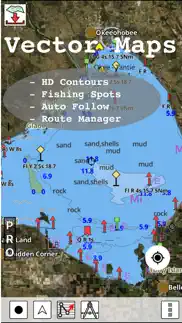
►FEATURES
√ Beautiful & detailed Hardware/GPU accelerated vector charts (text stays upright on rotation)
√ Long press to query the details of Marine object (Buoy,Lights,Obstruction etc).
√ Customizable depth(Ft/Fathom/Meter) & distance units(km/mi/NM)
√ Customizable Shallow Depth.
√ Record tracks,Autofollow with real-time track overlay & predicted path vector.
√ Voice Prompts for marine navigation (requires GPS )
√ 1ft / 3ft depth contour maps for anglers for selected lake maps.
√ Supports GPX/KML for boating route editing/import.
√ Tide & Currents prediction.
√ Seamless chart quilting of marine charts
√ Enter or import Waypoints.
► MAPS
It includes unlimited updates for 1 year.
√USA: The maps include coverage of all NOAA marine vector charts (ENC),USACE inland river maps,freshwater lake maps for more than 7K lakes. The charts include HD/1ft/3ft bathymetry where available.Incl. NOAA raster where ENC not available.
√Canada:Incl. CHS data(incl. major Lakes).
√UK/Ireland: Derived from UKHO charts.
√Australia
√Germany: derived from BSH data
√Europe Inland Rivers:Donau/Dunaja,Rhine,Garonne,Moselle,Drava,Sava,etc
√Norway
√Finland
√Sweden
√Croatia
√Ukraine(Black Sea)
√Caribbean
√New Zealand
√Spain
√Brazil
√Argentina
√Cyprus
√Falklands
√Seychelles& Mauritius
√Denmark
√Malta,Cyprus & S. Mediterranean
√S. China&Malaysia
√South Africa
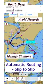
►ROUTE MANAGEMENT / TRIP PLANNING
√ Create New Route/Edit Existing Routes
√ Move Points
√ Add points to an existing route leg
√ Delete / Rename points
√ Import GPX,KML & KMZ files
√ Plot/Edit Routes
√ Enter Waypoints
√ Share/Export Routes,Tracks&Markers
√ Reverse Routes
►SLIP TO SLIP AUTO ROUTING
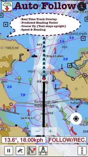
►GPS FEATURES
√ Auto Follow
* Real Time Track Overlay
* Predicted Path Vector
* Course Up(Text stays upright)
* Speed & Heading
√ Route Assistance With Voice Prompts
* Prompts when approaching a boating route marker
* Continous distance & ETA updates
* Alerts when sailing/boating off route
* Alerts when boating in wrong direction
√ Record Tracks
►TIDE & CURRENTS
* For US,Canada,UK,Germany & New Zealand
* High/Low Tides
* Tidal Current Prediction
* Active Current Stations
►Instrumentation
√ Marine AIS & (NMEA AIS and GPS over TCP/UDP)
√ Wind direction & Speed,Marine Sonar depth,Water temperature
√ Auto Pilot
► SHARING
* Share tracks/routes/markers on Facebook & Twitter
* Export tracks/routes/markers as GPX files.
SUGARLOAF KEY-KEY WEST
PORT RICHEY TAMPA BAY - CLEARWATER HBR
EAST BAY-WEST BAY FLORIDA
INTRACOASTAL WATERWAY MATECUMBE-GRASSY KEY
CHESAPEAKE BAY CAPE CHARLES-NORFOLK HARBOR
ANCLOTE KEYS-CRYSTAL RIVER
ST JOSEPH SOUND
MIAMI HARBOR
Minnesota lakes - Kabetogama,Minnetonka,Waconia,Leech,Mille Lacs
Lake Keowee,Jocassee,Hartwell,Greenwood,Lake Murray
Mark Twain,Ozarks,Table Rock
Lake St.Clair
Lake Kentucky
KEY WEST-THE MISSISSIPPI RIVER
SAN PEDRO CHANNEL
LAKE MICHIGAN STONY LAKE-POINT BETSIE
APALACHICOLA BAY-CAPE SAN BLAS
EAST CAPE-MORMON KEY
CAPE HENLOPEN-INDIAN RIVER
CHESAPEAKE BAY CAPE HENRY-THIMBLE SHOAL
DULUTH-SUPERIOR
MONHEGAN ISLAND-CAPE ELIZABETH
ONTARIO - CLAYTON-FALSE DUCKS
Winnipesaukee
MIAMI-MARATHON,FLORIDA
CAPE MAY-FENWICK ISLAND
MISSISSIPPI RIVER-GALVESTON
CAPE CANAVERAL-KEY
DELAWARE RIVER WILMINGTON-PHILADELPHIA
FLORIDA KEYS SOMBRERO KEY-SAND KEY
SAN PABLO BAY
RAINY LAKE BIG ISLAND MINN-OAKPOINT
INTRACOASTAL WATERWAY-BISCAYNE BAY
EVERGLADES NTL PARK
HURON
TAHOE
CHESAPEAKE DELAWARE CANAL
BACKGROUND GPS CAN DECREASE BATTERY LIFE
- I-Boating: Marine Charts & Gps App User Reviews
- I-Boating: Marine Charts & Gps Pros
- I-Boating: Marine Charts & Gps Cons
- Is I-Boating: Marine Charts & Gps legit?
- Should I download I-Boating: Marine Charts & Gps?
- I-Boating: Marine Charts & Gps Screenshots
- Product details of I-Boating: Marine Charts & Gps
I-Boating: Marine Charts & Gps App User Reviews
What do you think about I-Boating: Marine Charts & Gps app? Ask the appsupports.co community a question about I-Boating: Marine Charts & Gps!
Please wait! Facebook I-Boating: Marine Charts & Gps app comments loading...
I-Boating: Marine Charts & Gps Pros
✓ Not badAll of the Bathymetric maps are good. The interesting part is the space around the Maps; unless I am missing it there is no base layer map of the land associated with it, which make searching a bit tougher but doable. Also I’m left to wonder how many bodies of water have been mapped, and if so are all of those on here. I live in an area that has quite a few lakes around it but it seems like there’s some that are missing, although I don’t know if it is an issue from these ever been mapped. i’ve only use this product so I can’t compare it against others..Version: 126.0.0
✓ SuperbI find this a great app to use for sea fishing..Version: 110.0.0
✓ I-Boating: Marine Charts & Gps Positive ReviewsI-Boating: Marine Charts & Gps Cons
✗ No customer serviceI’m new to chart plotters on my phone, and am beginning to regret buying i-boating rather than one of the other more popular apps. Every time I open the app it tells me there are no maps loaded and demands I buy some. This despite my having bought the UK Ireland Netherlands and France folio. So I tried to contact Customer Service to ask why, and how to resolve the issue. Forget it - there is no way to contact them..Version: 135.0.0
✗ Just purchasedNot that easy to use would like my money back.Version: 110.0.0
✗ I-Boating: Marine Charts & Gps Negative ReviewsIs I-Boating: Marine Charts & Gps legit?
✅ Yes. I-Boating: Marine Charts & Gps is 100% legit to us. This conclusion was arrived at by running over 11,099 I-Boating: Marine Charts & Gps user reviews through our NLP machine learning process to determine if users believe the app is legitimate or not. Based on this, AppSupports Legitimacy Score for I-Boating: Marine Charts & Gps is 81.1/100.
Is I-Boating: Marine Charts & Gps safe?
✅ Yes. I-Boating: Marine Charts & Gps is quiet safe to use. This is based on our NLP analysis of over 11,099 user reviews sourced from the IOS appstore and the appstore cumulative rating of 4.5/5. AppSupports Safety Score for I-Boating: Marine Charts & Gps is 85.6/100.
Should I download I-Boating: Marine Charts & Gps?
✅ There have been no security reports that makes I-Boating: Marine Charts & Gps a dangerous app to use on your smartphone right now.
I-Boating: Marine Charts & Gps Screenshots

Product details of I-Boating: Marine Charts & Gps
- App Name:
- I-Boating: Marine Charts & Gps
- App Version:
- 139.0.0
- Developer:
- Bist LLC
- Legitimacy Score:
- 81.1/100
- Safety Score:
- 85.6/100
- Content Rating:
- 4+ Contains no objectionable material!
- Category:
- Navigation, Travel
- Language:
- NL EN FI FR DE NB RU SV
- App Size:
- 49.20 MB
- Price:
- Free
- Bundle Id:
- com.skiracer.gpsnauticalchartslite
- Relase Date:
- 30 May 2015, Saturday
- Last Update:
- 17 January 2024, Wednesday - 22:08
- Compatibility:
- IOS 8.0 or later
Major Update: Lake Temperature Maps: Identify Fishing Hot Spots using Thermoclines accurate to 1°F (0.5° C)..