

- 14.0LEGITIMACY SCORE
- 17.0SAFETY SCORE
- 4+CONTENT RATING
- $39.99PRICE
What is Marine Navigation UK Ireland? Description of Marine Navigation UK Ireland 3747 chars
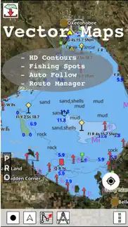
GPS Nautical Charts App offers access to RNC charts covering United Kingdom / Ireland waters (derived from UKHO data) with POI layers created from ENC charts. Only marine GPS app to have route assistance with Voice Prompts for marine navigation. It has route manager to create new boating routes or import existing GPX/KML routes. It supports Nautical Charts course up orientation.
Please visit http://www.gpsnauticalcharts.com/main/uk-nautical-charts-by-folio.html for complete list. If you don't find the chart for United Kingdom / Ireland, please contact us at support at gpsnauticalcharts.com.
* Voice Prompts for marine navigation (requires GPS )
-prompts when approaching a boating route marker
-Continous distance and ETA updates
-Alerts when sailing/boating off route
-Alerts when boating in wrong direction
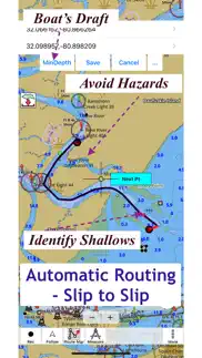
*Route Editing/Creation
-Create routes from scratch
-Edit existing GPX/KML routes.
-Add custom description to any route point.
-Drop markers along route.
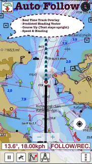
*Real time track overlay with projected heading vector
►SLIP TO SLIP AUTO ROUTING
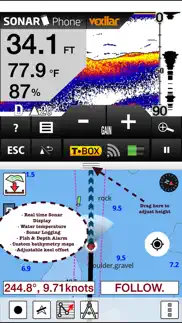
►Instrumentation
√ Marine AIS & (NMEA AIS and GPS over TCP/UDP)
√ Wind direction & Speed,Marine Sonar depth,Water temperature
* Offline charts derived from UKHO data.
-Visually draw area to download
-Textual search
-Catalog (By state, region and coast guard district)
-Charts reprojected for WGS84 datum
*Seamless chart quilting of marine charts
*Distance Bearing tool
*Create custom way points
- Using GPS
-Select point on map
-Manually enter latitude & longitude coordinates
*Search POIs/Way points
*Tidal Prediction
*Pan/Zoom/My Location
* Record Marine GPS tracks
* View tracks overlay
* Live track animation
* Track analytics/stats
* Export GPX tracks.
-Export to SDCard
-Share GPX trakcs with friends.
* Auto Follow Mode (Course up)
-Continuously updates boat's location on chart
- Adjustable update frequency
Sample Nautical Charts (please visit http://www.gpsnauticalcharts.com/main/uk-nautical-charts-by-folio.html for complete list)
The Solent and Southampton Water
A Beaulieu River
Western Approaches to The Solent
Approaches to Portsmouth
Bill of Portland to the Needles
Bill of Portland to Anvil Point
Eastern Approaches to the Solent
G Lymington River
A Continuation of River Medina
Southampton Water and Approaches
Outer Approaches to the Solent
Port of Southampton
Selsey Bill to Beachy Head
Approaches to Portland and Weymouth
Cowes Harbour and River Medina
Berry Head to Bill of Portland
Entrance to River Hamble
Thames Estuary
B River Medina Folly Point to Newport
Portsmouth Harbour
Ashlett Creek
Yarmouth Harbour
Approaches to Keyhaven
Alum Bay
Newtown River
Approaches to Felixstowe, Harwich and Ipswich with the Rivers Stour, Orwell and Deben
Falmouth to Plymouth
G Hillhead Harbour
Dartmouth Harbour
Poole Harbour and Approaches
Poole Bay
Falmouth to Truro
B Upper Reaches of Beaulieu River
Continuation of Fareham Lake
River Yar
Wootton Creek
Langstone and Chichester Harbours
Lyme Regis Harbour
Brighton Marina
Land's End to Falmouth
Portsmouth Harbour Southern Part
Bembridge Harbour
Continuation of Holes Bay
Eddystone Rocks to Berry Head
Approaches to Padstow
Thames Estuary Northern Part
Freshwater Bay
Helford River Continuation to Gweek
Tor Bay
Portsmouth Harbour Northern Part
Lizard Point
Continuation to Port Solent
Start Point to Brixham
Continuation to Blackness Point
Newquay Bay
Salcombe to Start Point
Charlestown Harbour
Portland Harbour
River Thames Sea Reach
Penzance Bay
Caernarfon Bay
Bristol Channel
Mevagissey
Linney Head to Oxwich Point
Salcombe Harbour
Harwich and Felixstowe
Salcombe
Approaches to Falmouth
Par Harbour
- Marine Navigation UK Ireland App User Reviews
- Marine Navigation UK Ireland Pros
- Marine Navigation UK Ireland Cons
- Is Marine Navigation UK Ireland legit?
- Should I download Marine Navigation UK Ireland?
- Marine Navigation UK Ireland Screenshots
- Product details of Marine Navigation UK Ireland
Marine Navigation UK Ireland App User Reviews
What do you think about Marine Navigation UK Ireland app? Ask the appsupports.co community a question about Marine Navigation UK Ireland!
Please wait! Facebook Marine Navigation UK Ireland app comments loading...
Marine Navigation UK Ireland Pros
✓ Fab app for The priceI have used it to navigate my sailing boat by iPad all round Scotland, Hebrides and the Orkneys. Love it. Hope it's legal..Version: 19.0.0
✓ Marine Navigation UK Ireland Positive ReviewsMarine Navigation UK Ireland Cons
✗ Slow loading of charts hampers functionalityA high price to pay bearing in mind how many other very good nav apps there are. Each chart takes an age to load into memory initially, and I had to start loading them individually because the app said my cruising area had too many charts to load concurrently. With this app that is MY problem. The only alternative is to load charts one at a time. Further, there are some rather bizarre situations where the map will only mesh together and display charts of the same scale, and so there are acres of area marked as 'cannot display at this scale'. Charts are not organised into same-scale sets either and loading a complete set at any particular scale is a hit and miss affair using the available chart list. The downloading of charts is not very user friendly. I shall buy a folio set of paper charts covering my cruising area to log my voyage progress at the chart table. Going all-electronic goes against marine common sense, but in any case if I had to choose one electronic charting app it would not be this one..Version: 19.0.0
✗ Marine Navigation UK Ireland Negative ReviewsIs Marine Navigation UK Ireland legit?
Marine Navigation UK Ireland scam ~ legit report is not ready. Please check back later.
Is Marine Navigation UK Ireland safe?
Marine Navigation UK Ireland safe report is not ready. Please check back later.
Should I download Marine Navigation UK Ireland?
Marine Navigation UK Ireland download report is not ready. Please check back later.
Marine Navigation UK Ireland Screenshots
Product details of Marine Navigation UK Ireland
- App Name:
- Marine Navigation UK Ireland
- App Version:
- 122.0.0
- Developer:
- Bist LLC
- Legitimacy Score:
- 14.0/100
- Safety Score:
- 17.0/100
- Content Rating:
- 4+ Contains no objectionable material!
- Category:
- Travel, Navigation
- Language:
- NL EN FI FR DE NB RU SV
- App Size:
- 61.73 MB
- Price:
- $39.99
- Bundle Id:
- com.skiracer.gbrmarine
- Relase Date:
- 09 August 2013, Friday
- Last Update:
- 18 June 2022, Saturday - 14:40
- Compatibility:
- IOS 8.0 or later
-Compiled with latest version of Xcode - Auto Routing Support - Wind Speed & Direction Overlay - Tidal Stream support (incl. offline support for GB stations) - Magnetic Bearing Support - Inland lakes Support - Night Mode - NMEA Support (AIS target o....