
- 77.2LEGITIMACY SCORE
- 81.7SAFETY SCORE
- 4+CONTENT RATING
- $22.99PRICE
What is I-Boating: USA Marine Charts? Description of I-Boating: USA Marine Charts 4007 chars
This App offers access to NOAA marine vector charts, freshwater lake maps, USACE inland river maps (HD/1ft/3ft bathymetry included where available). First marine GPS app to have route assistance with Voice Prompts for marine navigation. You can create new boating routes or import existing GPX/KML routes. It supports Nautical Charts course up orientation. Includes Tide & Currents prediction.
►FEATURES
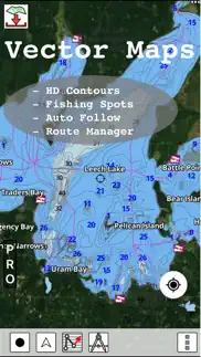
√ Beautiful and detailed Hardware/GPU accelerated vector charts (text stays upright on rotation)
√ Long press to query the details of Marine object (Buoy, Lights, Obstruction etc).
√ Customizable depth(Ft/Fathom/Meter) and distance units (km/mi/NM)
√ Customizable Shallow Depth.
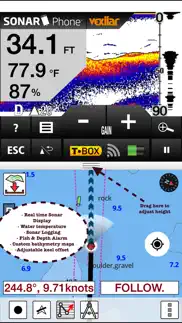
√ Record tracks, Autofollow with real-time track overlay & predicted path vector.
√ Voice Prompts for marine navigation (requires GPS )
√ 1ft / 3ft depth contour maps for anglers for selected lake maps.
√ Supports GPX/KML for boating route editing/import.
√ Tide & Currents prediction.
√ Seamless chart quilting of marine charts
√ Enter or import Waypoints.
► MAPS
The maps include coverage of all NOAA marine vector charts (ENC), USACE inland river maps, and freshwater lake maps for more than 7K lakes. The charts include HD/1ft/3ft bathymetry where available. The app also includes NOAA raster charts for some areas where NOAA ENC coverage is not available. It includes unlimited updates for 1 year.
►ROUTE MANAGEMENT / TRIP PLANNING
√ Create New Route/Edit Existing Routes
√ Move Points
√ Add points to an existing route leg
√ Delete / Rename points
√ Import GPX, KML & KMZ files
√ Plot/Edit Routes
√ Enter Waypoints
√ Share/Export Routes, Tracks & Markers
√ Reverse Routes
►GPS FEATURES
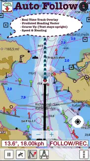
√ Auto Follow
* Real Time Track Overlay
* Predicted Path Vector
* Course Up (Text stays upright)
* Speed & Heading
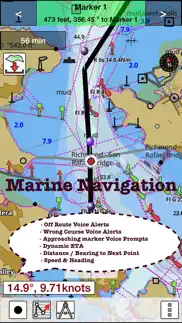
√ Route Assistance With Voice Prompts
* Prompts when approaching a boating route marker
* Continous distance and ETA updates
* Alerts when sailing/boating off route
* Alerts when boating in wrong direction
√ Record Tracks
►TIDE & CURRENTS
* For US, Canada, UK, Germany & New Zealand
* High/Low Tides
* Tidal Current Prediction
* Active Current Stations
► SHARING
* Share tracks/routes/markers on Facebook & Twitter
* Export tracks/routes/markers as compressed GPX files.
Sample Nautical Charts (please visit http://gpsnauticalcharts.com/main/folio-catalog-nautical-charts-app for complete list)
SUGARLOAF KEY-KEY WEST
PORT RICHEY TAMPA BAY - CLEARWATER HBR
EAST BAY-WEST BAY FLORIDA
ST JOSEPH, ST ANDREW BAYS
INTRACOASTAL WATERWAY MATECUMBE-GRASSY KEY
CHESAPEAKE BAY CAPE CHARLES-NORFOLK HARBOR
ANCLOTE KEYS-CRYSTAL RIVER
ST JOSEPH SOUND
MIAMI HARBOR
Minnesota lakes - Kabetogama, Minnetonka, Waconia,Leech,Mille Lacs
Lake Keowee,Jocassee,Hartwell,Greenwood,Lake Murray
Mark Twain,Ozarks,Table Rock
Lake St. Clair
Lake Kentucky
KEY WEST-THE MISSISSIPPI RIVER
SAN PEDRO CHANNEL
LAKE MICHIGAN STONY LAKE-POINT BETSIE
APALACHICOLA BAY-CAPE SAN BLAS
EAST CAPE-MORMON KEY
CAPE HENLOPEN-INDIAN RIVER INLET
CHESAPEAKE BAY CAPE HENRY-THIMBLE SHOAL LIGHT
DULUTH-SUPERIOR HARBOR
MONHEGAN ISLAND-CAPE ELIZABETH
LAKE ONTARIO - CLAYTON-FALSE DUCKS ISL
Lake Winnipesaukee
SAN FRANCISCO ENTRANCE
MIAMI-MARATHON, FLORIDA BAY
CAPE MAY-FENWICK ISLAND
MISSISSIPPI RIVER-GALVESTON
CAPE CANAVERAL-KEY WEST
DELAWARE RIVER WILMINGTON-PHILADELPHIA
FLORIDA KEYS SOMBRERO KEY-SAND KEY
SAN PABLO BAY
RAINY LAKE BIG ISLAND MINN-OAKPOINT ISL ONT
INTRACOASTAL WATERWAY - BISCAYNE BAY
EVERGLADES NTL PARK - SHARK RVR-LOSTMANS RVR
MIAMI-MARATHON & FLORIDA BAY
BLACKBURN BAY
LAKE HURON
LAKE TAHOE
STRAITS OF MACKINAC
NORFOLK HARBOR & ELIZABETH RIVER
SAN DIEGO-SANTA ROSA ISLAND
DELAWARE BAY
CHOPTANK RIVER CAMBRIDGE-GREENSBORO
FORT LAUDERDALE PORT EVERGLADES
ST SIMONS SOUND-TOLOMATO RIVER
CHESAPEAKE DELAWARE CANAL
PLEASE NOTE: Continued use of GPS running in the background can dramatically decrease battery life.
- I-Boating: USA Marine Charts App User Reviews
- I-Boating: USA Marine Charts Pros
- I-Boating: USA Marine Charts Cons
- Is I-Boating: USA Marine Charts legit?
- Should I download I-Boating: USA Marine Charts?
- I-Boating: USA Marine Charts Screenshots
- Product details of I-Boating: USA Marine Charts
I-Boating: USA Marine Charts App User Reviews
What do you think about I-Boating: USA Marine Charts app? Ask the appsupports.co community a question about I-Boating: USA Marine Charts!
Please wait! Facebook I-Boating: USA Marine Charts app comments loading...
I-Boating: USA Marine Charts Pros
✓ Great AppThe App worked flawlessly for a 400+ mile trip around Florida..Version: 50.0.0
✓ Excellent small boat charting option!Moved recently from Florida to Utah. Have encountered a number of nautical challenges transitioning from coastal chart plotter navigation to inland lakes navigation. Garmin & Lowrance both want a fortune for their chart plotter options in both inland and coastal products. This i-boating USA app. Provides fabulous detail on both coastal and inland options for a very, very reasonable price point. Awesome option alternative to big boy price gouging for marine navigation..Version: 107.0.0
✓ I-Boating: USA Marine Charts Positive ReviewsI-Boating: USA Marine Charts Cons
✗ Very difficult to creat a new routeVery difficult to creat a new route.Version: 92.0.0
✗ Waste of moneyWay to hard to figure out. Not helpful at all - not worth the money and wish I could get a refund.Version: 60.0.0
✗ I-Boating: USA Marine Charts Negative ReviewsIs I-Boating: USA Marine Charts legit?
✅ Yes. I-Boating: USA Marine Charts is legit, but not 100% legit to us. This conclusion was arrived at by running over 271 I-Boating: USA Marine Charts user reviews through our NLP machine learning process to determine if users believe the app is legitimate or not. Based on this, AppSupports Legitimacy Score for I-Boating: USA Marine Charts is 77.2/100.
Is I-Boating: USA Marine Charts safe?
✅ Yes. I-Boating: USA Marine Charts is quiet safe to use. This is based on our NLP analysis of over 271 user reviews sourced from the IOS appstore and the appstore cumulative rating of 4.3/5. AppSupports Safety Score for I-Boating: USA Marine Charts is 81.7/100.
Should I download I-Boating: USA Marine Charts?
✅ There have been no security reports that makes I-Boating: USA Marine Charts a dangerous app to use on your smartphone right now.
I-Boating: USA Marine Charts Screenshots
Product details of I-Boating: USA Marine Charts
- App Name:
- I-Boating: USA Marine Charts
- App Version:
- 107.0.0
- Developer:
- Bist LLC
- Legitimacy Score:
- 77.2/100
- Safety Score:
- 81.7/100
- Content Rating:
- 4+ Contains no objectionable material!
- Category:
- Navigation, Travel
- Language:
- NL EN FI FR DE NB RU SV
- App Size:
- 61.49 MB
- Price:
- $22.99
- Bundle Id:
- com.skiracer.usmarinevec
- Relase Date:
- 06 June 2015, Saturday
- Last Update:
- 27 May 2021, Thursday - 17:15
- Compatibility:
- IOS 8.0 or later
- Temporal Wind Prediction Overlay - Magnetic Bearing - New lakes covering Michigan, Minnesota, Florida - Compiled with latest version of Xcode.