

- 19.0LEGITIMACY SCORE
- 19.5SAFETY SCORE
- 4+CONTENT RATING
- $34.99PRICE
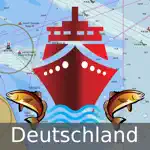
What is I-Boating:Germany Marine Chart? Description of I-Boating:Germany Marine Chart 2530 chars
This App offers access to marine vector covering German waters (derived from BSH data). First marine GPS app to have route assistance with Voice Prompts for marine navigation. You can create new boating routes or import existing GPX/KML routes. It supports Nautical Charts course up orientation. Includes Tide & Currents prediction.
►FEATURES
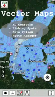
√ Beautiful and detailed Hardware/GPU accelerated vector charts (text stays upright on rotation)
√ Long press to query the details of Marine object (Buoy, Lights, Obstruction etc).
√ Customizable depth(Ft/Fathom/Meter) and distance units (km/mi/NM)
√ Customizable Shallow Depth.
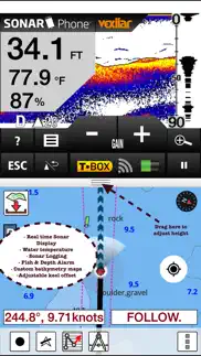
√ Record tracks, Autofollow with real-time track overlay & predicted path vector.
√ Voice Prompts for marine navigation (requires GPS )
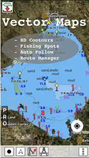
√ 1ft / 3ft depth contour maps for anglers for selected lake maps.
√ Supports GPX/KML for boating route editing/import.
√ Tide & Currents prediction.
√ Seamless chart quilting of marine charts
√ Enter or import Waypoints.
► MAPS
The maps include coverage of Germany (both coastal and inland waters) (derived from BSH data).
►ROUTE MANAGEMENT / TRIP PLANNING
√ Create New Route/Edit Existing Routes
√ Move Points
√ Add points to an existing route leg
√ Delete / Rename points
√ Import GPX, KML & KMZ files
√ Plot/Edit Routes
√ Enter Waypoints
√ Share/Export Routes, Tracks & Markers
√ Reverse Routes
►GPS FEATURES
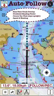
√ Auto Follow
* Real Time Track Overlay
* Predicted Path Vector
* Course Up (Text stays upright)
* Speed & Heading
√ Route Assistance With Voice Prompts
* Prompts when approaching a boating route marker
* Continous distance and ETA updates
* Alerts when sailing/boating off route
* Alerts when boating in wrong direction
√ Record Tracks
►TIDE & CURRENTS
* For US, Canada, UK, Germany & New Zealand
* High/Low Tides
* Tidal Current Prediction
* Active Current Stations
► SHARING
* Share tracks/routes/markers on Facebook & Twitter
* Export tracks/routes/markers as compressed GPX files.
Sample Nautical Charts (please visit http://gpsnauticalcharts.com/main/de-nautical-charts-by-folio.html)
►Dysentery
►Berlin-Spandau navigation canal
►Spree-Oder Waterway
►Rhine-Herne Canal
►Wesel-Datteln Canal
►Elbe-Havel Canal
►Lower Havel Waterway (Spandau - Plaue)
►Saar
►Dortmund-Ems Canal
►Elbe Lateral Canal
►Weser
►Rhine-Main-Danube Canal
►Havel-Oder Waterway
►West Or
►Neckar
►Danube
►Moselle
►Mittellandkanal
►Main
►North Sea
►Rhine
►Elbe
►Baltic Sea
- I-Boating:Germany Marine Chart App User Reviews
- I-Boating:Germany Marine Chart Pros
- I-Boating:Germany Marine Chart Cons
- Is I-Boating:Germany Marine Chart legit?
- Should I download I-Boating:Germany Marine Chart?
- I-Boating:Germany Marine Chart Screenshots
- Product details of I-Boating:Germany Marine Chart
I-Boating:Germany Marine Chart App User Reviews
What do you think about I-Boating:Germany Marine Chart app? Ask the appsupports.co community a question about I-Boating:Germany Marine Chart!
Please wait! Facebook I-Boating:Germany Marine Chart app comments loading...
I-Boating:Germany Marine Chart Pros
The pros of the I-Boating:Germany Marine Chart application were not found.
✓ I-Boating:Germany Marine Chart Positive ReviewsI-Boating:Germany Marine Chart Cons
The cons of the I-Boating:Germany Marine Chart application were not found.
✗ I-Boating:Germany Marine Chart Negative ReviewsIs I-Boating:Germany Marine Chart legit?
I-Boating:Germany Marine Chart scam ~ legit report is not ready. Please check back later.
Is I-Boating:Germany Marine Chart safe?
I-Boating:Germany Marine Chart safe report is not ready. Please check back later.
Should I download I-Boating:Germany Marine Chart?
I-Boating:Germany Marine Chart download report is not ready. Please check back later.
I-Boating:Germany Marine Chart Screenshots
Product details of I-Boating:Germany Marine Chart
- App Name:
- I-Boating:Germany Marine Chart
- App Version:
- 114.0.0
- Developer:
- Bist LLC
- Legitimacy Score:
- 19.0/100
- Safety Score:
- 19.5/100
- Content Rating:
- 4+ Contains no objectionable material!
- Category:
- Travel, Navigation
- Language:
- NL EN FI FR DE NB RU SV
- App Size:
- 61.91 MB
- Price:
- $34.99
- Bundle Id:
- com.skiracer.demarinevec
- Relase Date:
- 05 November 2015, Thursday
- Last Update:
- 16 March 2022, Wednesday - 19:55
- Compatibility:
- IOS 8.0 or later
- Anchor alarm support - Compiled with latest version of Xcode.