

- 19.0LEGITIMACY SCORE
- 19.5SAFETY SCORE
- 4+CONTENT RATING
- $2.99PRICE
What is Texas – Raster Nautical Charts? Description of Texas – Raster Nautical Charts 2018 chars
THE ALL NEW ADVANCED MARINE RASTER NAUTICAL CHARTS APP FOR BOATERS AND SAILORS!
THIS MAP PROVIDES ALL THE NECESSARY TOOLS FOR EASY NAVIGATION ON WATER. CONTINUOUS CHARTS DISPLAY MAKES IT MORE EASIER FOR SAILING AND AS THERE WILL BE NO INTERNET ON SEA, THIS CHART IS FASTER FOR NAVIGATION.
NO WAITING TIME FOR NAUTICAL CHART DOWNLOADS. READY TO USE, SEAMLESS FOR CONTINUOUS NAVIGATION!
COMBINATION OF COASTAL CHARTS, SMALL CRAFT AND HARBOR CHARTS FOR EASY NAVIGATION.
ALL CHARTS OVERLAY IS ARRANGED IN A SEAMLESS ORDER, BASED ON CHART SCALE AND PRIORITY.
NO NEED TO CHANGE CHARTS MANUALLY, THEY ARE READY FOR CONTINUOUS NAVIGATION.
● ALL MARINE RASTER NAUTICAL CHARTS ARE FROM NOAA SOURCES.
● ALL CHARTS ALIGNED WITH ORIGINAL CHART CO-ORDINATES, ARE ACCURATE FOR USE.
● GPS - SHOWS & UPDATES USER CURRENT LOCATION ON MAP.
● SEAMLESS CHART OVERLAY DISPLAY, USE THEM AS LONG AS YOU BOAT.
● HIDE AND SHOW CHART OVERLAY TO SEE DIFFERENCE IN AERIAL OR OTHER MAPS.
● INTERACTIVE COMPASS, MOVE AND PLACE ANYWHERE ON MAP SCREEN.
● KNOW ANY LOCATION COORDINATE WITH A SINGLE TAP.
● FIND DISTANCES WITH ROUTE TOOL, DRAW ON MAP AND NAVIGATE ALONG THE ROUTE.
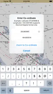
● GOTO MAP LOCATION BY ENTERING LATITUDE/LONGITUDE.
● INSERT UNLIMITED FAVOURITE MARKERS ON MAP. PHOTO TAGGED FACILITY FOR MARKERS WITH EMAIL OPTION. ADD MULTIPLE PHOTOS TO FAVOURITE MARKERS (MAX 3 ALLOWED). EMAIL FAVOURITE MARKERS AS KMZ FILE.
● MAP USER INFORMATION.
NOTE: All charts are Geo-positioned to match the exact location of features displayed on charts but there may be some difference between the positions of actual objects that are in the water or sea and charts because of the different chart scales.
Disclaimer: The Raster Nautical Charts data provided in all charts is from NOAA and is for reference purposes only and not for navigation.
We strive to provide the best products to the customers. Any suggestions from the users of this product are welcome to make the app more useful.
HAPPY BOATING AND SAILING ALL THE TIME!
- Texas – Raster Nautical Charts App User Reviews
- Texas – Raster Nautical Charts Pros
- Texas – Raster Nautical Charts Cons
- Is Texas – Raster Nautical Charts legit?
- Should I download Texas – Raster Nautical Charts?
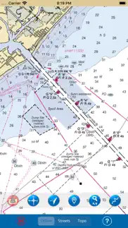
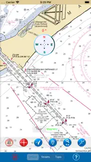
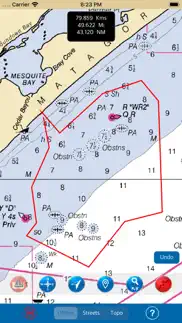
- Texas – Raster Nautical Charts Screenshots
- Product details of Texas – Raster Nautical Charts
Texas – Raster Nautical Charts App User Reviews
What do you think about Texas – Raster Nautical Charts app? Ask the appsupports.co community a question about Texas – Raster Nautical Charts!
Please wait! Facebook Texas – Raster Nautical Charts app comments loading...
Texas – Raster Nautical Charts Pros
The pros of the Texas – Raster Nautical Charts application were not found.
✓ Texas – Raster Nautical Charts Positive ReviewsTexas – Raster Nautical Charts Cons
The cons of the Texas – Raster Nautical Charts application were not found.
✗ Texas – Raster Nautical Charts Negative ReviewsIs Texas – Raster Nautical Charts legit?
Texas – Raster Nautical Charts scam ~ legit report is not ready. Please check back later.
Is Texas – Raster Nautical Charts safe?
Texas – Raster Nautical Charts safe report is not ready. Please check back later.
Should I download Texas – Raster Nautical Charts?
Texas – Raster Nautical Charts download report is not ready. Please check back later.
Texas – Raster Nautical Charts Screenshots
Product details of Texas – Raster Nautical Charts
- App Name:
- Texas – Raster Nautical Charts
- App Version:
- 3.5
- Developer:
- Vishwam B
- Legitimacy Score:
- 19.0/100
- Safety Score:
- 19.5/100
- Content Rating:
- 4+ Contains no objectionable material!
- Category:
- Navigation, Travel
- Language:
- EN
- App Size:
- 485.07 MB
- Price:
- $2.99
- Bundle Id:
- com.vishwam.TexasRaster
- Relase Date:
- 27 May 2017, Saturday
- Last Update:
- 02 July 2020, Thursday - 16:41
- Compatibility:
- IOS 10.0 or later
- Important Bug fixed when map not showing in lower zoom levels in iOS 13. - Compatible to new devices and iOS 13..