


- 89.5LEGITIMACY SCORE
- 90.0SAFETY SCORE
- 4+CONTENT RATING
- FreePRICE
What is California Pocket Maps? Description of California Pocket Maps 3011 chars
Be prepared! Plan your next trip to one of the great California parks. Download maps and guides before you venture into the Wi-Fi free wilderness.
Discover
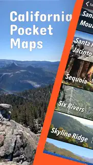
- 400+ national parks, state parks, monuments, forests
- 340+ neatly folded maps by the National Park Service, Bureau of Land Management, United States Forest Services, and other agencies.
- Motor Vehicle Use Maps (MVUM), Motor Vehicle Travel Maps (MVTM) and visitor maps for California national forests.
- 5,000+ campgrounds and campsites
- 6,200+ trails and trailheads
- 140,000+ points of interests
Plan
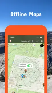
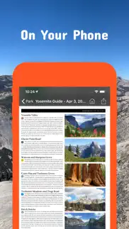
- Download maps, park brochures, and newspapers. These downloads are ready when you are offline and off the grid in the great outdoors.
- Download arbitrary map sections as offline packs.
- Photo galleries, panorama views.
- Share links to parks and maps with friends
Have fun
- GPS and GPX support: record your hikes, import GPX routes, tracks and waypoints for your hiking trails.
- Detailed national park information: alerts, news, visitor centers, campgrounds, driving directions, weather.
- Open your favorite maps app to get a route to the selected park.
- Current weather conditions, easy access to multi-day forecasts, sunrise and sunset times.
- Push notifications for park alerts, park news, weather warnings
So download maps and guides for:
Angeles
Anza-Borrego Desert
Berryessa Snow Mountain
Bizz Johnson
Cabrillo
California Costal - Point Arena - Stornetta Unit
Carrizo Plain
César E. Chávez
Channel Islands
Cleveland
Cow Mountain
Death Valley
Devils Postpile
East Bay Regional Parks
Eldorado
Fort Ord
Fort Sage
Golden Gate
Headwaters
Humboldt-Toiyabe
Inyo
Joshua Tree
Keysville
King Range
Kings Canyon
Klamath
Lake Tahoe
Lassen
Lassen Volcanic
Lava Beds
Los Padres
Mammoth Lakes
Manzanar
Mendocino
Midpeninsula Regional Open Space
Mojave
Mojave Trails
Nobles Emigrant Trail
Piedras Blancas Light Station
Pinnacles
Plumas
Point Reys
Presidio of San Francisco
Redwood
Rice Canyon
San Bernadino Mountains
San Francisco Maritime
San Gabriel Mountains
Sand to Snow
Santa Clara County Parks
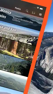
Santa Monica Mountains
Santa Rosa and San Jacinto Mountains
Sequoia
Sierra
Six Rivers
Tahoe
Whiskeytown
Yosemite
There are additional useful information and brochures for many California state parks.
- FULL ACCESS is available for a for $3.49/three month (after a free 3-days trial period) or $2.49/two months or $7.49/year. You can subscribe and pay through your iTunes account. The account will be charged for renewal within 24-hours prior to the end of the current period, and identify the cost of the renewal. Your subscription will automatically renew unless canceled at least 24 hours before the end of the current period. Auto-renew can be turned off anytime by going to your Account Settings in iTunes after purchase.
- Continued use of GPS running in the background can dramatically decrease battery life.
LEGAL
Terms of Use: https://www.icoat.de/pocketmaps/terms
Privacy Policy: https://www.icoat.de/pocketmaps/privacy
- California Pocket Maps App User Reviews
- California Pocket Maps Pros
- California Pocket Maps Cons
- Is California Pocket Maps legit?
- Should I download California Pocket Maps?
- California Pocket Maps Screenshots
- Product details of California Pocket Maps
California Pocket Maps App User Reviews
What do you think about California Pocket Maps app? Ask the appsupports.co community a question about California Pocket Maps!
Please wait! Facebook California Pocket Maps app comments loading...
California Pocket Maps Pros
The pros of the California Pocket Maps application were not found.
✓ California Pocket Maps Positive ReviewsCalifornia Pocket Maps Cons
The cons of the California Pocket Maps application were not found.
✗ California Pocket Maps Negative ReviewsIs California Pocket Maps legit?
✅ Yes. California Pocket Maps is 100% legit to us. This conclusion was arrived at by running over 96 California Pocket Maps user reviews through our NLP machine learning process to determine if users believe the app is legitimate or not. Based on this, AppSupports Legitimacy Score for California Pocket Maps is 89.5/100.
Is California Pocket Maps safe?
✅ Yes. California Pocket Maps is quiet safe to use. This is based on our NLP analysis of over 96 user reviews sourced from the IOS appstore and the appstore cumulative rating of 4.5/5. AppSupports Safety Score for California Pocket Maps is 90.0/100.
Should I download California Pocket Maps?
✅ There have been no security reports that makes California Pocket Maps a dangerous app to use on your smartphone right now.
California Pocket Maps Screenshots
Product details of California Pocket Maps
- App Name:
- California Pocket Maps
- App Version:
- 6.2
- Developer:
- Alex Gugel
- Legitimacy Score:
- 89.5/100
- Safety Score:
- 90.0/100
- Content Rating:
- 4+ Contains no objectionable material!
- Category:
- Travel, Navigation
- Language:
- EN DE
- App Size:
- 89.04 MB
- Price:
- Free
- Bundle Id:
- de.icoat.capocketmaps
- Relase Date:
- 11 October 2017, Wednesday
- Last Update:
- 27 January 2024, Saturday - 16:07
- Compatibility:
- IOS 15.0 or later
Winter 2023/2024 Updates: Arcata, East Bay Regional Parks, Midpeninsula Regional Open Space, Santa Clara County Parks, Lassen National Forest, Los Padres National Forest, Plumas National Forest Updates: Contains the latest data by the National Park ....