

- 89.0LEGITIMACY SCORE
- 89.5SAFETY SCORE
- 4+CONTENT RATING
- FreePRICE
What is Pennsylvania Pocket Maps? Description of Pennsylvania Pocket Maps 3250 chars
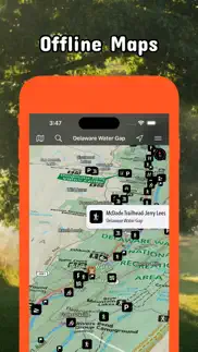
Be prepared! Plan your next trip to one of the great Pennsylvania parks. Download maps and guides before you venture into the Wi-Fi free wilderness.
Discover
- 75+ national parks, state parks, monuments, forests
- 150+ neatly folded maps by the National Park Service, Bureau of Land Management, United States Forest Services, and other agencies.
- 100+ campgrounds and campsites
- 1,600+ trails and trailheads
- 72,000+ points of interests
Plan
- Download maps, park brochures, and newspapers. These downloads are ready when you are offline and off the grid in the great outdoors.
- Download arbitrary map sections as offline packs.
- Photo galleries, panorama views.
- Share links to parks and maps with friends
Have fun
- GPS and GPX support: record your hikes, import GPX routes, tracks and waypoints for your hiking trails.
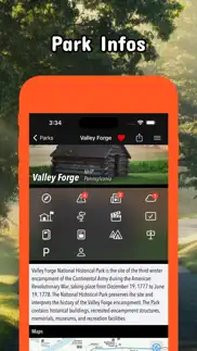
- Detailed national park information: alerts, news, visitor centers, campgrounds, driving directions, weather.
- Open your favorite maps app to get a route to the selected park.
- Current weather conditions, easy access to multi-day forecasts, sunrise and sunset times.
- Push notifications for park alerts, park news, weather warnings
So download maps and guides for:
* Allegheny, Allegheny Islands, Allegheny Portage Railroad, Appalachian, Archbald Pothole
* Bald Eagle, Beltzville, Bendigo, Benjamin Rush, Big Pocono, Big Spring, Black Moshannon, Blue Knob, Boyd Big Tree, Buchanan's Birthplace, Bucktail
* Caledonia, Canoe Creek, Captain John Smith Chesapeake, Champman, Cherry Springs, Cherry Valley, Chesapeake Bay, Chesapeake Bay Gateways and Watertrails Network, Codorus, Colonel Denning, Colton Point, Cook Forest, Cowans Gap
* Delaware & Lehigh, Delaware Canal, Delaware Water Gap, Denton Hill
* Edgar Allen Poe, Eisenhower, Elk, Erie, Erie Bluffs, Evansburg
* First State, Flight 93, Fort Necessity, Fort Washington, Fowlers Hollow, Frances Slocum, French Creek, Friendship Hill
* Gettysburg, Gifford Pinchot, Gloria Dei Church, Gouldsboro, Greenwood Furnace
* Hickory Run, Hopewell Furnace
* Independence
* John Heinz at Tinicum, Johnstown Flood, Journey Through Hallowed Ground
* Kinzua Bridge
* Laurel Hill, Laurel Ridge, Lehigh Gorge, Lower Delaware
* Moraine
* Nockamixon, North Country,
* Ohiopyle, Oil Creek, Oil Region
* Potomac Heritage, Presque Isle, Prince Gallitzin, Pymatuning
* Raccoon Creek, Ricketts Glen, Rivers of Steel
* Shawnee, Steamtown,
* Thaddeus Kosciuszko, Tobyhanna
* Upper Delaware
* Valley Forge
* Washington-Rochambeau Revolutionary Route
- FULL ACCESS is available for a for $3.49/three month (after a free 3-days trial period) or $2.49/two months or $7.49/year. You can subscribe and pay through your iTunes account. The account will be charged for renewal within 24-hours prior to the end of the current period, and identify the cost of the renewal. Your subscription will automatically renew unless canceled at least 24 hours before the end of the current period. Auto-renew can be turned off anytime by going to your Account Settings in iTunes after purchase.
- Continued use of GPS running in the background can dramatically decrease battery life.
LEGAL
Terms of Use: https://www.icoat.de/pocketmaps/terms
Privacy Policy: https://www.icoat.de/pocketmaps/privacy
- Pennsylvania Pocket Maps App User Reviews
- Pennsylvania Pocket Maps Pros
- Pennsylvania Pocket Maps Cons
- Is Pennsylvania Pocket Maps legit?
- Should I download Pennsylvania Pocket Maps?
- Pennsylvania Pocket Maps Screenshots
- Product details of Pennsylvania Pocket Maps
Pennsylvania Pocket Maps App User Reviews
What do you think about Pennsylvania Pocket Maps app? Ask the appsupports.co community a question about Pennsylvania Pocket Maps!
Please wait! Facebook Pennsylvania Pocket Maps app comments loading...
Pennsylvania Pocket Maps Pros
The pros of the Pennsylvania Pocket Maps application were not found.
✓ Pennsylvania Pocket Maps Positive ReviewsPennsylvania Pocket Maps Cons
✗ BuggyConstantly getting prompted to subscribe to view maps (every few seconds), even after purchasing a subscription. I’m requesting a refund..Version: 4.5
✗ Not itLooking for trail maps and info for all state parks and this is not it. Maybe it’s still in development but that should be stated, not lead you to believe it’s complete. It also has other state’s info which is extra data info we don’t need. There is a nice national park app already..Version: 3.2
✗ Pennsylvania Pocket Maps Negative ReviewsIs Pennsylvania Pocket Maps legit?
✅ Yes. Pennsylvania Pocket Maps is 100% legit to us. This conclusion was arrived at by running over 73 Pennsylvania Pocket Maps user reviews through our NLP machine learning process to determine if users believe the app is legitimate or not. Based on this, AppSupports Legitimacy Score for Pennsylvania Pocket Maps is 89.0/100.
Is Pennsylvania Pocket Maps safe?
✅ Yes. Pennsylvania Pocket Maps is quiet safe to use. This is based on our NLP analysis of over 73 user reviews sourced from the IOS appstore and the appstore cumulative rating of 4.5/5. AppSupports Safety Score for Pennsylvania Pocket Maps is 89.5/100.
Should I download Pennsylvania Pocket Maps?
✅ There have been no security reports that makes Pennsylvania Pocket Maps a dangerous app to use on your smartphone right now.
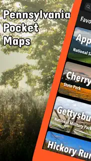
Pennsylvania Pocket Maps Screenshots

Product details of Pennsylvania Pocket Maps
- App Name:
- Pennsylvania Pocket Maps
- App Version:
- 6.3
- Developer:
- Alex Gugel
- Legitimacy Score:
- 89.0/100
- Safety Score:
- 89.5/100
- Content Rating:
- 4+ Contains no objectionable material!
- Category:
- Travel, Navigation
- Language:
- EN DE
- App Size:
- 85.43 MB
- Price:
- Free
- Bundle Id:
- de.icoat.papocketmaps
- Relase Date:
- 07 January 2020, Tuesday
- Last Update:
- 12 April 2024, Friday - 22:44
- Compatibility:
- IOS 15.0 or later
Spring 2024 Updates: Contains the latest data by the National Park Service (NPS), Bureau of Land Management (BLM), United States Forest Service (USFS) and recreation.gov..