
- 78.1LEGITIMACY SCORE
- 82.1SAFETY SCORE
- 4+CONTENT RATING
- FreePRICE
What is SeaNav? Description of SeaNav 3999 chars
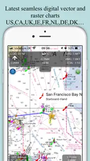
Explore, plan and navigate your boating trips in real time and outstanding high-resolution using digital charts derived from the latest NOAA and UKHO data providing coverage across the US and Europe (US, CA, UK & IE, DE, FR, NL, BE, DK, NO,ES,HR,PT). Raster charts for US, NZ, FI & EE.
- Vector charts - all buoys, lights etc. are tappable
- Seamless fast panning and zoom across charts
- Route Planning and real-time tracking
- North up and course up displays
- Offline charts
- Configurable layers
- Built-in tutorial mode with full features including charts, AIS, AR & wind
- Tides, Streams & Weather
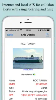
- Live AIS Ship positions and collision alarm (IAP)
- Import and share routes and POIs in GPX and KML formats via email and Dropbox
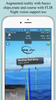
- Live Augmented Reality camera view (IAP) plus FLIRONE® night vision support.
- Includes free Apple Watch app with Nav,Waypoint,Wind,AIS faces.
- NMEA Depth, Wind Speed and Direction
- Real time local wind feed (IAP)
The free version includes all navigation and trip planning tools. High resolution vector charts are available by In App Purchase (IAP) including updates for 12 months.
Vector charts provide many advantages over traditional raster charts. Buoys, Lights, Bridges, Depth Contours, Depth Soundings, Rocks, Anchorage areas, NOAA Weather Buoys etc. are all selectable and have real time distance, bearing and detail information. Turn off layers to de-clutter the display and only show what is important at the time. Tides, moon and sun times and weather are also all available at your fingertips.
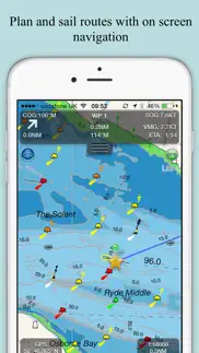
In-app tools let you measure distances and bearings and record waypoints on routes to sail. When you are out at sea, the app’s Sailing HUD shows your position on the route, Course over ground (COG), Speed over ground (SOG), Vector Made Good (VMG), Estimated Time of Arrival (ETA), Distance and bearing to next Waypoint. Waypoint reached alerts, auto-routing to the next waypoint and flashing collision alerts (with AIS).
Unique AR view mode (IAP) allows you to view buoys, lights, ships, waypoints, route and track overlaid on your iPhone or iPad live camera view. With "AR LockOn" you can select a target on the chart and then be guided to it in the AR camera view. You can also see at night and in the fog with the FLIRONE Infra-red camera.
External NMEA GPS, AIS and Wind data over Wifi.
Requirements:
GPS only required for real time route navigation. Optional Real time AIS, Tides and Weather information require an active internet connection.
WiFi-only iPad or iPods will need an external GPS receiver for navigation.
Please note that continued use of GPS running in the background can dramatically decrease battery life.
Subscriptions
Our in-app purchases are 1 year subscriptions, which automatically renew at the end of the subscription period unless auto-renew is turned off at least 24-hours before the end of the current period. Payment will be charged to your iTunes Account at confirmation of purchase, and will be charged for renewal within 24-hours prior to the end of the current period. Pricing for our 1 year US Charts update subscription is $19.99.
Subscriptions may be managed by the iTunes account holder and auto-renewal may be turned off by going to Account Settings after purchase.
No cancellation of the current subscription is allowed during active subscription period.
NOTICES: This product has been derived in part from material obtained from the UK Hydrographic Office with the permission of the UK Hydrographic Office, Her Majesty’s Stationery Office.” “© British Crown Copyright, [2012]. All rights reserved.
The UK Hydrographic Office (UKHO) and its licensors make no warranties or representations, express or implied, with respect to this product. The UKHO and its licensors have not verified the information within this product or quality assured it.
Terms of Use: http://seanav.net/termsofuse.php
Privacy Policy: http://seanav.net/privacy.php
Support: [email protected]
- SeaNav App User Reviews
- SeaNav Pros
- SeaNav Cons
- Is SeaNav legit?
- Should I download SeaNav?
- SeaNav Screenshots
- Product details of SeaNav
SeaNav App User Reviews
What do you think about SeaNav app? Ask the appsupports.co community a question about SeaNav!
Please wait! Facebook SeaNav app comments loading...
SeaNav Pros
✓ Excellent nav toolBest app for marine navigation bar none! In-app purchases are also well priced and actually increase functionality and usefulness. Must buy for boaters, especially big water..Version: 3.8.2
✓ Intuitive and accurateI have had SeaNav for a year now and have learned to trust it. It is just as accurate as any high dollar system and is easy to use..Version: 5.2
✓ SeaNav Positive ReviewsSeaNav Cons
✗ Not worth it!!I’d suggest switching to android and making a one time fee of $15 for MX Mariner. Although this app offers some great instruments and charts I don’t believe it’s worth all the money. In the US you’re looking at $20 a year just for the charts and that doesn’t include another $10 for the Raster charts plus another $10 for AIS instrument. It just keeps adding up. If you’re actually using it to Navigate the waterways good luck cause you can’t even zoom in enough to see if you’re inside of the channels. The person who designed this isn’t thinking about the Mariners they’re in it for the money! Just saying, don’t waste your time and money on this one better off downloading a free one for IOS..Version: 5.3.5
✗ NOAA CHARTS ARE FREE TO THE PUBLICAny app that makes you pay for them is ripping you off….Version: 5.3.5
✗ SeaNav Negative ReviewsIs SeaNav legit?
✅ Yes. SeaNav is legit, but not 100% legit to us. This conclusion was arrived at by running over 270 SeaNav user reviews through our NLP machine learning process to determine if users believe the app is legitimate or not. Based on this, AppSupports Legitimacy Score for SeaNav is 78.1/100.
Is SeaNav safe?
✅ Yes. SeaNav is quiet safe to use. This is based on our NLP analysis of over 270 user reviews sourced from the IOS appstore and the appstore cumulative rating of 4.3/5. AppSupports Safety Score for SeaNav is 82.1/100.
Should I download SeaNav?
✅ There have been no security reports that makes SeaNav a dangerous app to use on your smartphone right now.
SeaNav Screenshots
Product details of SeaNav
- App Name:
- SeaNav
- App Version:
- 5.4.5
- Developer:
- Pocket Mariner Ltd.
- Legitimacy Score:
- 78.1/100
- Safety Score:
- 82.1/100
- Content Rating:
- 4+ Contains no objectionable material!
- Category:
- Navigation, Travel
- Language:
- DA EN FR DE ES
- App Size:
- 69.30 MB
- Price:
- Free
- Bundle Id:
- com.electricpocket.seanav.zz
- Relase Date:
- 24 April 2014, Thursday
- Last Update:
- 19 October 2023, Thursday - 08:44
- Compatibility:
- IOS 11.0 or later
Charts for the whole of France and Portugal now available Fix for start up problems on iOS 17 when trying to load the charts..