
- 85.3LEGITIMACY SCORE
- 89.8SAFETY SCORE
- 4+CONTENT RATING
- FreePRICE
What is Aqua Map Boating? Description of Aqua Map Boating 4064 chars
Start Your 14-Day Free Trial on All Subscriptions Today
Get the latest charts you can use offline, weather, tides and POIs from ActiveCaptain and Waterway Guide.
Connect AIS and your boat GPS and instruments data via WiFi connection. Plan routes, record your tracks, find new friends on the water and share your data across the Live Sharing community.
THE MOST ADVANCED MARINE NAVIGATION APP
• Optimised for both iPhone and iPad with multi-screen mode
• Vector and raster nautical charts for offline use, updated regularly
• Satellite image
• Routes/Tracks navigation with real-time information on bridges, hazards, and best fuel prices
• Manual route planning
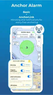
• Basic anchor alarm and AnchorLink with mirroring and email/telegram notifications
• Marine Forecasts for wind, waves, currents and worldwide weather information
• 1800+ Weather buoys to get real time sea info
• Tide & Current predictions and simulations
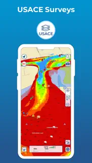
• USACE surveys and USCG List of lights
• 14000+ vector lake maps
• Easy sharing and uploading of tracks, markers and routes
• Live Sharing-Aqua Map community to find new friends on the water
• ActiveCaptain & Waterway Guide community integration
• Real time display of NMEA instruments (depth sounder, wind sensor, compass, GPS)
• AIS target display with automatic collision detection
• Powerful search with advanced settings
• Light/Dark display
• Optimised battery usage
► NAUTICAL CHARTS
Official NOAA charts complete with depth contours, navigation markers, buoys, lights and other chart features. You can download the maps at home on all your devices and use them on the boat offline (no internet connection required).
► ROUTES and WAYPOINTS
Plan your trip, insert and edit waypoints. Navigate your route and your track, monitor distance, time (ETA), course and heading to next waypoint or your final destination.
► ANCHOR ALARM
Set the anchor position and drift radius and monitor in real time. If the GPS position is outside the defined range, an acoustic alarm is sounded and a visual alarm is displayed. Low battery and bad GPS reception alarms are also available.
► TIDES & CURRENTS
You can calculate the prediction for more than 7500 stations in US, Canada, Bahamas & Australia. See the T&C trend on the map and simulate any future date.
► LOADING and SHARING
You can share your favorite's markers on Facebook or send an email with your last daily track. Not only, you can also load any KML, KMZ, GPX found in internet or received from your friends.
► COMMUNITIES
Join “Live Sharing” and become part of Aqua Map community: find new friend on the water, chat and send your data to anyone without leaving the app.
Access tens of thousands of points of interests and reviews all over the world from ActiveCaptain and Waterway Guide communities.
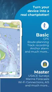
► AQUA MAP MASTER
Transform your device into a chartplotter:
• Most updated USACE surveys and USCG List of Lights
• Marine forecasts (wind, waves, currents and weather)
• AnchorLink with mirroring and telegram/email notifications
• Connect NMEA (and SignalK) devices through WiFi and use instrument and AIS data all across the app (navigation and anchor alarm)
• Display AIS targets on the chart with automatic collision detection
• Route Explorer with real-time information on bridges, hazards, and best fuel prices
(Note: This subscription includes extra features but does not include cartography; it must therefore be paired with a cartography subscription)
► TYPE OF PURCHASES
Unlimited: download and update forever (available only for some subscription)
Subscription: one year auto-renewable subscription. The payment will be made through your (Apple ID) account. The subscription will renew automatically unless cancelled at least 24 hours before the expiration. The user can manage their subscription and turn off auto-renewal in the Apple ID Account Settings section after purchase.
Terms of Service: https://www.aquamap.app/terms-and-conditions
Privacy Policy: https://www.aquamap.app/privacy-policy
- Aqua Map Boating App User Reviews
- Aqua Map Boating Pros
- Aqua Map Boating Cons
- Is Aqua Map Boating legit?
- Should I download Aqua Map Boating?
- Aqua Map Boating Screenshots
- Product details of Aqua Map Boating
Aqua Map Boating App User Reviews
What do you think about Aqua Map Boating app? Ask the appsupports.co community a question about Aqua Map Boating!
Please wait! Facebook Aqua Map Boating app comments loading...
Aqua Map Boating Pros
✓ The best!I use iNavX and Aqua Map. One uses raster charts and the other uses vector charts. They are the best of the best (I also have a Garmin dedicated chartplotter). Of the two, Aqua Maps is easier to use, gives more information (especially with the USACE overlays and the Active Captain data), and is less expensive to load up with charts that cover the whole US and Canada. Update: After several more years and a few thousand more miles, AquaMap is still my favorite..Version: 27.2
✓ Easy & AccurateWe’ve been using Aquamaps for three years. It’s my go to for finding anchorages and marinas. I like that it has Waterway Guide and Active Captain within the same app. It’s easy to use and has tutorials to assist with becoming a pro. The added weather with wind and waves is a true time saver!.Version: 31.2
✓ Aqua Map Boating Positive ReviewsAqua Map Boating Cons
✗ Disappearing charts, but great featuresThis app has become my go to after losing Garmin BlueChart. The features are great with the along route info on bridges, fuel stops etc and the USACE sonar survey overlay is an amazing tool! BUT, despite ensuring the button in settings is off for delete charts in case of low available space my charts continue to disappear from two devices, but more obvious on my phone than tablet. Wrote to tech support and was dismissed as the button being my issue. It is certainly not on and I continue to have my charts disappear or require downloading 4-5 times before the tiles stop showing update in the corner. This app is on track to be great, but is currently unreliable..Version: 14.1
✗ Not impressed so farEdit to previous review: After I figured out that my cell signal just wasn’t good enough (worked for everything else?) I was able to get the maps I wanted to upload after moving to a different spot. The next day I did receive a response via email from customer service. Can’t really vouch for using the app yet. Raised from 1 star Previous 1st time review: I decided to pay for an upgrade to try it out and maps won’t download in areas I paid for. Sits there saying it’s downloading, then after having to wait for it to do so, it places a pop-up saying some maps didn’t download properly check storage, no other option. Check storage and there’s almost 200 GB available. Are the maps really that large?.Version: 36.2
✗ Aqua Map Boating Negative ReviewsIs Aqua Map Boating legit?
✅ Yes. Aqua Map Boating is 100% legit to us. This conclusion was arrived at by running over 9,749 Aqua Map Boating user reviews through our NLP machine learning process to determine if users believe the app is legitimate or not. Based on this, AppSupports Legitimacy Score for Aqua Map Boating is 85.3/100.
Is Aqua Map Boating safe?
✅ Yes. Aqua Map Boating is quiet safe to use. This is based on our NLP analysis of over 9,749 user reviews sourced from the IOS appstore and the appstore cumulative rating of 4.7/5. AppSupports Safety Score for Aqua Map Boating is 89.8/100.
Should I download Aqua Map Boating?
✅ There have been no security reports that makes Aqua Map Boating a dangerous app to use on your smartphone right now.
Aqua Map Boating Screenshots

Product details of Aqua Map Boating
- App Name:
- Aqua Map Boating
- App Version:
- 37.8
- Developer:
- GEC S.r.l.
- Legitimacy Score:
- 85.3/100
- Safety Score:
- 89.8/100
- Content Rating:
- 4+ Contains no objectionable material!
- Category:
- Navigation, Travel
- Language:
- NL EN FR DE IT PT ES
- App Size:
- 135.52 MB
- Price:
- Free
- Bundle Id:
- gec.MarineApp.WorldViewerLiteHD
- Relase Date:
- 15 October 2014, Wednesday
- Last Update:
- 10 April 2024, Wednesday - 07:40
- Compatibility:
- IOS 12.0 or later
+ Small improvements to always have the most reliable application.