
- 99.0LEGITIMACY SCORE
- 99.5SAFETY SCORE
- 4+CONTENT RATING
- $34.99PRICE
What is I-Boating:Sweden Marine Charts? Description of I-Boating:Sweden Marine Charts 4108 chars
This App offers offline nautical charts,lake & river navigation maps covering Sweden/Sverige for fishing,kayaking,boating & sailing. Coverage includes marine vector charts,freshwater lake maps & inland river maps. First marine GPS app to have route assistance with Voice Prompts for marine navigation. You can create new boating routes or import existing GPX/KML routes. It supports Nautical Charts course up orientation. Includes Tide & Currents prediction.
►FEATURES
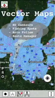
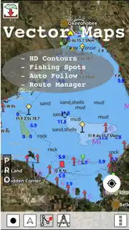
√ Beautiful & detailed Hardware/GPU accelerated vector charts (text stays upright on rotation)
√ Query details of Marine object (Buoy,Lights,Obstruction etc).
√ Customizable depth(Ft/Fathom/Meter) & distance units (km/mi/NM)
√ Customizable Shallow Depth.
√ Record tracks,Autofollow with real-time track overlay & predicted path vector.
√ Voice Prompts for marine navigation (requires GPS )
√ Supports GPX/KML for boating route editing/import.
√ Tide & Currents prediction.
√ Seamless chart quilting. Map details from Coastal,Approaches,Harbour,Inland
Encs(rivers)& general ENC charts are automatically mapped to correct zoomlevel
√ Enter or import Waypoints.
► MAPS
Get all the details that you find in your chart plotters!
Includes unlimited updates for 1 year.
Sweden
►ROUTE MANAGEMENT / TRIP PLANNING
√ Create New Route/Edit Routes
√ Reverse Routes
√ Enter,Move,Add,Delete,Rename Waypoints
√ Import GPX,KML & KMZ files
√ Plot/Edit Routes
√ Share/Export Routes,Tracks & Markers
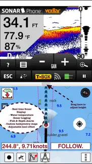
►GPS FEATURES
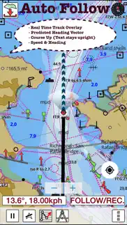
√ Auto Follow
* Real Time Track Overlay
* Predicted Path Vector
* Course Up (Text stays upright)
* Speed & Heading
√ Route Assistance With Voice Prompts
* Prompts when approaching a boating route marker
* Continous distance & ETA updates
* Alerts when sailing/boating off route
* Alerts when boating in wrong direction
√ Record Tracks
►TIDE & CURRENTS
* For US,Canada,UK,Germany&New Zealand
* High/Low Tides
* Tidal Current Prediction
* Active Current Stations
► SHARING
* Share tracks/routes/markers on Facebook & Twitter
* Export as compressed GPX files.
Sample Charts
Almagrundet
Argos grund
Arholma
Arild
Arkö
Arkö
Askö
Asplången
Aspöja
Baltic Sea
Bay of Bothnia
Berg
Bergkvara
Blackan
Blidö
Bockholmssundet
Bokösund
Bollsta
Borgholm
Brandalsund
Brofjorden
Bråviken
Bullerön
Byxelkrok
Bålsön
Båstad
Böda
Dalbosjön
Dalslands Kanal
Degerhamn
Djursö
Djurö
Dämman
Edsviken
Eggegrund
Ekenäs
Enköping
Enköpingsån
Erikssund
Falkenberg
Fladen
Flaten
Flintrännan
Fläskösund
Forsmark
Freden
Fredlarna
Furusund
Fyrudden
Färingsö
Fångö
Fårösund
Galten
Gamleby
Glommen
Gotland
Gotska Sandön
Granön
Grinda
Gränna
Gränsö
Grässkären
Gräsö
Gräsö ost
Grönskär
Gullmarn
Gunnebo
Gustaf Dalén
Gustavsberg
Gällfjärden
Gällnö
Gävle
Gålön
Göta älv
Göteborg
Hallstavik
Halmstad
Hamburg/Havsstenssund
Hanö
Haparanda
Hargshamn
Hartsön
Helsingborg
Hjälmare kanal
Hjälmaren
Holmsund
Holmön
Hornslandet
Horsfjärden
Hudiksvall
Husum
Huvudskär
Hällgrund
Härnösand
Härsö
Hätteberget
Hävringe
Höganäs
Högmarsö
Hönsäter
Hörnefors
Hörvik
Idefjorden
Idö
Ingmarsö
Inland
Jungfrufjärden
Järflotta
Järnäs
Jättersön
Jönköping
Kagghamra
Kalmar
Kalvfjärden
Kapellskär
Karlsborg
Karlshamn
Stilleryd
Karlskrona
Karlstad
Kaskären
Kattegatt
Kivik
Koster
Kosterfjorden
Kristanopel
Kristinehamn
Kullen
Kungsgrundet
Kusön
Kvicksund
Kvädö
Kymmendö
Kyrkesund
Kållandsö
Kårehamn
Köping
L Milskär
Lacka
Landskrona
Landsort
Landsortsdjupet
Lidingö
Lilla Middelgrund
Lillhammarsgrund
Loftahammar
Luleå
Lysekil
Låglandsbåden
Långskär
Malmö
Malören
Mariestad
Marstrand
Mellerud
Mem
Midlanda
Motala
Mälaren
Mällsten
Märketskallen
Måseskär
Möja
Mölle
Mönsterås
Mörkö
Nogersund
Nordmaling
Nordre älv
Finnö
Fällbådan
Kränkan
Norra Ljusterö
Norrfjärden
Norrköping
Norrsundet
Norrtälje
Nykvarn
Nyland
Nynäshamn
Nämdö
Nåttarö
Odelgrund
Oland
Oregrund
Oresund
Ormingelandet
Ornö
Oskarshamn
Otterbäcken
Battery disclamier:
“Continued use of GPS running in the background can dramatically decrease battery life.”
- I-Boating:Sweden Marine Charts App User Reviews
- I-Boating:Sweden Marine Charts Pros
- I-Boating:Sweden Marine Charts Cons
- Is I-Boating:Sweden Marine Charts legit?
- Should I download I-Boating:Sweden Marine Charts?
- I-Boating:Sweden Marine Charts Screenshots
- Product details of I-Boating:Sweden Marine Charts
I-Boating:Sweden Marine Charts App User Reviews
What do you think about I-Boating:Sweden Marine Charts app? Ask the appsupports.co community a question about I-Boating:Sweden Marine Charts!
Please wait! Facebook I-Boating:Sweden Marine Charts app comments loading...
I-Boating:Sweden Marine Charts Pros
The pros of the I-Boating:Sweden Marine Charts application were not found.
✓ I-Boating:Sweden Marine Charts Positive ReviewsI-Boating:Sweden Marine Charts Cons
The cons of the I-Boating:Sweden Marine Charts application were not found.
✗ I-Boating:Sweden Marine Charts Negative ReviewsIs I-Boating:Sweden Marine Charts legit?
✅ Yes. I-Boating:Sweden Marine Charts is 100% legit to us. This conclusion was arrived at by running over 11 I-Boating:Sweden Marine Charts user reviews through our NLP machine learning process to determine if users believe the app is legitimate or not. Based on this, AppSupports Legitimacy Score for I-Boating:Sweden Marine Charts is 99.0/100.
Is I-Boating:Sweden Marine Charts safe?
✅ Yes. I-Boating:Sweden Marine Charts is quiet safe to use. This is based on our NLP analysis of over 11 user reviews sourced from the IOS appstore and the appstore cumulative rating of 5/5. AppSupports Safety Score for I-Boating:Sweden Marine Charts is 99.5/100.
Should I download I-Boating:Sweden Marine Charts?
✅ There have been no security reports that makes I-Boating:Sweden Marine Charts a dangerous app to use on your smartphone right now.
I-Boating:Sweden Marine Charts Screenshots
Product details of I-Boating:Sweden Marine Charts
- App Name:
- I-Boating:Sweden Marine Charts
- App Version:
- 127.0.0
- Developer:
- Bist LLC
- Legitimacy Score:
- 99.0/100
- Safety Score:
- 99.5/100
- Content Rating:
- 4+ Contains no objectionable material!
- Category:
- Navigation, Travel
- Language:
- NL EN FI FR DE NB RU SV
- App Size:
- 63.36 MB
- Price:
- $34.99
- Bundle Id:
- com.skiracer.semarinevec
- Relase Date:
- 11 March 2016, Friday
- Last Update:
- 03 November 2022, Thursday - 09:32
- Compatibility:
- IOS 8.0 or later
- Auto Routing - Marine Weather Forecasts - Compiled with latest version of Xcode.