
- 81.3LEGITIMACY SCORE
- 83.8SAFETY SCORE
- 4+CONTENT RATING
- $22.99PRICE
What is Marine Navigation - Lake Depth Maps - USA - Offline Gps Nautical Charts for Fishing, Sailing and Boating? Description of Marine Navigation - Lake Depth Maps - USA - Offline Gps Nautical Charts for Fishing, Sailing and Boating 3641 chars
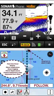
Marine Navigation App offers access to NOAA marine vector charts, freshwater lake maps, USACE inland river maps. Only marine GPS app to have route assistance with Voice Prompts for marine navigation. It has route manager to create new boating routes or import existing GPX/KML routes. It supports Nautical Charts course up orientation. Includes Tide & Currents prediction.
* Hardware/GPU accelarated vector charts (text stays upright on rotation).
* Voice Prompts for marine navigation (requires GPS )
* 1ft / 3ft depth contour maps for anglers for selected lake maps.
* Supports GPX/KML for boating route editing/import.
* Tide & Currents prediction.
* Seamless chart quilting of marine charts
* Enter way points
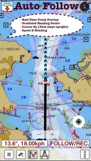
* Record tracks, Autofollow with realtime track overlay
* Voice Prompts for marine navigation (requires GPS )
-prompts when approaching a boating route marker
-Continous distance and ETA updates
-Alerts when sailing/boating off route
-Alerts when boating in wrong direction
*Route Editing/Creation
-Create routes from scratch
-Edit existing GPX/KML routes.
-Add custom description to any route point.
-Drop markers along route.
* Offline NOAA marine, lake & river charts
-Visually download using grid
-Textual search
* Tide & Currents
- High / Low tides.
- Tidal Currents.
- Active currents stations.
*Seamless chart quilting of marine charts
*Distance Bearing tool
*Create custom way points
- Using GPS
-Select point on map
-Manually enter latitude & longitude coordinates
*Pan/Zoom/My Location
* Record Marine GPS tracks
* View tracks overlay
* Live track animation
* Track analytics/stats
* Export GPX trcks.
-Export to SDCard
-Share GPX tracks with friends.
* Auto Follow Mode (Course up)
-Continuously updates boat's location on chart
- Adjustable update frequency
Sample Nautical Charts (please visit http://gpsnauticalcharts.com/main/folio-catalog-nautical-charts-app for complete list)
SUGARLOAF KEY-KEY WEST
PORT RICHEY TAMPA BAY - CLEARWATER HBR
EAST BAY-WEST BAY FLORIDA
ST JOSEPH, ST ANDREW BAYS
INTRACOASTAL WATERWAY MATECUMBE-GRASSY KEY
CHESAPEAKE BAY CAPE CHARLES-NORFOLK HARBOR
ANCLOTE KEYS-CRYSTAL RIVER
ST JOSEPH SOUND
MIAMI HARBOR
Minnesota lakes - Kabetogama, Minnetonka, Waconia,Leech,Mille Lacs
Lake Keowee,Jocassee,Hartwell,Greenwood,Lake Murray
Mark Twain,Ozarks,Table Rock
Lake St. Clair
Lake Kentucky
KEY WEST-THE MISSISSIPPI RIVER
SAN PEDRO CHANNEL
LAKE MICHIGAN STONY LAKE-POINT BETSIE
APALACHICOLA BAY-CAPE SAN BLAS
EAST CAPE-MORMON KEY
CAPE HENLOPEN-INDIAN RIVER INLET
CHESAPEAKE BAY CAPE HENRY-THIMBLE SHOAL LIGHT
DULUTH-SUPERIOR HARBOR
MONHEGAN ISLAND-CAPE ELIZABETH
LAKE ONTARIO - CLAYTON-FALSE DUCKS ISL
Lake Winnipesaukee
SAN FRANCISCO ENTRANCE
MIAMI-MARATHON, FLORIDA BAY
CAPE MAY-FENWICK ISLAND
MISSISSIPPI RIVER-GALVESTON
CAPE CANAVERAL-KEY WEST
DELAWARE RIVER WILMINGTON-PHILADELPHIA
FLORIDA KEYS SOMBRERO KEY-SAND KEY
SAN PABLO BAY
RAINY LAKE BIG ISLAND MINN-OAKPOINT ISL ONT
INTRACOASTAL WATERWAY - BISCAYNE BAY
EVERGLADES NTL PARK - SHARK RVR-LOSTMANS RVR
MIAMI-MARATHON & FLORIDA BAY
BLACKBURN BAY
LAKE HURON
LAKE TAHOE
STRAITS OF MACKINAC
NORFOLK HARBOR & ELIZABETH RIVER
SAN DIEGO-SANTA ROSA ISLAND
DELAWARE BAY
CHOPTANK RIVER CAMBRIDGE-GREENSBORO
FORT LAUDERDALE PORT EVERGLADES
ST SIMONS SOUND-TOLOMATO RIVER
CHESAPEAKE DELAWARE CANAL
CAPE MENDOCINO
STRAIT OF JUAN DE FUCA ENTRANCE
PORT RICHEY CLEARWATER HBR
PAMPANO BEACH-HALLADALE FLORIDA
LAKE ERIE
LAKE MICHIGAN INCLUDING GREEN BAY
MAIMI-MARATHON and FLORIDA BAY
SANTA CATALINA ISLAND
APALACHICOLA BAY-LAKE WIMICO
Battery Disclaimer:
"Continued use of GPS running in the background can dramatically decrease battery life."
- Marine Navigation - Lake Depth Maps - USA - Offline Gps Nautical Charts for Fishing, Sailing and Boating App User Reviews
- Marine Navigation - Lake Depth Maps - USA - Offline Gps Nautical Charts for Fishing, Sailing and Boating Pros
- Marine Navigation - Lake Depth Maps - USA - Offline Gps Nautical Charts for Fishing, Sailing and Boating Cons
- Is Marine Navigation - Lake Depth Maps - USA - Offline Gps Nautical Charts for Fishing, Sailing and Boating legit?
- Should I download Marine Navigation - Lake Depth Maps - USA - Offline Gps Nautical Charts for Fishing, Sailing and Boating?
- Marine Navigation - Lake Depth Maps - USA - Offline Gps Nautical Charts for Fishing, Sailing and Boating Screenshots
- Product details of Marine Navigation - Lake Depth Maps - USA - Offline Gps Nautical Charts for Fishing, Sailing and Boating
Marine Navigation - Lake Depth Maps - USA - Offline Gps Nautical Charts for Fishing, Sailing and Boating App User Reviews
What do you think about Marine Navigation - Lake Depth Maps - USA - Offline Gps Nautical Charts for Fishing, Sailing and Boating app? Ask the appsupports.co community a question about Marine Navigation - Lake Depth Maps - USA - Offline Gps Nautical Charts for Fishing, Sailing and Boating!
Please wait! Facebook Marine Navigation - Lake Depth Maps - USA - Offline Gps Nautical Charts for Fishing, Sailing and Boating app comments loading...
Marine Navigation - Lake Depth Maps - USA - Offline Gps Nautical Charts for Fishing, Sailing and Boating Pros
✓ Like the updatesI had this app on my Sony Xperia before I got an iPhone. Setting up on iPhone was a lot easier since I didn't have to plot routes again. I was able to transfer all my routes from Xperia to this one. They are very responsive to feedback. I had asked them to add lake Sammamish over a month back. And today I was able to get a bathy chart for this lake and I can see they have added almost every popular lake around my area. I am very pleased with this level of app support..Version: 14.0.0
✓ Nice navigation toolsI have been trying the nav tools all this morning. Very impressed with how accurate the next point alerts are. It even correctly alerted me for wrong course during my testing. Thanks for listening and adding support for real time track overlay in this update. It makes it very easy to follow what path I have taken..Version: 14.0.0
✓ Marine Navigation - Lake Depth Maps - USA - Offline Gps Nautical Charts for Fishing, Sailing and Boating Positive ReviewsMarine Navigation - Lake Depth Maps - USA - Offline Gps Nautical Charts for Fishing, Sailing and Boating Cons
✗ Decent appI got the impression from the app description that you could see a map that simultaneously provides all of the data that's provided by the app -- location, depth, current tide and tide forecast. Unfortunately, it's not the case. However, it does have the info you need -- it just takes a little bit of navigating through the app and head-math to get to it..Version: 22.0.0
✗ Don'tI just wasted 15 bucks on this! No key to map symbols and no response from support. Map quality lacking..Version: 22.0.0
✗ Marine Navigation - Lake Depth Maps - USA - Offline Gps Nautical Charts for Fishing, Sailing and Boating Negative ReviewsIs Marine Navigation - Lake Depth Maps - USA - Offline Gps Nautical Charts for Fishing, Sailing and Boating legit?
✅ Yes. Marine Navigation - Lake Depth Maps - USA - Offline Gps Nautical Charts for Fishing, Sailing and Boating is 100% legit to us. This conclusion was arrived at by running over 75 Marine Navigation - Lake Depth Maps - USA - Offline Gps Nautical Charts for Fishing, Sailing and Boating user reviews through our NLP machine learning process to determine if users believe the app is legitimate or not. Based on this, AppSupports Legitimacy Score for Marine Navigation - Lake Depth Maps - USA - Offline Gps Nautical Charts for Fishing, Sailing and Boating is 81.3/100.
Is Marine Navigation - Lake Depth Maps - USA - Offline Gps Nautical Charts for Fishing, Sailing and Boating safe?
✅ Yes. Marine Navigation - Lake Depth Maps - USA - Offline Gps Nautical Charts for Fishing, Sailing and Boating is quiet safe to use. This is based on our NLP analysis of over 75 user reviews sourced from the IOS appstore and the appstore cumulative rating of 4.3/5. AppSupports Safety Score for Marine Navigation - Lake Depth Maps - USA - Offline Gps Nautical Charts for Fishing, Sailing and Boating is 83.8/100.
Should I download Marine Navigation - Lake Depth Maps - USA - Offline Gps Nautical Charts for Fishing, Sailing and Boating?
✅ There have been no security reports that makes Marine Navigation - Lake Depth Maps - USA - Offline Gps Nautical Charts for Fishing, Sailing and Boating a dangerous app to use on your smartphone right now.
Marine Navigation - Lake Depth Maps - USA - Offline Gps Nautical Charts for Fishing, Sailing and Boating Screenshots


Product details of Marine Navigation - Lake Depth Maps - USA - Offline Gps Nautical Charts for Fishing, Sailing and Boating
- App Name:
- Marine Navigation - Lake Depth Maps - USA - Offline Gps Nautical Charts for Fishing, Sailing and Boating
- App Version:
- 58.0.0
- Developer:
- Bist LLC
- Legitimacy Score:
- 81.3/100
- Safety Score:
- 83.8/100
- Content Rating:
- 4+ Contains no objectionable material!
- Category:
- Navigation, Travel
- Language:
- NL EN FI FR DE NB
- App Size:
- 48.63 MB
- Price:
- $22.99
- Bundle Id:
- com.skiracer.usmarine
- Relase Date:
- 12 February 2013, Tuesday
- Last Update:
- 17 February 2016, Wednesday - 22:16
- Compatibility:
- IOS 7.0 or later
This app has been updated by Apple to display the Apple Watch app icon. -Support for Object Query, Vexilar.