
- 39.9LEGITIMACY SCORE
- 41.4SAFETY SCORE
- 4+CONTENT RATING
- $14.99PRICE
What is Great Lakes HD Nautical Charts? Description of Great Lakes HD Nautical Charts 3143 chars
Flytomap is a valid and interesting alternative, Benetti Yachts
Top Ten since 2008
Featured in : On the Deck
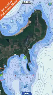
Great Lakes - The whole coverage resident in the app. It works WITHOUT mobile coverage!
• Worldwide Marine,Lakes and Outdoor Maps available, thanks to viewer.flytomap.com
• Worldwide Satellite images overlay on charts
• Worldwide Terrain features overlay on charts, thanks to Open Street Map, Open Cycle Map, Bing,Earth,Topo Chart and GMap
• Local Weather forecast
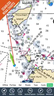
Now with NOAA,USGS,DRG,Topo raster charts seamless with continuous updates from the official Government server
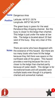
Now with ActiveCaptain - Worldwide boaters and fishermen community, with * 200.000 + Captains
Use to Explore:
√ Latitudes and Longitudes to go to your favorite places
√ Search your Favorite points directly
√ Zoom, Rotate and Pan fast just by a finger touch
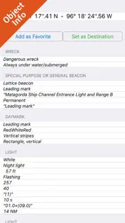
√ Quick Object information just tapping, thanks to vector technology
√ GPS Heading Vector Towards the direction movement
√ Distance Measurement Tool to easily calculate the distance from one location to another
√ Route planning, Waypoints - Insert the target/destination and see in real time your speed, distance and bearing
√ Magnified Lens for all info
√ Unlimited Tracks, Markers, Fishing Spots, Geo-tagged photos, records and share via email, visible on Google, Flytomap Viewer, KMZ format - Store your track without the need of cellular data or mobile signal
√ Select Depth Contours
√ a la carte menu
√ MOB - Man Over Board
√ Quick WP - allows you to instantly record your position and show distance and bearing
√ iOS background mode - Flytomap works in background as well, you can swap with another app and receive/make calls send sms while track recording.
√ Optimized battery usage
√ ActiveCaptain
• View and contribute to the best boaters community available in the world
• Continuous update of all info (including reviews from the deck) about :
• Marinas
• Anchorages
• Hazards
• Local Knowledge
√ Local Marine Weather forecast at a quick tap provide you:
• Day max and min temperature - Current temperature
• Significant wave height, Swell height, Swell period, Swell direction
• Tide data
• Sea temperature
• Wind Speed and direction
• Weather description
• Precipitation & Humidity
• Visibility
• Pressure
• Cloud cover in percentage
• Wind chill/Feels like Temperature
• Water Temperature
• Dew Point Temperature
• Heat Index Temperature
√ And so much more to come - It’s the only app you will ever need! Our charts are installed on: GARMIN NAVICO LOWRANCE B&G NORTHSTAR EAGLE SIMRAD
Follow us:
▶Twitter @flytomap
▶Web Site flytomap.com
▶Web App viewer.flytomap.com
▶Facebook facebook.com/flytomap
Flytomap is committed to constant improvement, this App is developed with the help of professional boaters to get the best experience on the sea, we listen to our users and systematically add the most requested features.
Thank you for the feedback!
"Continued use of GPS running in the background can dramatically decrease battery life."
- Great Lakes HD Nautical Charts App User Reviews
- Great Lakes HD Nautical Charts Pros
- Great Lakes HD Nautical Charts Cons
- Is Great Lakes HD Nautical Charts legit?
- Should I download Great Lakes HD Nautical Charts?
- Great Lakes HD Nautical Charts Screenshots
- Product details of Great Lakes HD Nautical Charts
Great Lakes HD Nautical Charts App User Reviews
What do you think about Great Lakes HD Nautical Charts app? Ask the appsupports.co community a question about Great Lakes HD Nautical Charts!
Please wait! Facebook Great Lakes HD Nautical Charts app comments loading...
Great Lakes HD Nautical Charts Pros
✓ Great app at a good priceI ended up giving this app a more thorough testing than I'd planned a few weeks ago - I bought a sailboat in the USA and sailed it back to the Toronto area across Lake Ontario. I'd forgotten my gps chart plotter at home and my new iPad (with the cell chip) was my only nav instrument aside from my compass. I turned on the tracking feature and headed off. Every tack and turn was faithfully recorded, and I steered a nice course straight to home. Some nice features like the fly-to and Google map overlays. A great app at a very reasonable price. I almost picked up one of the competition's apps instead, but thought that $55 for an app was a bit steep. One problem with it - every time I try the "search" feature to find a marina or city, it always takes me straight to a position just upstream from the Niagara Falls. Maybe it thinks I have a deathwish. ;-) Other than that, highly recommended!.Version: 4.0
✓ The best gps app.I liked the fact that I could download this straight to my ipad by following simple directions. It’s easy to find a destination and map details are very useful. I especially loved the fact that its updates are free to download and only cost $8!.Version: 0
✓ Great Lakes HD Nautical Charts Positive ReviewsGreat Lakes HD Nautical Charts Cons
✗ TerribleThis app does not work, complete waste of money..Version: 5.7
✗ This app is garbageI want my money back. Can not zoom maps into any useful distance. Total garbage..Version: 5.9
✗ Great Lakes HD Nautical Charts Negative ReviewsIs Great Lakes HD Nautical Charts legit?
⚠ No. Great Lakes HD Nautical Charts does not seem legit based on our analysis. This conclusion was arrived at by running over 45 Great Lakes HD Nautical Charts user reviews through our NLP machine learning process to determine if users believe the app is legitimate or not. Based on this, AppSupports Legitimacy Score for Great Lakes HD Nautical Charts is 39.9/100.
Is Great Lakes HD Nautical Charts safe?
⚠ No. Great Lakes HD Nautical Charts not seem very safe to us. This is based on our NLP analysis of over 45 user reviews sourced from the IOS appstore and the appstore cumulative rating of 2.1/5. AppSupports Safety Score for Great Lakes HD Nautical Charts is 41.4/100.
Should I download Great Lakes HD Nautical Charts?
⚠ We are not sure!
Great Lakes HD Nautical Charts Screenshots
Product details of Great Lakes HD Nautical Charts
- App Name:
- Great Lakes HD Nautical Charts
- App Version:
- 5.9.1
- Developer:
- Flytomap
- Legitimacy Score:
- 39.9/100
- Safety Score:
- 41.4/100
- Content Rating:
- 4+ Contains no objectionable material!
- Category:
- Navigation, Travel
- Language:
- EN FR IT ES
- App Size:
- 122.53 MB
- Price:
- $14.99
- Bundle Id:
- com.flytomap.WMGreatLakesHD
- Relase Date:
- 24 August 2010, Tuesday
- Last Update:
- 28 March 2023, Tuesday - 14:41
- Compatibility:
- IOS 12.0 or later
Latest iOS compatibility.