
- 27.4LEGITIMACY SCORE
- 29.4SAFETY SCORE
- 4+CONTENT RATING
- $2.99PRICE
What is NOAA Buoys - Charts & Weather? Description of NOAA Buoys - Charts & Weather 1953 chars
Enhance your maritime experience with the NOAA Buoy Data Viewer, an indispensable tool for boaters, sailors, anglers, and divers. Access a wealth of real-time information directly from NOAA's National Data Buoy Center, ensuring you stay informed about crucial details such as tides, wave height and period, wind speed and direction, air and water temperature, humidity, dew point, atmospheric pressure, visibility, and even tsunami and typhoon warnings.
Key Features:
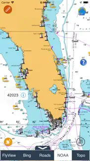
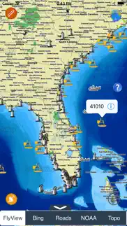
Global Overview: Explore an interactive world marine map that showcases all NOAA stations, buoys, and ships. Effortlessly locate the nearest stations and access comprehensive NOAA data with just a tap.
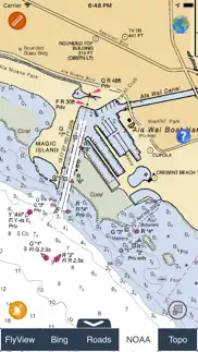
Detailed Marine Charts: Immerse yourself in detailed marine charts available at viewer.flytomap.com. The charts provide a visual representation of key information, making it easier for users to interpret and plan their maritime activities effectively.
Location-Specific Data: Whether using GPS or manually entering your preferred location, receive accurate and location-specific forecasts. The app ensures that you are well-informed about buoy data relevant to your chosen area.
Versatile Compatibility: Compatible with all iPhone, iPod, and iPad versions, the NOAA Buoy Data Viewer guarantees a seamless experience across various iOS devices.
Live Buoy Data: Stay updated with live buoy data, including information on wave conditions, wind dynamics, and atmospheric details. The app categorizes buoys based on proximity to your selected location for quick and easy access.
Tide Predictions and Moon Phases: Plan your maritime activities efficiently with tide predictions and moon phase information available at your fingertips.
For a complete list of buoy locations supported by the NOAA Buoy Data Viewer, visit http://www.ndbc.noaa.gov/.
Download now and empower your nautical adventures with the most comprehensive NOAA buoy data at your disposal.
- NOAA Buoys - Charts & Weather App User Reviews
- NOAA Buoys - Charts & Weather Pros
- NOAA Buoys - Charts & Weather Cons
- Is NOAA Buoys - Charts & Weather legit?
- Should I download NOAA Buoys - Charts & Weather?
- NOAA Buoys - Charts & Weather Screenshots
- Product details of NOAA Buoys - Charts & Weather
NOAA Buoys - Charts & Weather App User Reviews
What do you think about NOAA Buoys - Charts & Weather app? Ask the appsupports.co community a question about NOAA Buoys - Charts & Weather!
Please wait! Facebook NOAA Buoys - Charts & Weather app comments loading...
NOAA Buoys - Charts & Weather Pros
✓ Very UsefulBeing a commercial fisherman, I use this app on a daily basis and multiple times during the day. The update just made this app more useful by including nav charts! Keep up the great work!.Version: 1.1
✓ Very niceLove this buoy app, best and most comprehensive in the App store. It even has ship reports..Version: 1.0
✓ NOAA Buoys - Charts & Weather Positive ReviewsNOAA Buoys - Charts & Weather Cons
✗ Was a good appI use this app to forecast waves and boating conditions in the Gulf of Mexico and until this recent update it work good most of the time with a minor freeze everyone and then. After new update it crashed or freezes every time..Version: 1.4
✗ Used to be helpful...I used to use this app regularly to check on wind/sea conditions until recent upgrades. They have changed the map background and it is VERY slow to update. It now uses the “FlytoMap” display and has become almost useless. No longer recommended..Version: 1.1
✗ NOAA Buoys - Charts & Weather Negative ReviewsIs NOAA Buoys - Charts & Weather legit?
⚠ No. NOAA Buoys - Charts & Weather does not seem legit based on our analysis. This conclusion was arrived at by running over 53 NOAA Buoys - Charts & Weather user reviews through our NLP machine learning process to determine if users believe the app is legitimate or not. Based on this, AppSupports Legitimacy Score for NOAA Buoys - Charts & Weather is 27.4/100.
Is NOAA Buoys - Charts & Weather safe?
⚠ No. NOAA Buoys - Charts & Weather not seem very safe to us. This is based on our NLP analysis of over 53 user reviews sourced from the IOS appstore and the appstore cumulative rating of 1.5/5. AppSupports Safety Score for NOAA Buoys - Charts & Weather is 29.4/100.
Should I download NOAA Buoys - Charts & Weather?
⚠ We are not sure!
NOAA Buoys - Charts & Weather Screenshots

Product details of NOAA Buoys - Charts & Weather
- App Name:
- NOAA Buoys - Charts & Weather
- App Version:
- 1.9.1
- Developer:
- Flytomap
- Legitimacy Score:
- 27.4/100
- Safety Score:
- 29.4/100
- Content Rating:
- 4+ Contains no objectionable material!
- Category:
- Weather, Navigation
- Language:
- EN FR DE IT ES
- App Size:
- 24.18 MB
- Price:
- $2.99
- Bundle Id:
- com.flytomap.realNOAABuoy
- Relase Date:
- 09 September 2011, Friday
- Last Update:
- 09 April 2024, Tuesday - 21:59
- Compatibility:
- IOS 14.0 or later
Improved user interface..