

- 77.7LEGITIMACY SCORE
- 79.7SAFETY SCORE
- 4+CONTENT RATING
- $99.99PRICE
What is GIS Kit? Description of GIS Kit 1725 chars
Premier field collection and data viewer for iPhone and iPad.
- No desktop GIS software required.
- No prior GIS training required.
- Completely offline capable.
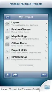
- Cache (download) open source topographic maps, street maps and satellite imagery straight from device.
- Import ESRI Shapefiles and KML/KMZ files including attributes.
- Attribute fields include: Alphanumeric (Description), Photos, numerical values, user defined list of values, addresses, websites, date & time, telephone number, check box.
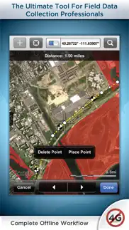
- Easily collect new point, line, and polygon features in the field by GPS or drawing manually.
- Enter attribute values for each feature and/or add new attribute types at time of collection.
- Create templates of user defined feature classes with custom attributes.
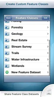
- Comes loaded with numerous example feature templates for professional use in Forestry, Wetland Delineation, Stream Surveys, and Real Estate.
- Import and export data wirelessly by email. Larger data sets can be imported/exported by connecting to any computer with itunes.
- Organize by projects and layers
- Best-in-class performance.
Check our website to see videos, documentation and more information about the "Pro" version. Please note that all the features of the GIS Pro version (such as Shapefile export) are available through in-app purchase in this app as well.
For Businesses:
Please note that a separate license is required for each user or each device that is used by multiple users. See http://www.apple.com/legal/itunes/us/terms.html for details. Also see http://www.apple.com/business/vpp for information on purchasing in volume.
Continued use of GPS running in the background can dramatically decrease battery life.
- GIS Kit App User Reviews
- GIS Kit Pros
- GIS Kit Cons
- Is GIS Kit legit?
- Should I download GIS Kit?
- GIS Kit Screenshots
- Product details of GIS Kit
GIS Kit App User Reviews
What do you think about GIS Kit app? Ask the appsupports.co community a question about GIS Kit!
Please wait! Facebook GIS Kit app comments loading...
GIS Kit Pros
✓ Worth every pennyI probably spent $100 on $2-$5 apps trying to find one that worked well with shape files and offline satellite images. All the other apps were lacking in one way or another. This app has worked flawlessly and is very stable. If you compare the price to an ArcMap license, it is a steal of a deal. I finally have access to offline maps in the field with all my critical shapefiles from the office..... On an iPhone 4s..Version: 3.14
✓ Good appIt crashed a couple of times when adding layer data. Found that if I switched off all but 1 layer I could keep adding new ones. Last project had 25 individual Track log layers on the same master project. Added waypoints with photos and exported it all to Google Earth KMZ. Worked a treat..Version: 3.18
✓ GIS Kit Positive ReviewsGIS Kit Cons
✗ Versátil y útilAplicación fácil de usar, fácil manejo de proyectos. Me encanta la versatilidad para exportar a nubes y email. Tiene pocas opciones de iconos y falta el despliegue de etiquetas..Version: 1.8
✗ Good App, Needs Better Support (GIS Pro)I have written the developer several times but haven't seen any improvement in capabilities. Each time the developer gives brief replies or states "I'll pass your suggestion on to the development team" and never gives another update or status of any feature requests. ~~~~~~~~~~~~~~~~~~~~~~~~~~~~~~~~~~~~~~~~~~~~~~~~~ I've been trying to export and import files using GISPro, GPSKit and ArcGIS Explorer. While exporting large files via e-mail the program (GISPro and GPSKit) will close without notice. I learned by reading your blog that this is a known problem and that exporting large files via iTunes works better. Q1: Do you have a user forum for exchanging other tips and information about using GIS Pro? Here are some more general questions that I have. I think these could be answered by other experienced users. Is there a way to order which items appear on top of other items? I purchased GIS Kit then upgraded to GIS Pro. My icon still shows GIS Kit although within the program at the first window it shows GIS Pro. Is there a tutorial on how to create and import custom icons? What other URL map sources are there that can be use with GIS Pro? Q2: Is there a way to export and import maps without lousing Feature Class types and attributes? I've been using GISPro for a wile now and I'm starting to get use to it. I've created my own set of Feature Classes. I've had a problem exporting maps and importing them back into GISPro. Each map item gets imported as a "Waypoint Subclass". All the fields are still there and pictures remain attached. When I change the Features class back to it's original sometimes the fields come up as duplicate and have a * added to the the end of the field name identifying it as an attribute that is not part of the feature class and will not be exported with SHP files. The Photo attribute is usually imported correctly. Almost all other attributes do not. Attributes that I created as lists or date do not import back in as a list. I've experienced this problem when exporting/importing from GISPro/GISPro (KMZ, GPX, Shape), GISPro/ArcGIS (KMZ, GPX, Shape), GPSKit/GISPro (KMZ, GPX). Is this a known issue? Some issues that should be fixed. Issue: GPS Pro crashes. When importing a new file, I swipe to delete listed files to keep phone memory clean. When the last file is deleted program closes. Issue: Project Name keeps changing. When creating new projects and renaming them, name change affects other projects. There are 3 fields that I can change the name and it changes the name of other project name fields. 1) when at the very first window (where you can swipe to change programs) you can click on the project name and it will allow you to edit the program name. 2) after selecting a project by taping on the picture of the project map, when the list [Layers, Feature Classes, Map Settings, Offline Maps, Project Units, GPS Settings] is visible, you can click on the project name and it will allow you to edit the program name. 3) When you select Layers the project name is still visible at the top, you can click on the project name and it will allow you to edit the program name. Suggested Updates: 1) Upgrade feature class field options to include video and audio/memo files? 2) Add the option to re-use a Free Hand Area for Caching a region using different settings (i.e. Selected Levels)? 3) Provide desktop based version of program for downloading offline maps and then transferring of the maps to mobile device? 4) Add an options for icon sizes? Maybe a scaling option? 5) Add the ability to create lines via GPS and create points, other lines, shapes manually at the same time (like GPS Kit)? 6) Add meta data to the points that create the GPS generated lines to support functions available in GPS Kit like "Color by Speed", "Color by Elevation". It would be nice to have GPS tracks created with either of these two options be able to export to GIS Pro with the color gradient. 7) Add a map layer with weather station actual location. Not sure how this options works with GPS Kit, you state that the weather information is provided by the national weather service I don't see where exactly is the station that generates the information is located? 8) Is it possible to take a snapshot of the weather station conditions (graphs included) and add this info to a way point? P.S. Barometric pressure needs to be added to the list. 9) You have Wave Height. Is it possible to add USGS stream gagging station information? 10) Add an option to allow you to over zoom in on a Tile without getting the gray "Map data not yet available" tile? Maybe add a icon to the corner of the scree that indicates that you are zoomed in as close as possible. ~~~~~~~~~~~~~~~~~~~~~~~~~~~~~~~~~~~~~~~~~~~~~~~~~ And the list keeps growing... 11) DropBox iCloud backups?.Version: 1.9.4
✗ GIS Kit Negative ReviewsIs GIS Kit legit?
✅ Yes. GIS Kit is legit, but not 100% legit to us. This conclusion was arrived at by running over 54 GIS Kit user reviews through our NLP machine learning process to determine if users believe the app is legitimate or not. Based on this, AppSupports Legitimacy Score for GIS Kit is 77.7/100.
Is GIS Kit safe?
✅ Yes. GIS Kit is quiet safe to use. This is based on our NLP analysis of over 54 user reviews sourced from the IOS appstore and the appstore cumulative rating of 4.0/5. AppSupports Safety Score for GIS Kit is 79.7/100.
Should I download GIS Kit?
✅ There have been no security reports that makes GIS Kit a dangerous app to use on your smartphone right now.
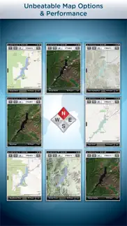
GIS Kit Screenshots
Product details of GIS Kit
- App Name:
- GIS Kit
- App Version:
- 3.31
- Developer:
- Garafa, LLC
- Legitimacy Score:
- 77.7/100
- Safety Score:
- 79.7/100
- Content Rating:
- 4+ Contains no objectionable material!
- Category:
- Navigation, Productivity
- Language:
- EN ES ZH
- App Size:
- 43.60 MB
- Price:
- $99.99
- Bundle Id:
- com.garafa.GIS
- Relase Date:
- 05 August 2011, Friday
- Last Update:
- 19 November 2019, Tuesday - 17:19
- Compatibility:
- IOS 9.0 or later
Bug fixes and optimizations..