

- 85.0LEGITIMACY SCORE
- 87.5SAFETY SCORE
- 4+CONTENT RATING
- FreePRICE
What is Singapore MRT Map Route? Description of Singapore MRT Map Route 2194 chars
Updated Thomson-East Coast Line (TE1 Woodlands North to Orchard) to the subway system
Singapore's MRT system is extending. By 2030, the MRT system will be more complex than you could image. It's good for all residents on our lovely island. But also will be a problem because we don't know how to travel the fastest when transfering stations.
Singapore MRT Map Route is designed to allows user to get the best route within a second. It will help you save a lot of time over years.
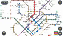
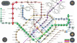
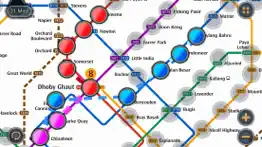
- View lastest Singapore MRT map
- Display the best route between two stations
- Automatically calculate estimated travel time
- Require no internet connection.
Updated to latest MRT system:
Downtown Line(Blue)
Bukit Panjang, Cashew, Hillview, Beauty World, King Albert Park, Sixth Avenue, Tan Kah Kee, Botanic Gardens, Stevens, Newton, Little India, Rochor, Bugis, Promenade, Bayfront, Downtown, Telok Ayer, Chinatown
Circle Line(Yellow)
Dhoby Ghaut, Bras Basah, Esplanade, Promenade, Nicoll Highway[C], Stadium, Mountbatten, Dakota, Paya Lebar, MacPherson, Tai Seng, Bartley, Serangoon, Lorong Chuan, Bishan, Marymount, Caldecott, Botanic Gardens, Farrer Road, Holland Village. Buona Vista, one-north, Kent Ridge, Haw Par Villa, Pasir Panjang, Labrador Park, Telok Blangah, HarbourFront
East West Line (Green)
Pasir Ris ,Tampines , Simei , Tanah Merah , Bedok , Kembangan , Eunos , Paya Lebar , Aljunied , Kallang , Lavender , Bugis , City Hall , Raffles Place , Tanjong Pagar , Outram Park , Tiong Bahru , Redhill , Queenstown , Commonwealth , Buona Vista , Dover ,Clementi , Jurong East , Chinese Garden , Lakeside , Boon Lay , Pioneer , Joo Koon, Expo,
Changi Airport
North South Line (Red)
Jurong East, Bukit Batok, Bukit Gombak, Choa Chu Kang, Yew Tee, Kranji, Marsiling, Woodlands, Admiralty, Sembawang, Canberra, Yishun, Khatib, Yio Chu Kang, Ang Mo Kio, Bishan, Braddell, Toa Payoh, Novena, Newton, Orchard, Somerset, Dhoby Ghaut, City Hall, Raffles Place, Marina Bay, Marina South Pier
North East Line (Purple)
HarbourFront, Outram Park, Chinatown, Clarke Quay, Dhoby Ghaut, Little India, Farrer Park, Boon Keng, Potong Pasir, Woodleigh, Serangoon, Kovan, Hougang, Buangkok, Sengkang, Punggol
- Singapore MRT Map Route App User Reviews
- Singapore MRT Map Route Pros
- Singapore MRT Map Route Cons
- Is Singapore MRT Map Route legit?
- Should I download Singapore MRT Map Route?
- Singapore MRT Map Route Screenshots
- Product details of Singapore MRT Map Route
Singapore MRT Map Route App User Reviews
What do you think about Singapore MRT Map Route app? Ask the appsupports.co community a question about Singapore MRT Map Route!
Please wait! Facebook Singapore MRT Map Route app comments loading...
Singapore MRT Map Route Pros
✓ WowThis is so much better than looking at the actual maps..Version: 1.5.5
✓ Great app.As a foreign traveler it’s nice to map out routes to all the great sights in SG!.Version: 2.3
✓ Singapore MRT Map Route Positive ReviewsSingapore MRT Map Route Cons
✗ Needs updatingApp needs to be updated with new MRT lines ie. blue downtown line.Version: 1.7.0
✗ So soNothing much.Version: 1.7.0
✗ Singapore MRT Map Route Negative ReviewsIs Singapore MRT Map Route legit?
✅ Yes. Singapore MRT Map Route is 100% legit to us. This conclusion was arrived at by running over 85 Singapore MRT Map Route user reviews through our NLP machine learning process to determine if users believe the app is legitimate or not. Based on this, AppSupports Legitimacy Score for Singapore MRT Map Route is 85.0/100.
Is Singapore MRT Map Route safe?
✅ Yes. Singapore MRT Map Route is quiet safe to use. This is based on our NLP analysis of over 85 user reviews sourced from the IOS appstore and the appstore cumulative rating of 4.5/5. AppSupports Safety Score for Singapore MRT Map Route is 87.5/100.
Should I download Singapore MRT Map Route?
✅ There have been no security reports that makes Singapore MRT Map Route a dangerous app to use on your smartphone right now.
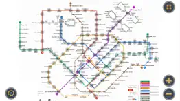
Singapore MRT Map Route Screenshots
Product details of Singapore MRT Map Route
- App Name:
- Singapore MRT Map Route
- App Version:
- 2.4.5
- Developer:
- Wan Peng
- Legitimacy Score:
- 85.0/100
- Safety Score:
- 87.5/100
- Content Rating:
- 4+ Contains no objectionable material!
- Category:
- Navigation, Travel
- Language:
- EN
- App Size:
- 96.86 MB
- Price:
- Free
- Bundle Id:
- com.momostorm.mrtfree
- Relase Date:
- 28 June 2012, Thursday
- Last Update:
- 12 July 2023, Wednesday - 00:58
- Compatibility:
- IOS 12.0 or later
Updated Thomson-East Coast Line (TE1 Woodlands North to Orchard) to the subway system Optimized calculation speed to improve the overall performance of the application. Fixed known issues and bugs to enhance the stability and reliability of the app....