

- 19.0LEGITIMACY SCORE
- 19.5SAFETY SCORE
- 4+CONTENT RATING
- $34.99PRICE
What is I-Boating:Australia & New Zealand - Gps Marine/Nautical Charts & Navigation Maps? Description of I-Boating:Australia & New Zealand - Gps Marine/Nautical Charts & Navigation Maps 3171 chars
This App offers offline nautical charts, lake & river navigation maps for fishing, kayaking, boating, yachting & sailing covering Australia and New Zealand. Marine navigation coverage includes marine vector charts, freshwater lake maps, and inland river maps (HD/1ft/3ft bathymetry included where available). First marine GPS app to have route assistance with Voice Prompts for marine navigation. You can create new boating routes or import existing GPX/KML routes. It supports Nautical Charts course up orientation. Includes Tide & Currents prediction.
►FEATURES
√ Download Beautiful & detailed Hardware/GPU accelerated vector charts (text stays upright on rotation)
√ Query details of Maritime object (Buoy, Lights, Obstruction etc).
√ Custom depth(Ft/Fathom/Meter) & distance units (km/mi/NM)
√ Custom Shallow Depth.
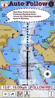
√ Record tracks, Autofollow with real-time track overlay & predicted path vector.
√ Voice Prompts for marine navigation (requires GPS )
√ 1ft / 3ft depth contour maps for anglers for selected lake maps. Useful for fishing/trolling(freshwater/saltwater).
√ Supports GPX/KML for boating route editing/import.
√ Tide & Currents.
√ Seamless chart quilting. Map details from Coastal, Approaches,Harbour, Inland Encs(rivers), and general ENC (Electronic Marine Charts) are automatically mapped to correct zoomlevel
√ Enter / import Waypoints.
► MAPS
Get all the details that you find in your chartplotters!
Please check website for latest new maps. Includes unlimited updates for 1 year.
Australia & New Zealand
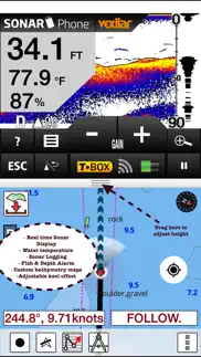
►Split Screen Sonar Display
√Live Sonar Image & Temperature
√Fish & Depth Alarms
√Fish Symbols
√Adjust temperature and depth units and offsets
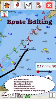
►ROUTE MANAGEMENT / TRIP PLANNING
√ Create New/Edit Routes
√ Reverse Routes
√ Enter,Move,Add,Delete,Rename Waypoints
√ Import GPX, KML & KMZ files
√ Plot/Edit Routes
√ Share/Export Routes,Tracks&Markers
►GPS FEATURES
√ Auto Follow
* Real Time Track Overlay
* Predicted Path Vector
* Course Up(Text stays upright)
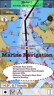
* Speed & Heading
√ Route Assistance With Voice Prompts
* Prompts when approaching a boating route marker
* Continous distance & ETA updates
* Alerts when sailing/boating off route
* Alerts when boating in wrong direction
√ Record Tracks
►TIDE & CURRENTS
* For US,Canada,UK,Germany&New Zealand
* High/Low Tides
* Tidal Current Prediction
* Active Current Stations
► Available Folios
√Arafura Sea
√Australian Antarctic Territory
√Bass Strait
√Bismarck Sea
√Coral Sea
√Great Barrier Reef
√Gulf of Carpentaria
√Indian Ocean
√Indonesia / Papua New Guinea
√New South Wales
√Northern Territory
√Papua New Guinea (incl. North East Coast)
√Port Phillip
√Queensland(Great Barrier Reef & Gulf of Carpentaria)
√Solomon Sea
√South Australia (Gulf St Vincent & Spencer Gulf)
√South Pacific Ocean
√Tasmania
√Tasman Sea
√Timor Sea
√Victoria
√Western Australia
► SHARING
* Share tracks/routes/markers on Facebook & Twitter
* Export tracks/routes/markers as compressed GPX files.
Battery disclaimer:
"Continued use of GPS running in the background can dramatically decrease battery life."
- I-Boating:Australia & New Zealand - Gps Marine/Nautical Charts & Navigation Maps App User Reviews
- I-Boating:Australia & New Zealand - Gps Marine/Nautical Charts & Navigation Maps Pros
- I-Boating:Australia & New Zealand - Gps Marine/Nautical Charts & Navigation Maps Cons
- Is I-Boating:Australia & New Zealand - Gps Marine/Nautical Charts & Navigation Maps legit?
- Should I download I-Boating:Australia & New Zealand - Gps Marine/Nautical Charts & Navigation Maps?
- I-Boating:Australia & New Zealand - Gps Marine/Nautical Charts & Navigation Maps Screenshots
- Product details of I-Boating:Australia & New Zealand - Gps Marine/Nautical Charts & Navigation Maps
I-Boating:Australia & New Zealand - Gps Marine/Nautical Charts & Navigation Maps App User Reviews
What do you think about I-Boating:Australia & New Zealand - Gps Marine/Nautical Charts & Navigation Maps app? Ask the appsupports.co community a question about I-Boating:Australia & New Zealand - Gps Marine/Nautical Charts & Navigation Maps!
Please wait! Facebook I-Boating:Australia & New Zealand - Gps Marine/Nautical Charts & Navigation Maps app comments loading...
I-Boating:Australia & New Zealand - Gps Marine/Nautical Charts & Navigation Maps Pros
The pros of the I-Boating:Australia & New Zealand - Gps Marine/Nautical Charts & Navigation Maps application were not found.
✓ I-Boating:Australia & New Zealand - Gps Marine/Nautical Charts & Navigation Maps Positive ReviewsI-Boating:Australia & New Zealand - Gps Marine/Nautical Charts & Navigation Maps Cons
The cons of the I-Boating:Australia & New Zealand - Gps Marine/Nautical Charts & Navigation Maps application were not found.
✗ I-Boating:Australia & New Zealand - Gps Marine/Nautical Charts & Navigation Maps Negative ReviewsIs I-Boating:Australia & New Zealand - Gps Marine/Nautical Charts & Navigation Maps legit?
I-Boating:Australia & New Zealand - Gps Marine/Nautical Charts & Navigation Maps scam ~ legit report is not ready. Please check back later.
Is I-Boating:Australia & New Zealand - Gps Marine/Nautical Charts & Navigation Maps safe?
I-Boating:Australia & New Zealand - Gps Marine/Nautical Charts & Navigation Maps safe report is not ready. Please check back later.
Should I download I-Boating:Australia & New Zealand - Gps Marine/Nautical Charts & Navigation Maps?
I-Boating:Australia & New Zealand - Gps Marine/Nautical Charts & Navigation Maps download report is not ready. Please check back later.
I-Boating:Australia & New Zealand - Gps Marine/Nautical Charts & Navigation Maps Screenshots
Product details of I-Boating:Australia & New Zealand - Gps Marine/Nautical Charts & Navigation Maps
- App Name:
- I-Boating:Australia & New Zealand - Gps Marine/Nautical Charts & Navigation Maps
- App Version:
- 57.0.0
- Developer:
- Bist LLC
- Legitimacy Score:
- 19.0/100
- Safety Score:
- 19.5/100
- Content Rating:
- 4+ Contains no objectionable material!
- Category:
- Navigation, Travel
- Language:
- NL EN FI FR DE NB
- App Size:
- 48.62 MB
- Price:
- $34.99
- Bundle Id:
- com.skiracer.aumarine
- Relase Date:
- 10 March 2016, Thursday
- Last Update:
- 10 March 2016, Thursday - 21:47
- Compatibility:
- IOS 7.0 or later
This app has been updated by Apple to display the Apple Watch app icon..