
- 92.8LEGITIMACY SCORE
- 93.3SAFETY SCORE
- 4+CONTENT RATING
- FreePRICE
What is National Parks Pocket Maps? Description of National Parks Pocket Maps 3580 chars
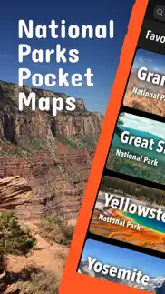
Be prepared! Plan your next trip to one of the great national parks. Download maps and guides before you venture into the Wi-Fi free wilderness.
Discover
- 500+ national parks, monuments, recreation areas, and all other National Park Service units
- 410+ neatly folded maps by the National Park Service
- 7,300+ campgrounds and campsites
- 11,400+ trails and trailheads
- 70,000+ points of interests
Plan
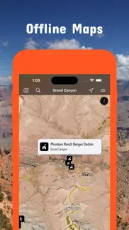
- Download maps, park brochures, and newspapers. These downloads are ready when you are offline and off the grid in the great outdoors.
- Download arbitrary map sections as offline packs.
- Photo galleries, panorama views.
- Share links to parks and maps with friends
Have fun
- GPS and GPX support: record your hikes, import GPX routes, tracks and waypoints for your hiking trails.
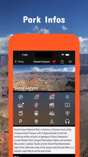
- Detailed national park information: alerts, news, visitor centers, campgrounds, driving directions, weather.
- Open your favorite maps app to get a route to the selected park.
- Current weather conditions, easy access to multi-day forecasts, sunrise and sunset times.
- Push notifications for park alerts, park news, weather warnings
So download maps and guides for:
Acadia
Arches
Badlands
Big Bend
Biscayne
Black Canyon of the Gunnison
Bryce Canyon
Canyonlands
Capitol Reef
Carlsbad Caverns
Channel Islands
Congaree,
Crater Lake
Death Valley
Denali
Dry Tortugas
Everglades
Gates of the Arctic
Glacier
Glacier Bay
Grand Canyon
Grand Teton
Great Basin
Great Smoky Mountains
Guadalupe Mountains
Hot Springs
Isle Royale
Joshua Tree
Katmai
Kenai Fjords
Kings Canyon
Lake Clark
Lassen Volcanic
Mammoth Cave
Mesa Verde
Mount Rainier
National Mall and Memorial Parks
North Cascades
Olympic
Petrified Forest
Pinnacles
Redwood
Rocky Mountain
Saguaro
Sequoia
Shenandoah
Theodore Roosevelt
Virgin Islands
Wind Cave
Yellowstone
Yosemite
Zion
There are lots of maps and brochures for national monuments, national preserves, national recreation areas, ..., like
Alagnak, Aniakchat, Antietam, Assateague Island, Aztec Ruins, Bandelier, Bering Land Bridge, Biscayne, Blue Ridge, Cabrillo, Canyon de Chelly, Cape Krusenstern, Capulin Volcano, Cedar Breaks, Chaco Culture, Chiricahua, Coronado, Curecanti, César E. Chávez, Devils Postpile, Dinosaur, El Malpais, El Morro, Florissant Fossil Beds, Fort Bowie, Fort Point, Gila Cliff Dwellings, Glen Canyon, Golden Gate, Golden Spike, Great Sand Dunes, Indiana Dunes, Lake Mead, Lava Beds, Mammoth Cave, Manzanar, Mojave, Montezuma Castle, Muir Woods, Natural Bridges, Navajo, Organ Pipe Cactus, Parashant, Pecos, Petroglyph, Point Reyes, Rainbow Bridge, Rosie the Riveter WWII Home Front, Salinas Pueblo Missions, San Antonio Missions, San Francisco Maritime, Santa Monica Mountains, Shenandoah, Sitka, Sunset Crater Volcano, Tuzigoot, Valles Caldera, Walnut Canyon, Whiskeytown, White Sands, Wupatki
and many more!
- FULL ACCESS is available for a for $3.49/three month (after a free 3-days trial period) or $2.49/two months or $7.49/year. You can subscribe and pay through your iTunes account. The account will be charged for renewal within 24-hours prior to the end of the current period, and identify the cost of the renewal. Your subscription will automatically renew unless canceled at least 24 hours before the end of the current period. Auto-renew can be turned off anytime by going to your Account Settings in iTunes after purchase.
- Continued use of GPS running in the background can dramatically decrease battery life.
LEGAL
Terms of Use: https://www.icoat.de/pocketmaps/terms
Privacy Policy: https://www.icoat.de/pocketmaps/privacy
- National Parks Pocket Maps App User Reviews
- National Parks Pocket Maps Pros
- National Parks Pocket Maps Cons
- Is National Parks Pocket Maps legit?
- Should I download National Parks Pocket Maps?
- National Parks Pocket Maps Screenshots
- Product details of National Parks Pocket Maps
National Parks Pocket Maps App User Reviews
What do you think about National Parks Pocket Maps app? Ask the appsupports.co community a question about National Parks Pocket Maps!
Please wait! Facebook National Parks Pocket Maps app comments loading...
National Parks Pocket Maps Pros
✓ Love the app but I lost compass at the top of my mapSo far it is the most accurate map I came across for hiking, but I seem to lose a Compass indicator at the top of my map on the left side? How can I get it back.Version: 5.8
✓ GreatI really enjoy this app and the info it has. Great maps of the places I love to hike. Dave.Version: 2.4.1
✓ National Parks Pocket Maps Positive ReviewsNational Parks Pocket Maps Cons
✗ Too many adsThere are just too many ads, pops up at almost every click.Version: 2.3
✗ Lots of ads, no way to filterJust for 30 seconds, lots of ads take up the screen real estate about 30%, and no way to filter only national parks..Version: 3.4
✗ National Parks Pocket Maps Negative ReviewsIs National Parks Pocket Maps legit?
✅ Yes. National Parks Pocket Maps is 100% legit to us. This conclusion was arrived at by running over 1,988 National Parks Pocket Maps user reviews through our NLP machine learning process to determine if users believe the app is legitimate or not. Based on this, AppSupports Legitimacy Score for National Parks Pocket Maps is 92.8/100.
Is National Parks Pocket Maps safe?
✅ Yes. National Parks Pocket Maps is quiet safe to use. This is based on our NLP analysis of over 1,988 user reviews sourced from the IOS appstore and the appstore cumulative rating of 4.6/5. AppSupports Safety Score for National Parks Pocket Maps is 93.3/100.
Should I download National Parks Pocket Maps?
✅ There have been no security reports that makes National Parks Pocket Maps a dangerous app to use on your smartphone right now.
National Parks Pocket Maps Screenshots

Product details of National Parks Pocket Maps
- App Name:
- National Parks Pocket Maps
- App Version:
- 6.3
- Developer:
- Alex Gugel
- Legitimacy Score:
- 92.8/100
- Safety Score:
- 93.3/100
- Content Rating:
- 4+ Contains no objectionable material!
- Category:
- Travel, Navigation
- Language:
- EN DE
- App Size:
- 88.96 MB
- Price:
- Free
- Bundle Id:
- de.icoat.npspocketmaps
- Relase Date:
- 25 September 2017, Monday
- Last Update:
- 12 March 2024, Tuesday - 19:41
- Compatibility:
- IOS 15.0 or later
Early Spring 2024 Updates: Big Bend, Smoky Mountains, Isle Royale, Sequoia & Kings Canyon, Yosemite, Zion. Updates: Contains the latest data by the National Park Service (NPS), Bureau of Land Management (BLM), United States Forest Service (USFS) and....