

- 93.1LEGITIMACY SCORE
- 93.6SAFETY SCORE
- 4+CONTENT RATING
- FreePRICE
What is GPS Camera 55. Field Survey? Description of GPS Camera 55. Field Survey 3933 chars
Capture and stamp photos with location, date, address, notes. Add hand drawn annotations. Search & filter your images by title, notes, tags or sort by proximity and date. Organize into collections/folders. Import existing photos from the photo library to restore their location, direction and even notes.
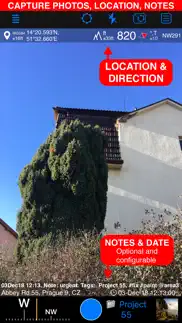
LOCATION OVERLAY
Supports decimal, dm or dms coordinates formats as well as UTM and MGRS.
True or magnetic heading. Degrees or mils.
Accuracy and altitude in either feet or meters.
CAMERA AND CAPTURE SETTINGS
Save photo automatically or open it in preview to annotate before saving.
Option to save copy of the photo to the photo library, either or both original and stamped photo.
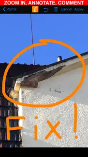
ANNOTATE AND COMMENT
Before or after saving the photo you can zoom in/out in the photo preview and draw on the image with your finger or Apple pencil.
Notes overlay for the photo supports Title, Note, Tags/Folder and Address.
Address can be pre-filled automatically based on the photo location or you can manually fill this field.
You can change notes and add more annotations later on (MENU > POINTS > tap on an image in the point row).
MENU > POINTS > tapping on a point row will open point editor where you can add an audio note for the image/point.
Timestamp options include many formats and you should always find your preferred languages between them as well.
Scan QR, Bar codes and texts and use scanned content for title or note field in the photo notes editor.
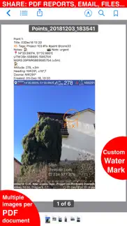
WATERMARK
Pro pack upgrade removes the basic version watermark and allows you to setup a watermark with your own image, text and colors, if needed.
SHARE AND EXCHANGE
You can select multiple points to share via MENU > POINTS or share the whole points collection via MENU > POINT COLLECTIONS.
Images can be shared with or without their location/notes text and with or without the location/notes overlay.
Saved/shared photo file names can be based on a photo title, note, address, folder/tags field name, folder/collection, coordinates, altitude, heading, capture date.
To transfer points/images in their entirety to another device, use the KMZ (Google Earth archive) export format - this allows to transfer points including images, image notes, annotations, audio notes, to another device.
PDF REPORTS
Generate and share PDF documents for the selected photos/points or whole collection/folder, with options for a number of images per page and photo descriptions.
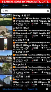
ORGANIZE, SEARCH & SORT
You can organize images into collections/folders. Existing images/points can be moved between collections.
MENU > POINTS screen enables you to search by point/image notes, address, tags fields, filter by creation month, sort by proximity or show points/images only for the specific collection.
IMPORT
MENU > IMPORT FROM LIBRARY will allow you to pick and import photo from the photo library and the app will do its best to parse tiff/exif/gps/iptc data in the photo to restore location, direction, notes for the stamp.
NAVIGATE
You can navigate to a point/image by opening it via MENU > POINTS and using Navigate button in the point editor screen.
MAP VIEW
Image/point location on a map can be reviewed by tapping on a MAP button in the point editor screen (MENU > POINTS > tap on a point row).
== PRO PACK UPGRADE ==
You can do a lot with the basic functions in the app. PRO PACK upgrade adds:
- Ability to create additional point/image collections.
- Enables sharing of more than 5 points/images at once.
- Export/import capabilities. In particular, KMZ export/import enables to transfer collections or selected waypoints between devices.
- Ability to save hand drawn annotations for the image.
- Extra protection of your work and privacy with PIN code or biometric based access options.
- Removes the basic version watermark and allows to apply a custom watermark with your image, text, colors.
Terms of Use: https://www.apple.com/legal/internet-services/itunes/dev/stdeula/
- GPS Camera 55. Field Survey App User Reviews
- GPS Camera 55. Field Survey Pros
- GPS Camera 55. Field Survey Cons
- Is GPS Camera 55. Field Survey legit?
- Should I download GPS Camera 55. Field Survey?
- GPS Camera 55. Field Survey Screenshots
- Product details of GPS Camera 55. Field Survey
GPS Camera 55. Field Survey App User Reviews
What do you think about GPS Camera 55. Field Survey app? Ask the appsupports.co community a question about GPS Camera 55. Field Survey!
Please wait! Facebook GPS Camera 55. Field Survey app comments loading...
GPS Camera 55. Field Survey Pros
✓ Good for businessTook me a while to get used to this…but, it does a great job for date time on photo..Version: 3.2
✓ CEI Inspection RoadwayFinally have a good app to keep track of items in my project. Google photos was not good enough. I have used this app from day one and like how the photos are filed..Version: 3.6
✓ GPS Camera 55. Field Survey Positive ReviewsGPS Camera 55. Field Survey Cons
✗ WCA few wsee.Version: 2.8
✗ Not simple to useExporting pictures should be instant Don’t waste money on upgrading.Version: 1.5
✗ GPS Camera 55. Field Survey Negative ReviewsIs GPS Camera 55. Field Survey legit?
✅ Yes. GPS Camera 55. Field Survey is 100% legit to us. This conclusion was arrived at by running over 1,977 GPS Camera 55. Field Survey user reviews through our NLP machine learning process to determine if users believe the app is legitimate or not. Based on this, AppSupports Legitimacy Score for GPS Camera 55. Field Survey is 93.1/100.
Is GPS Camera 55. Field Survey safe?
✅ Yes. GPS Camera 55. Field Survey is quiet safe to use. This is based on our NLP analysis of over 1,977 user reviews sourced from the IOS appstore and the appstore cumulative rating of 4.7/5. AppSupports Safety Score for GPS Camera 55. Field Survey is 93.6/100.
Should I download GPS Camera 55. Field Survey?
✅ There have been no security reports that makes GPS Camera 55. Field Survey a dangerous app to use on your smartphone right now.
GPS Camera 55. Field Survey Screenshots
Product details of GPS Camera 55. Field Survey
- App Name:
- GPS Camera 55. Field Survey
- App Version:
- 4.0
- Legitimacy Score:
- 93.1/100
- Safety Score:
- 93.6/100
- Content Rating:
- 4+ Contains no objectionable material!
- Category:
- Navigation, Photo & Video
- Language:
- EN FR DE JA PT RU ES
- App Size:
- 46.47 MB
- Price:
- Free
- Bundle Id:
- com.blocoware.geocamera
- Relase Date:
- 06 December 2018, Thursday
- Last Update:
- 13 February 2024, Tuesday - 11:09
- Compatibility:
- IOS 15.0 or later
◆ Customizable, pattern based file names for saving, sharing and exporting photos. Settings > Photo file name pattern: • Allows to set a file name pattern for a single file. • Batch file name pattern can be based on a single file name pattern....