


- 62.0LEGITIMACY SCORE
- 63.5SAFETY SCORE
- 4+CONTENT RATING
- FreePRICE
What is Elevation For Real? Description of Elevation For Real 2520 chars
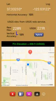
Get real-time elevation from your iOS device's GPS receiver and built-in geoid model.
As a bonus, we've also included access to the USGS Elevation Web Service which provides US ground elevation data. You'll be amazed at how, when you have a good view of the sky, Elevation For Real's internally generated elevation converges on the USGS value after just a short time. Outside the U.S., or on iOS devices with non-U.S. region settings, or if the USGS elevation service is unavailable, Shuttle Radar Topography Mission (SRTM) published elevation data is shown between 60°N and 56°S latitude.
Here are some more features:
- Real-time map which displays your location
- Estimated vertical and horizontal accuracy
- Spot elevation data displayed by tapping map
- English or metric units based on your region setting
- Start/Stop button
- One touch screenshots
- NO Third-Party Ads!
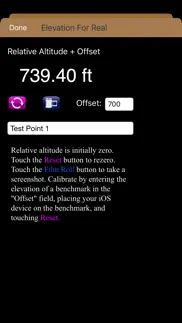
- Optional pressure altimeter (in-app purchase). Measure relative altitudes or calibrate to an elevation benchmark. Use indoors or out. Even works in Airplane Mode! Note: your iOS device must be equipped with a barometer to access pressure altimeter functionality. The iPhone 6 and later and the iPad Air 2 and later have barometers.
Download Elevation For Real today!
Notes:
1) homedatasheet.com, Inc. is not affiliated with USGS. USGS Elevation Web Service is available to the general public online, at no cost.
2) SRTM is provided by geonames.org. homedatasheet.com, Inc. is not affiliated with geonames.org. U.S.-based users should note that, in many instances, the SRTM data is not as accurate as USGS data. All users should note that, in certain locations, the SRTM dataset may be tens of meters or more in error.
3) ***The initial view of this app requires a GPS signal to work properly. A clear view of the sky is needed for GPS reception, and it may take several seconds to get a position fix. Elevation for Real will run on devices not equipped with a GPS receiver and GPS-equipped devices that are not receiving a GPS signal, but any resulting elevation readings will just be the approximate ground elevation at your location, even if you are several stories up in a tall building.
4) ***Any elevation measurements with personal safety or financial implications should be performed by professionals with professional GPS equipment. Elevation for Real is not intended to determine flood hazard. Consult a licensed professional in your jurisdiction, such as a surveyor or engineer, when dealing with flood risk.
- Elevation For Real App User Reviews
- Elevation For Real Pros
- Elevation For Real Cons
- Is Elevation For Real legit?
- Should I download Elevation For Real?
- Elevation For Real Screenshots
- Product details of Elevation For Real
Elevation For Real App User Reviews
What do you think about Elevation For Real app? Ask the appsupports.co community a question about Elevation For Real!
Please wait! Facebook Elevation For Real app comments loading...
Elevation For Real Pros
✓ Fun to knowInformative.Version: 0
✓ GreatI've only use this app a short time for search & Rescue. It's a great app. Works very well..Version: 5.0
✓ Elevation For Real Positive ReviewsElevation For Real Cons
✗ InconsistentLooked good at first, nice layout, etc. Temp. In 30s. Several side-by-side elevations clearly yielded flawed elevations (e.g., lower curb elevation shown higher, etc.). Enough unreliability to render the app moot for rough topographic use. Unfortunate..Version: 6.0
✗ Needs workI live right on the coast and the usgs seemed pretty close to being spot on, the real elevation was horribly inaccurate showing me at an altitude of almost 300ft. Please fix.Version: 0
✗ Elevation For Real Negative ReviewsIs Elevation For Real legit?
✅ Yes. Elevation For Real is legit, but not 100% legit to us. This conclusion was arrived at by running over 38 Elevation For Real user reviews through our NLP machine learning process to determine if users believe the app is legitimate or not. Based on this, AppSupports Legitimacy Score for Elevation For Real is 62.0/100.
Is Elevation For Real safe?
✅ Yes. Elevation For Real is quiet safe to use. This is based on our NLP analysis of over 38 user reviews sourced from the IOS appstore and the appstore cumulative rating of 3.2/5. AppSupports Safety Score for Elevation For Real is 63.5/100.
Should I download Elevation For Real?
✅ There have been no security reports that makes Elevation For Real a dangerous app to use on your smartphone right now.
Elevation For Real Screenshots
Product details of Elevation For Real
- App Name:
- Elevation For Real
- App Version:
- 10.0
- Developer:
- Homedatasheet.com, Inc.
- Legitimacy Score:
- 62.0/100
- Safety Score:
- 63.5/100
- Content Rating:
- 4+ Contains no objectionable material!
- Category:
- Navigation
- Language:
- EN
- App Size:
- 616.00 KB
- Price:
- Free
- Bundle Id:
- com.homedatasheet.elev4real
- Relase Date:
- 29 December 2009, Tuesday
- Last Update:
- 14 September 2023, Thursday - 02:34
- Compatibility:
- IOS 13.0 or later
Restores access to USGS Elevation Web Service..