Version 9.4.507 March 2024I use this app daily on trails in Colorado. We're continually improving it to be even more useful! This version adds the ability to view a weather report for any location.
What's new in iHikeGPS when compared with other available USA and Canada topo map apps?
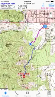
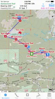
• Real Navigation Power: Unlike other apps that simply display waypoints and routes on a map, iHikeGPS empowers you to do real navigation to those waypoints and along those routes while receiving crucial information such as Estimated Time of Arrival, current bearing, and remaining distance and elevation gain to intermediate and final destinations. Use other available apps to find trails to hike. Use iHikeGPS when you are on the trail and away from cell service.
• With iHikeGPS, you receive the very latest US Forest Service maps at no additional charge. These maps show many new and more accurately placed trails, numbered Forest Service roads, buildings, and other important details. They show forested areas and inholdings so you know if you are on Forest Service land or private land. None of these maps are older than 2015, and many are even more recent. If you venture into Wilderness Areas or National Forest Service lands, these USFS maps will be invaluable to you. Don't settle for hiking apps which don't offer US Forest Service topo maps, or which say they include US Forest Service maps, but actually just give you the outdated 2013 versions.
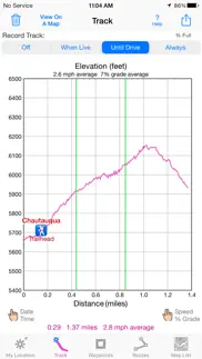
• You can view an elevation graph of your tracks and your routes with speed, % grade, and nearby waypoints shown on it.
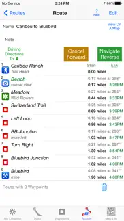
• You can create, import, edit, and navigate both on routes based on a recorded or imported path, and on routes based on a series of waypoints.
• iHikeGPS' s code size is kept very small by efficient programming, so in an emergency you can download it easily even over a weak cell connection.
• The current version of iHikeGPS runs on the latest devices and also on older devices with older versions of iOS , all the way back to devices such as the iPhone 6.
• There is never any confusion over what maps you have available offline. They are clearly listed by USGS quad name and shown on an overview map.
• Check the App Privacy section. We don't know who you are when you are using iHikeGPS. We never send your current location or your recorded track to our servers. Hence we cannot and don't use your location data. We cannot and don't provide your location data to anyone else. Unlike other mapping apps that profit from using your location data in ways that do not keep it private, iHikeGPS maintains the highest level of data confidentially..
Version 9.4.324 October 2023I use this app daily on trails in Colorado. We're continually improving it to be even more useful! With this version you can include both waypoints and routes in a single GPX file. Plus we've added many iPad human interface enhancements.
What's new in iHikeGPS when compared with other available USA and Canada topo map apps?
• Real Navigation Power: Unlike other apps that simply display waypoints and routes a map, iHikeGPS empowers you to do real navigation to those waypoints and along those routes while receiving crucial information such as Estimated Time of Arrival, current bearing, and remaining distance and elevation gain to intermediate and final destinations. Use other available apps to find trails to hike. Use iHikeGPS when you are on the trail and away from cell service.
• With iHikeGPS, you receive the very latest US Forest Service maps at no additional charge. These maps show many new and more accurately placed trails, numbered Forest Service roads, buildings, and other important details. They show forested areas and inholdings so you know if you are on Forest Service land or private land. None of these maps are older than 2015, and many are even more recent. If you venture into Wilderness Areas or National Forest Service lands, these USFS maps will be invaluable to you. Don't settle for hiking apps which don't offer US Forest Service topo maps, or which say they include US Forest Service maps, but actually just give you the outdated 2013 versions.
• You can view an elevation graph of your tracks and your routes with speed, % grade, and nearby waypoints shown on it.
• You can create, import, edit, and navigate both on routes based on a recorded or imported path, and on routes based on a series of waypoints.
• iHikeGPS' s code size is kept very small by efficient programming, so in an emergency you can download it easily even over a weak cell connection.
• The current version of iHikeGPS runs on the latest devices and also on older devices with older versions of iOS , all the way back to devices such as the iPhone 6.
• There is never any confusion over what maps you have available offline. They are clearly listed by USGS quad name and shown on an overview map.
• Check the App Privacy section. We don't know who you are when you are using iHikeGPS. We never send your current location or your recorded track to our servers. Hence we cannot and don't use your location data. We cannot and don't provide your location data to anyone else. Unlike other mapping apps that profit from using your location data in ways that do not keep it private, iHikeGPS maintains the highest level of data confidentially..
Version 9.4.118 September 2023I use this app daily on trails in Colorado. I'm continually improving it so it will be even more useful! This version is updated for iOS 17.
What's new in iHikeGPS when compared with other available USA and Canada topo map apps?
• Real Navigation Power: Unlike other apps that simply display waypoints and routes a map, iHikeGPS empowers you to do real navigation to those waypoints and along those routes while receiving crucial information such as Estimated Time of Arrival, current bearing, and remaining distance and elevation gain to intermediate and final destinations. Use other available apps to find trails to hike. Use iHikeGPS when you are on the trail and away from cell service.
• With iHikeGPS, you receive the very latest US Forest Service maps at no additional charge. These maps show many new and more accurately placed trails, numbered Forest Service roads, buildings, and other important details. They show forested areas and inholdings so you know if you are on Forest Service land or private land. None of these maps are older than 2015, and many are even more recent. If you venture into Wilderness Areas or National Forest Service lands, these USFS maps will be invaluable to you. Don't settle for hiking apps which don't offer US Forest Service topo maps, or which say they include US Forest Service maps, but actually just give you the outdated 2013 versions.
• You can view an elevation graph of your tracks and your routes with speed, % grade, and nearby waypoints shown on it.
• You can create, import, edit, and navigate both on routes based on a recorded or imported path, and on routes based on a series of waypoints.
• iHikeGPS' s code size is kept very small by efficient programming, so in an emergency you can download it easily even over a weak cell connection.
• The current version of iHikeGPS runs on the latest devices and also on older devices with older versions of iOS , all the way back to devices such as the iPhone 6.
• There is never any confusion over what maps you have available offline. They are clearly listed by USGS quad name and shown on an overview map.
• Check the App Privacy section. We don't know who you are when you are using iHikeGPS. We never send your current location or your recorded track to our servers. Hence we cannot and don't use your location data. We cannot and don't provide your location data to anyone else. Unlike other mapping apps that profit from using your location data in ways that do not keep it private, iHikeGPS maintains the highest level of data confidentially..
Version 9.3.420 July 2023I use this app daily on trails in Colorado. I'm continually improving it so it will be even more useful! This version adds the United States National Grid (MGRS) as a location coordinates choice.
What's new in iHikeGPS when compared with other available USA and Canada topo map apps?
• Real Navigation Power: Unlike other apps that simply display waypoints and routes a map, iHikeGPS empowers you to do real navigation to those waypoints and along those routes while receiving crucial information such as Estimated Time of Arrival, current bearing, and remaining distance and elevation gain to intermediate and final destinations.
• Don't settle for hiking apps which don't offer US Forest Service topo maps, or which say they include US Forest Service maps, but actually just give you the outdated 2013 versions. With iHikeGPS, you receive the very latest US Forest Service maps at no additional charge. These maps show many new and more accurately placed trails, numbered Forest Service roads, buildings, and other important details. They show forested areas and inholdings so you know if you are on Forest Service land or private land. None of these maps are older than 2015, and many are even more recent. If you venture into wilderness and National Forest Service areas, these up-to-date USFS maps will be invaluable to you.
• You can view an elevation graph of your tracks and your routes with waypoints, speed and % grade shown on it.
• You can create, import, edit, and navigate both on routes based on a recorded or imported path, and on routes based on a series of waypoints.
• iHikeGPS' s code size is kept very small by efficient programming, so in an emergency you can download it easily even over a weak cell connection.
• There is never any confusion over what maps you have available offline. They are clearly listed by USGS quad name and shown on an overview map.
• Check the App Privacy section. We don't know who you are when you are using iHikeGPS. We never send your current location or your recorded track to our servers. Hence we cannot and don't use your location data. We cannot and don't provide your location data to anyone else. Unlike other mapping apps that profit from using your location data in ways that do not keep it private, iHikeGPS maintains the highest level of data confidentially..
Version 9.3.311 September 2022I use this app daily on trails in Colorado. I'm continually improving it so it will be even more useful! This version adds Canada 50K maps for Saskatchewan, Manitoba, Ontario, and Quebec below 50° N latitude.
What's new in iHikeGPS when compared with other available USA and Canada topo map apps?
• You don't just see waypoints and routes displayed on the map, you can actually do real navigation to those waypoints and along those routes. You get information such as Estimated Time of Arrival, current bearing, and remaining distance and elevation gain to your intermediate and final destinations.
• Many apps don't offer US Forest Service topo maps at all. Others say they include US Forest Service maps, but actually just give you the old 2013 USFS maps. iHikeGPS gives you (with no additional charge) the very latest US Forest Service maps which show many new and more accurately placed trails, numbered Forest Service roads, buildings, and other important details. They show forested areas and inholdings so you know if you are on Forest Service land or private land. None of these maps are older than 2015, and many are even more recent. If you ever travel into wilderness and National Forest Service areas, then you will benefit hugely from having these up-to-date USFS maps available.
• You can view an elevation graph of your tracks and your routes with waypoints, speed and % grade shown on it.
• You can create, import, edit, and navigate both on routes based on a recorded or imported path, and on routes based on a series of waypoints.
• iHikeGPS' s code size is kept very small by efficient programming, so in an emergency you can download it easily even over a weak cell connection.
• There is never any confusion over what maps you have available offline. They are clearly listed by USGS quad name and shown on an overview map.
• Check the App Privacy section. We don't know who you are when you are using iHikeGPS. We never send your current location or your recorded track to our servers. Hence we cannot and don't use your location data. We cannot and don't provide your location data to anyone else. Many other mapping apps do profit from using your location data in ways that do not keep it private..
Version 9.3.218 February 2022I use this app daily on trails in Colorado. I'm continually improving it so it will be even more useful! This version displays the total storage space used by your downloaded maps.
What's new in iHikeGPS when compared with other available USA and Canada topo map apps?
• You don't just see waypoints and routes displayed on the map, you can actually do real navigation to those waypoints and along those routes. You get information such as Estimated Time of Arrival, current bearing, and remaining distance and elevation gain to your intermediate and final destinations.
• Many apps don't offer US Forest Service topo maps at all. Others say they include US Forest Service maps, but actually just give you the old 2013 USFS maps. iHikeGPS gives you (with no additional charge) the very latest US Forest Service maps which show many new and more accurately placed trails, numbered Forest Service roads, buildings, and other important details. They show forested areas and inholdings so you know if you are on Forest Service land or private land. None of these maps are older than 2015, and many are even more recent. If you ever travel into wilderness and National Forest Service areas, then you will benefit hugely from having these up-to-date USFS maps available.
• You can view an elevation graph of your tracks and your routes with waypoints, speed and % grade shown on it.
• You can create, import, edit, and navigate both on routes based on a recorded or imported path, and on routes based on a series of waypoints.
• iHikeGPS' s code size is kept very small by efficient programming, so in an emergency you can download it easily even over a weak cell connection.
• There is never any confusion over what maps you have available offline. They are clearly listed by USGS quad name and shown on an overview map.
• Check the App Privacy section. We don't know who you are when you are using iHikeGPS. We never send your current location or your recorded track to our servers. Hence we cannot and don't use your location data. We cannot and don't provide your location data to anyone else. Many other mapping apps do profit from using your location data in ways that do not keep it private..
Version 9.3.108 October 2021I use this app daily on trails in Colorado. I'm continually improving it so it will be even more useful! This version improves the human interface layout on the new iPad mini.
Only on older devices running iOS 9, map downloads quit working on 9/30/21 due to an expiring html security certificate. This version drops the use of that expired certificate, allowing iHikeGPS on those older devices to again function properly.
What's new in iHikeGPS when compared with other available USA and Canada topo map apps?
• You don't just see waypoints and routes displayed on the map, you can actually do real navigation to those waypoints and along those routes. You get information such as Estimated Time of Arrival, current bearing, and remaining distance and elevation gain to your intermediate and final destinations.
• Many apps don't offer US Forest Service topo maps at all. Others say they include US Forest Service maps, but actually just give you the old 2013 USFS maps. iHikeGPS gives you (with no additional charge) the very latest US Forest Service maps which show many new and more accurately placed trails, numbered Forest Service roads, buildings, and other important details. They show forested areas and inholdings so you know if you are on Forest Service land or private land. None of these maps are older than 2015, and many are even more recent. If you ever travel into wilderness and National Forest Service areas, then you will benefit hugely from having these up-to-date USFS maps available.
• You can view an elevation graph of your tracks and your routes with waypoints, speed and % grade shown on it.
• You can create, import, edit, and navigate both on routes based on a recorded or imported path, and on routes based on a series of waypoints.
• iHikeGPS' s code size is kept very small by efficient programming, so in an emergency you can download it easily even over a weak cell connection.
• There is never any confusion over what maps you have available offline. They are clearly listed by USGS quad name and shown on an overview map.
• Check the App Privacy section. We don't know who you are when you are using iHikeGPS. We never send your current location or your recorded track to our servers. Hence we cannot and don't use your location data. We cannot and don't provide your location data to anyone else. Many other mapping apps do profit from using your location data in ways that do not keep it private..
Version 9.2.508 July 2021I use this app daily on trails in Colorado. I'm continually improving it so it will be even more useful! With this version you can view the moon's phase and you can create a waypoint by simply entering an address.
What's new in iHikeGPS when compared with other available USA and Canada topo map apps?
• You don't just see waypoints and routes displayed on the map, you can actually do real navigation to those waypoints and along those routes. You get information such as Estimated Time of Arrival, current bearing, and remaining distance and elevation gain to your intermediate and final destinations.
• Many apps don't offer US Forest Service topo maps at all. Others say they include US Forest Service maps, but actually just give you the old 2013 USFS maps. iHikeGPS gives you (with no additional charge) the very latest US Forest Service maps which show many new and more accurately placed trails, numbered Forest Service roads, buildings, and other important details. They show forested areas and inholdings so you know if you are on Forest Service land or private land. None of these maps are older than 2015, and many are even more recent. If you ever travel into wilderness and National Forest Service areas, then you will benefit hugely from having these up-to-date USFS maps available.
• You can view an elevation graph of your tracks and your routes with waypoints, speed and % grade shown on it.
• You can create, import, edit, and navigate both on routes based on a recorded or imported path, and on routes based on a series of waypoints.
• iHikeGPS' s code size is kept very small by efficient programming, so in an emergency you can download it easily even over a weak cell connection.
• There is never any confusion over what maps you have available offline. They are clearly listed by USGS quad name and shown on an overview map.
• Check the App Privacy section. We don't know who you are when you are using iHikeGPS. We never send your current location or your recorded track to our servers. Hence we cannot and don't use your location data. We cannot and don't provide your location data to anyone else. Many other mapping apps do profit from using your location data in ways that do not keep it private..
Version 9.2.406 June 2021I use this app daily on trails in Colorado. I'm continually improving it so it will be even more useful! With this version you can view and share a sun & moon Azimuth/Elevation plot and rise & set times for any date & time and for any place on earth.
What's new in iHikeGPS when compared with other available USA and Canada topo map apps?
• You don't just see waypoints and routes displayed on the map, you can actually do real navigation to those waypoints and along those routes. You get information such as Estimated Time of Arrival, current bearing, and remaining distance and elevation gain to your intermediate and final destinations.
• Many apps don't offer US Forest Service topo maps at all. Others say they include US Forest Service maps, but actually just give you the old 2013 USFS maps. iHikeGPS gives you (with no additional charge) the very latest US Forest Service maps which show many new and more accurately placed trails, numbered Forest Service roads, buildings, and other important details. They show forested areas and inholdings so you know if you are on Forest Service land or private land. None of these maps are older than 2015, and many are even more recent. If you ever travel into wilderness and National Forest Service areas, then you will benefit hugely from having these up-to-date USFS maps available.
• You can view an elevation graph of your tracks and your routes with waypoints, speed and % grade shown on it.
• You can create, import, edit, and navigate both on routes based on a recorded or imported path, and on routes based on a series of waypoints.
• iHikeGPS' s code size is kept very small by efficient programming, so in an emergency you can download it easily even over a weak cell connection.
• There is never any confusion over what maps you have available offline. They are clearly listed by USGS quad name and shown on an overview map.
• Check the App Privacy section. We don't know who you are when you are using iHikeGPS. We never send your current location or your recorded track to our servers. Hence we cannot and don't use your location data. We cannot and don't provide your location data to anyone else. Many other mapping apps do profit from using your location data in ways that do not keep it private..
Version 9.2.116 March 2021I use this app daily on trails in Colorado. I'm continually improving it so it will be even more useful! This version lets you import workouts and routes from .TCX files.
What's new in iHikeGPS when compared with other available USA and Canada topo map apps?
• You don't just see waypoints and routes displayed on the map, you can actually do real navigation to those waypoints and along those routes. You get information such as Estimated Time of Arrival, current bearing, and remaining distance and elevation gain to your intermediate and final destinations.
• Many apps don't offer US Forest Service topo maps at all. Others say they include US Forest Service maps, but actually just give you the old 2013 USFS maps. iHikeGPS gives you (with no additional charge) the very latest US Forest Service maps which show many new and more accurately placed trails, numbered Forest Service roads, buildings, and other important details. They show forested areas and inholdings so you know if you are on Forest Service land or private land. None of these maps are older than 2015, and many are even more recent. If you ever travel into wilderness and National Forest Service areas, then you will benefit hugely from having these up-to-date USFS maps available.
• You can view an elevation graph of your tracks and your routes with waypoints, speed and % grade shown on it.
• You can create, import, edit, and navigate both on routes based on a recorded or imported path, and on routes based on a series of waypoints.
• iHikeGPS' s code size is kept very small by efficient programming, so in an emergency you can download it easily even over a weak cell connection.
• There is never any confusion over what maps you have available offline. They are clearly listed by USGS quad name and shown on an overview map.
• Check the App Privacy section. We don't know who you are when you are using iHikeGPS. We never send your current location or your recorded track to our servers. Hence we cannot and don't use your location data. We cannot and don't provide your location data to anyone else. Many other mapping apps do profit from using your location data in ways that do not keep it private..
Version 9.2.005 February 2021I use this app daily on hiking trails in Colorado. I'm continually improving it so it will be even more useful! This version adds the ability to see the % grade of any portion of a trail on the Track graph and the Route elevation graph.
What's new in iHikeGPS when compared with other available USA and Canada topo map apps?
• You don't just see waypoints and routes displayed on the map, you can actually do real navigation to those waypoints and along those routes. You get information such as Estimated Time of Arrival, current bearing, and remaining distance and elevation gain to your intermediate and final destinations.
• Many apps don't offer US Forest Service topo maps at all. Others say they include US Forest Service maps, but actually just give you the old 2013 USFS maps. iHikeGPS gives you (with no additional charge) the very latest US Forest Service maps which show many new and more accurately placed trails, numbered Forest Service roads, buildings, and other important details. They show forested areas and inholdings so you know if you are on Forest Service land or private land. None of these maps are older than 2015, and many are even more recent. If you ever travel into wilderness and National Forest Service areas, then you will benefit hugely from having these up-to-date USFS maps available.
• You can view an elevation graph of your tracks and your routes with waypoints and % grade shown on it.
• You can create, import, edit, and navigate both on routes based on a recorded or imported path, and on routes based on a series of waypoints.
• iHikeGPS' s code size is kept very small by efficient programming, so in an emergency you can download it easily even over a weak cell connection.
• There is never any confusion over what maps you have available offline. They are clearly listed by USGS quad name and shown on an overview map..
Version 9.1.122 November 2020I use this app daily on hiking trails in Colorado. I'm continually improving it so it will be even more useful! This version changes the background color of the Estimated Time of Arrival according to the sun's position to warn you if you will be arriving after the sun sets at your destination. Updated for the iPhone 12.
What's new in iHikeGPS when compared with other available USA and Canada topo map apps?
• You don't just see waypoints and routes displayed on the map, you can actually do real navigation to those waypoints and along those routes. You get information such as Estimated Time of Arrival, current bearing, and remaining distance and elevation gain to your intermediate and final destinations.
• Many apps don't offer US Forest Service topo maps at all. Others say they include US Forest Service maps, but actually just give you the old 2013 USFS maps. iHikeGPS gives you (with no additional charge) the very latest US Forest Service maps which show many new and more accurately placed trails, numbered Forest Service roads, buildings, and other important details. They show forested areas and inholdings so you know if you are on Forest Service land or private land. None of these maps are older than 2015, and many are even more recent. If you ever travel into wilderness and National Forest service areas, then you will benefit hugely from having these up-to-date USFS maps available.
• You can view an elevation graph of your tracks and your routes with waypoints shown on it.
• You can create, import, edit, and navigate both on routes based on a recorded or imported path, and on routes based on a series of waypoints.
• iHikeGPS' s code size is kept very small by efficient programming, so in an emergency you can download it easily even over a weak cell connection.
• There is never any confusion over what maps you have available offline. They are clearly listed by USGS quad name and shown on an overview map..
Version 9.1.022 September 2020I use this app daily on hiking trails in Colorado. I'm continually improving it so it will be even more useful! This version is updated for iOS 14.
What's new in iHikeGPS when compared with other available USA and Canada topo map apps?
• You don't just see waypoints and routes displayed on the map, you can actually do real navigation to those waypoints and along those routes. You get information such as Estimated Time of Arrival, current bearing, and remaining distance and elevation gain to your intermediate and final destinations.
• Many apps don't offer US Forest Service topo maps at all. Others say they include US Forest Service maps, but actually just give you the old 2013 USFS maps. iHikeGPS gives you (with no additional charge) the very latest US Forest Service maps which show many new and more accurately placed trails, numbered Forest Service roads, buildings, and other important details. They show forested areas and inholdings so you know if you are on Forest Service land or private land. None of these maps are older than 2015, and many are even more recent. If you ever travel into wilderness and National Forest service areas, then you will benefit hugely from having these up-to-date USFS maps available.
• You can view an elevation graph of your tracks and your routes with waypoints shown on it.
• You can create, import, edit, and navigate both on routes based on a recorded or imported path, and on routes based on a series of waypoints.
• iHikeGPS' s code size is kept very small by efficient programming, so in an emergency you can download it easily even over a weak cell connection.
• There is never any confusion over what maps you have available offline. They are clearly listed by USGS quad name and shown on an overview map..