Version 9.4.507 March 2024I use iHikeGPS on trails daily. I'm continually improving it so it will be even more useful! This version adds the ability to view a weather report for any location.
What's new in iHikeGPS NZ compared with other available New Zealand topo map apps?
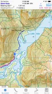
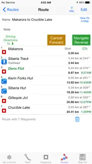
• Real Navigation Power: Unlike other apps that simply display waypoints and routes on a map, iHikeGPS NZ empowers you to do real navigation to those waypoints and along those routes while receiving crucial information such as Estimated Time of Arrival, current bearing, and remaining distance and elevation gain to intermediate and final destinations. Use iHikeGPS NZ when you are on the trail and away from cell service.
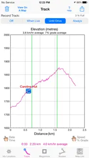
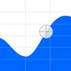
• You can view an elevation graph of your tracks and your routes with waypoints, speed and % grade shown on it.
• You can create, import, edit, and navigate both on routes based on a recorded or imported path, and on routes based on a series of waypoints.
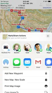
• There is never any confusion over what maps you have available offline. They are clearly listed and shown on an overview map.
• Includes 250K scale topo maps for Australia with no additional charge.
• iHikeGPS NZ' s code size is kept very small by efficient programming so in an emergency, you can download it easily even over a weak cell connection.
• The current version of iHikeGPS NZ runs on the latest devices and also on older devices with older versions of iOS , all the way back to devices such as the iPhone 6.
• Check the App Privacy section. We don't know who you are when you are using iHikeGPS NZ. We never send your current location or your recorded track to our servers. Hence we cannot and don't use your location data. We cannot and don't provide your location data to anyone else. Unlike other mapping apps that profit from using your location data in ways that do not keep it private, iHikeGPS NZ maintains the highest level of data confidentially..
Version 9.4.324 October 2023I use iHikeGPS on trails daily. I'm continually improving it so it will be even more useful! With this version you can include both waypoints and routes in a single GPX file. Plus we've added many iPad human interface enhancements.
What's new in iHikeGPS NZ compared with other available New Zealand topo map apps?
• Real Navigation Power: Unlike other apps that simply display waypoints and routes a map, iHikeGPS NZ empowers you to do real navigation to those waypoints and along those routes while receiving crucial information such as Estimated Time of Arrival, current bearing, and remaining distance and elevation gain to intermediate and final destinations. Use iHikeGPS NZ when you are on the trail and away from cell service.
• You can view an elevation graph of your tracks and your routes with waypoints, speed and % grade shown on it.
• You can create, import, edit, and navigate both on routes based on a recorded or imported path, and on routes based on a series of waypoints.
• There is never any confusion over what maps you have available offline. They are clearly listed and shown on an overview map.
• Includes 250K scale topo maps for Australia with no additional charge.
• iHikeGPS NZ' s code size is kept very small by efficient programming so in an emergency, you can download it easily even over a weak cell connection.
• The current version of iHikeGPS NZ runs on the latest devices and also on older devices with older versions of iOS , all the way back to devices such as the iPhone 6.
• Check the App Privacy section. We don't know who you are when you are using iHikeGPS NZ. We never send your current location or your recorded track to our servers. Hence we cannot and don't use your location data. We cannot and don't provide your location data to anyone else. Unlike other mapping apps that profit from using your location data in ways that do not keep it private, iHikeGPS NZ maintains the highest level of data confidentially..
Version 9.4.003 September 2023I use iHikeGPS on trails daily. I'm continually improving it so it will be even more useful! This version has user interface improvements and minor bug fixes.
What's new in iHikeGPS NZ compared with other available New Zealand topo map apps?
• Real Navigation Power: Unlike other apps that simply display waypoints and routes a map, iHikeGPS NZ empowers you to do real navigation to those waypoints and along those routes while receiving crucial information such as Estimated Time of Arrival, current bearing, and remaining distance and elevation gain to intermediate and final destinations. Use iHikeGPS NZ when you are on the trail and away from cell service.
• You can view an elevation graph of your tracks and your routes with waypoints, speed and % grade shown on it.
• You can create, import, edit, and navigate both on routes based on a recorded or imported path, and on routes based on a series of waypoints.
• There is never any confusion over what maps you have available offline. They are clearly listed and shown on an overview map.
• Includes 250K scale topo maps for Australia with no additional charge.
• iHikeGPS NZ' s code size is kept very small by efficient programming so in an emergency, you can download it easily even over a weak cell connection.
• The current version of iHikeGPS NZ runs on the latest devices and also on older devices with older versions of iOS , all the way back to devices such as the iPhone 6.
• Check the App Privacy section. We don't know who you are when you are using iHikeGPS NZ. We never send your current location or your recorded track to our servers. Hence we cannot and don't use your location data. We cannot and don't provide your location data to anyone else. Unlike other mapping apps that profit from using your location data in ways that do not keep it private, iHikeGPS NZ maintains the highest level of data confidentially..
Version 9.3.311 September 2022I use iHikeGPS on trails daily. I'm continually improving it so it will be even more useful! This version has a few user interface improvements.
What's new in iHikeGPS NZ compared with other available New Zealand topo map apps?
• You don't just see waypoints and routes displayed on the map, you can actually do real navigation to those waypoints and along those routes. You get information such as Estimated Time of Arrival, current bearing, and remaining distance and elevation gain to your intermediate and final destinations.
• You can view an elevation graph of your tracks and your routes with waypoints shown on it.
• You can create, import, edit, and navigate on both routes based on a recorded or imported path, and routes based on a series of waypoints.
• There is never any confusion over what maps you have available offline for use when you don't have an Internet connection. They are clearly listed and shown on an overview map.
• iHikeGPS NZ' s code size is kept very small by efficient programming so in an emergency, you can download it easily even over a weak cell connection.
• Includes 250K scale topo maps for Australia with no additional charge.
• Check the App Privacy section. We don't know who you are when you are using iHikeGPS NZ. We never send your current location or your recorded track to our servers. Hence we cannot and don't use your location data. We cannot and don't provide your location data to anyone else. Many other mapping apps do profit from using your location data in ways that do not keep it private..
Version 9.3.218 February 2022I use iHikeGPS NZ on trails daily. I'm continually improving it so it will be even more useful! This version displays the total storage space used by your downloaded maps.
What's new in iHikeGPS NZ compared with other available New Zealand topo map apps?
• You don't just see waypoints and routes displayed on the map, you can actually do real navigation to those waypoints and along those routes. You get information such as Estimated Time of Arrival, current bearing, and remaining distance and elevation gain to your intermediate and final destinations.
• You can view an elevation graph of your tracks and your routes with waypoints shown on it.
• You can create, import, edit, and navigate on both routes based on a recorded or imported path, and routes based on a series of waypoints.
• There is never any confusion over what maps you have available offline for use when you don't have an Internet connection. They are clearly listed and shown on an overview map.
• iHikeGPS NZ' s code size is kept very small by efficient programming so in an emergency, you can download it easily even over a weak cell connection.
• Includes topo maps for Australia with no additional charge.
• Check the App Privacy section. We don't know who you are when you are using iHikeGPS NZ. We never send your current location or your recorded track to our servers. Hence we cannot and don't use your location data. We cannot and don't provide your location data to anyone else. Many other mapping apps do profit from using your location data in ways that do not keep it private..
Version 9.3.108 October 2021I use iHikeGPS NZ on trails daily. I'm continually improving it so it will be even more useful! This version improves the human interface layout on the new iPad mini.
Only on older devices running iOS 9, map downloads quit working on 9/30/21 due to an expiring html security certificate. This version drops the use of that expired certificate, allowing iHikeGPS NZ on those older devices to again function properly.
What's new in iHikeGPS NZ compared with other available New Zealand topo map apps?
• You don't just see waypoints and routes displayed on the map, you can actually do real navigation to those waypoints and along those routes. You get information such as Estimated Time of Arrival, current bearing, and remaining distance and elevation gain to your intermediate and final destinations.
• You can view an elevation graph of your tracks and your routes with waypoints shown on it.
• You can create, import, edit, and navigate on both routes based on a recorded or imported path, and routes based on a series of waypoints.
• There is never any confusion over what maps you have available offline for use when you don't have an Internet connection. They are clearly listed and shown on an overview map.
• iHikeGPS NZ' s code size is kept very small by efficient programming so in an emergency, you can download it easily even over a weak cell connection.
• Includes topo maps for Australia with no additional charge.
• Check the App Privacy section. We don't know who you are when you are using iHikeGPS NZ. We never send your current location or your recorded track to our servers. Hence we cannot and don't use your location data. We cannot and don't provide your location data to anyone else. Many other mapping apps do profit from using your location data in ways that do not keep it private..
Version 9.2.508 July 2021I use iHikeGPS NZ on trails daily. I'm continually improving it so it will be even more useful! With this version you can view the moon's phase and you can create a waypoint by simply entering an address.
What's new in iHikeGPS NZ compared with other available New Zealand topo map apps?
• You don't just see waypoints and routes displayed on the map, you can actually do real navigation to those waypoints and along those routes. You get information such as Estimated Time of Arrival, current bearing, and remaining distance and elevation gain to your intermediate and final destinations.
• You can view an elevation graph of your tracks and your routes with waypoints shown on it.
• You can create, import, edit, and navigate on both routes based on a recorded or imported path, and routes based on a series of waypoints.
• There is never any confusion over what maps you have available offline for use when you don't have an Internet connection. They are clearly listed and shown on an overview map.
• iHikeGPS NZ' s code size is kept very small by efficient programming so in an emergency, you can download it easily even over a weak cell connection.
• Includes topo maps for Australia with no additional charge.
• Check the App Privacy section. We don't know who you are when you are using iHikeGPS NZ. We never send your current location or your recorded track to our servers. Hence we cannot and don't use your location data. We cannot and don't provide your location data to anyone else. Many other mapping apps do profit from using your location data in ways that do not keep it private..
Version 9.2.213 May 2021I use iHikeGPS NZ on trails daily. I'm continually improving it so it will be even more useful! This version shows the estimated accuracy of the course and compass heading readings so you can know when you need to move away from magnetic materials or recalibrate the internal compass.
What's new in iHikeGPS NZ compared with other available New Zealand topo map apps?
• You don't just see waypoints and routes displayed on the map, you can actually do real navigation to those waypoints and along those routes. You get information such as Estimated Time of Arrival, current bearing, and remaining distance and elevation gain to your intermediate and final destinations.
• You can view an elevation graph of your tracks and your routes with waypoints shown on it.
• You can create, import, edit, and navigate on both routes based on a recorded or imported path, and routes based on a series of waypoints.
• There is never any confusion over what maps you have available offline for use when you don't have an Internet connection. They are clearly listed and shown on an overview map.
• iHikeGPS NZ' s code size is kept very small by efficient programming so in an emergency, you can download it easily even over a weak cell connection.
• Includes topo maps for Australia with no additional charge.
• Check the App Privacy section. We don't know who you are when you are using iHikeGPS NZ. We never send your current location or your recorded track to our servers. Hence we cannot and don't use your location data. We cannot and don't provide your location data to anyone else. Many other mapping apps do profit from using your location data in ways that do not keep it private..
Version 9.2.116 March 2021I use iHikeGPS NZ on trails daily. I'm continually improving it so it will be even more useful! This version lets you import workouts and routes from .TCX files.
What's new in iHikeGPS NZ compared with other available New Zealand topo map apps?
• You don't just see waypoints and routes displayed on the map, you can actually do real navigation to those waypoints and along those routes. You get information such as Estimated Time of Arrival, current bearing, and remaining distance and elevation gain to your intermediate and final destinations.
• You can view an elevation graph of your tracks and your routes with waypoints shown on it.
• You can create, import, edit, and navigate on both routes based on a recorded or imported path, and routes based on a series of waypoints.
• There is never any confusion over what maps you have available offline for use when you don't have an Internet connection. They are clearly listed and shown on an overview map.
• iHikeGPS NZ' s code size is kept very small by efficient programming so in an emergency, you can download it easily even over a weak cell connection.
• Includes topo maps for Australia with no additional charge.
• Check the App Privacy section. We don't know who you are when you are using iHikeGPS NZ. We never send your current location or your recorded track to our servers. Hence we cannot and don't use your location data. We cannot and don't provide your location data to anyone else. Many other mapping apps do profit from using your location data in ways that do not keep it private..
Version 9.1.122 November 2020I use iHikeGPS daily while hiking. I'm continually improving it so it will be even more useful! This version changes the background color of the Estimated Time of Arrival according to the sun's position to warn you if you will be arriving after the sun sets at your destination. Updated for the iPhone 12.
What's new in iHikeGPS NZ compared with other available New Zealand topo map apps?
• You don't just see waypoints and routes displayed on the map, you can actually do real navigation to those waypoints and along those routes. You get information such as Estimated Time of Arrival, current bearing, and remaining distance and elevation gain to your intermediate and final destinations.
• You can view an elevation graph of your tracks and your routes with waypoints shown on it.
• You can create, import, edit, and navigate on both routes based on a recorded or imported path, and routes based on a series of waypoints.
• There is never any confusion over what maps you have available offline for use when you don't have an Internet connection. They are clearly listed and shown on an overview map.
• iHikeGPS NZ' s code size is kept very small by efficient programming so in an emergency, you can download it easily even over a weak cell connection.
• Includes topo maps for Australia with no additional charge..