Version 9.4.507 March 2024I'm continually improving this app so it will be even more useful! This version adds the ability to view a weather report for any location.
What's new in iSailGPS when compared with other available NOAA chart apps?
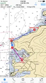
• You don't just see waypoints and routes displayed on the chart, you can actually do real great circle navigation to those waypoints and along those routes. You get information such as Estimated Time of Arrival, current bearing, heading and cross-track error, and remaining distances to your intermediate and final destinations.
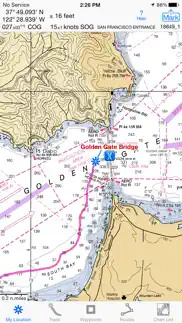
• You don't just see individual charts. Whenever the map projection is compatible (which it is most cases), you can see adjacent charts with their margins removed stitched together seamlessly, even when the chart scales are different. For example you can see the approach chart and the corresponding harbor detail chart both together on the same screen.
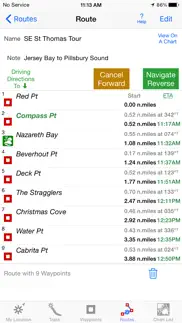
• You can create, import, edit, export, and navigate both on routes based on a recorded or imported path, and on routes based on a series of waypoints.
• iSailGPS's code size is kept very small by efficient programming so in an emergency, you can download it easily even over a weak cell connection.
• The current version of iSailGPS runs on the latest devices and also on older devices with older versions of iOS , all the way back to devices such as the iPhone 6.
• There is never any confusion over what charts you have available offline. They are clearly listed by NOAA chart name and number, and shown on an overview map.
• Check the App Privacy section. We don't know who you are when you are using iSailGPS. We never send your current location or your recorded track to our servers. Hence we cannot and don't use your location data. We cannot and don't provide your location data to anyone else. Unlike other mapping apps that profit from using your location data in ways that do not keep it private, iSailGPS maintains the highest level of data confidentially..
Version 9.4.428 January 2024I'm continually improving this app so it will be even more useful! This version is updated for iOS 17.3.
What's new in iSailGPS when compared with other available NOAA chart apps?
• You don't just see waypoints and routes displayed on the chart, you can actually do real great circle navigation to those waypoints and along those routes. You get information such as Estimated Time of Arrival, current bearing and heading, and remaining distance to your intermediate and final destinations.
• You don't just see individual charts. Whenever the map projection is compatible (which it is most cases), you can see adjacent charts with their margins removed stitched together seamlessly, even when the chart scales are different. For example you can see the approach chart and the corresponding harbor detail chart both together on the same screen.
• You can create, import, edit, export, and navigate both on routes based on a recorded or imported path, and on routes based on a series of waypoints.
• iSailGPS's code size is kept very small by efficient programming so in an emergency, you can download it easily even over a weak cell connection.
• The current version of iSailGPS runs on the latest devices and also on older devices with older versions of iOS , all the way back to devices such as the iPhone 6.
• There is never any confusion over what charts you have available offline. They are clearly listed by NOAA chart name and number, and shown on an overview map.
• Check the App Privacy section. We don't know who you are when you are using iSailGPS. We never send your current location or your recorded track to our servers. Hence we cannot and don't use your location data. We cannot and don't provide your location data to anyone else. Unlike other mapping apps that profit from using your location data in ways that do not keep it private, iSailGPS maintains the highest level of data confidentially..
Version 9.4.324 October 2023I'm continually improving this app so it will be even more useful! With this version you can include both waypoints and routes in a single GPX file. Plus we've added many iPad human interface enhancements.
What's new in iSailGPS when compared with other available NOAA chart apps?
• You don't just see waypoints and routes displayed on the chart, you can actually do real great circle navigation to those waypoints and along those routes. You get information such as Estimated Time of Arrival, current bearing and heading, and remaining distance to your intermediate and final destinations.
• You don't just see individual charts. Whenever the map projection is compatible (which it is most cases), you can see adjacent charts with their margins removed stitched together seamlessly, even when the chart scales are different. For example you can see the approach chart and the corresponding harbor detail chart both together on the same screen.
• You can create, import, edit, export, and navigate both on routes based on a recorded or imported path, and on routes based on a series of waypoints.
• iSailGPS's code size is kept very small by efficient programming so in an emergency, you can download it easily even over a weak cell connection.
• The current version of iSailGPS runs on the latest devices and also on older devices with older versions of iOS , all the way back to devices such as the iPhone 6.
• There is never any confusion over what charts you have available offline. They are clearly listed by NOAA chart name and number, and shown on an overview map.
• Check the App Privacy section. We don't know who you are when you are using iSailGPS. We never send your current location or your recorded track to our servers. Hence we cannot and don't use your location data. We cannot and don't provide your location data to anyone else. Unlike other mapping apps that profit from using your location data in ways that do not keep it private, iSailGPS maintains the highest level of data confidentially..
Version 9.4.118 September 2023I'm continually improving this app so it will be even more useful! This version is updated for iOS 17.
What's new in iSailGPS when compared with other available NOAA chart apps?
• You don't just see waypoints and routes displayed on the chart, you can actually do real great circle navigation to those waypoints and along those routes. You get information such as Estimated Time of Arrival, current bearing and heading, and remaining distance to your intermediate and final destinations.
• You don't just see individual charts. Whenever the map projection is compatible (which it is most cases), you can see adjacent charts with their margins removed stitched together seamlessly, even when the chart scales are different. For example you can see the approach chart and the corresponding harbor detail chart both together on the same screen.
• You can create, import, edit, export, and navigate both on routes based on a recorded or imported path, and on routes based on a series of waypoints.
• iSailGPS's code size is kept very small by efficient programming so in an emergency, you can download it easily even over a weak cell connection.
• The current version of iSailGPS runs on the latest devices and also on older devices with older versions of iOS , all the way back to devices such as the iPhone 6.
• There is never any confusion over what charts you have available offline. They are clearly listed by NOAA chart name and number, and shown on an overview map.
• Check the App Privacy section. We don't know who you are when you are using iSailGPS. We never send your current location or your recorded track to our servers. Hence we cannot and don't use your location data. We cannot and don't provide your location data to anyone else. Unlike other mapping apps that profit from using your location data in ways that do not keep it private, iSailGPS maintains the highest level of data confidentially..
Version 9.3.420 July 2023I'm continually improving this app so it will be even more useful! This version adds the United States National Grid (MGRS) as a location coordinates choice.
What's new in iSailGPS when compared with other available NOAA chart apps?
• You don't just see waypoints and routes displayed on the chart, you can actually do real great circle navigation to those waypoints and along those routes. You get information such as Estimated Time of Arrival, current bearing and heading, and remaining distance to your intermediate and final destinations.
• You don't just see individual charts. Whenever the map projection is compatible (which it is most cases), you can see adjacent charts with their margins removed stitched together seamlessly, even when the chart scales are different. For example you can see the approach chart and the corresponding harbor detail chart both together on the same screen.
• You can create, import, edit, export, and navigate both on routes based on a recorded or imported path, and on routes based on a series of waypoints.
• iSailGPS's code size is kept very small by efficient programming so in an emergency, you can download it easily even over a weak cell connection.
• There is never any confusion over what charts you have available offline. They are clearly listed by NOAA chart name and number, and shown on an overview map.
• Check the App Privacy section. We don't know who you are when you are using iSailGPS. We never send your current location or your recorded track to our servers. Hence we cannot and don't use your location data. We cannot and don't provide your location data to anyone else. Unlike other mapping apps that profit from using your location data in ways that do not keep it private, iSailGPS maintains the highest level of data confidentially..
Version 9.3.310 September 2022I'm continually improving this app so it will be even more useful! This version has a few user interface improvements.
What's new in iSailGPS when compared with other available NOAA chart apps?
• You don't just see waypoints and routes displayed on the chart, you can actually do real great circle navigation to those waypoints and along those routes. You get information such as Estimated Time of Arrival, current bearing and heading, and remaining distance to your intermediate and final destinations.
• You don't just see individual charts. Whenever the map projection is compatible (which it is most cases), you can see adjacent charts with their margins removed stitched together seamlessly, even when the chart scales are different. For example you can see the approach chart and the corresponding harbor detail chart both together on the same screen.
• You can create, import, edit, export, and navigate both on routes based on a recorded or imported path, and on routes based on a series of waypoints.
• iSailGPS' s code size is kept very small by efficient programming so in an emergency, you can download it easily even over a weak cell connection.
• Check the App Privacy section. We don't know who you are when you are using iSailGPS. We never send your current location or your recorded track to our servers. Hence we cannot and don't use your location data. We cannot and don't provide your location data to anyone else. Many other mapping apps do profit from using your location data in ways that do not keep it private..
Version 9.3.218 February 2022I'm continually improving this app so it will be even more useful! This version fixes a bug which prevented display of the NOAA charts for American Samoa.
What's new in iSailGPS when compared with other available NOAA chart apps?
• You don't just see waypoints and routes displayed on the chart, you can actually do real great circle navigation to those waypoints and along those routes. You get information such as Estimated Time of Arrival, current bearing and heading, and remaining distance to your intermediate and final destinations.
• You don't just see individual charts. Whenever the map projection is compatible (which it is most cases), you can see adjacent charts with their margins removed stitched together seamlessly, even when the chart scales are different. For example you can see the approach chart and the corresponding harbor detail chart both together on the same screen.
• You can create, import, edit, export, and navigate both on routes based on a recorded or imported path, and on routes based on a series of waypoints.
• iSailGPS' s code size is kept very small by efficient programming so in an emergency, you can download it easily even over a weak cell connection.
• Check the App Privacy section. We don't know who you are when you are using iSailGPS. We never send your current location or your recorded track to our servers. Hence we cannot and don't use your location data. We cannot and don't provide your location data to anyone else. Many other mapping apps do profit from using your location data in ways that do not keep it private..
Version 9.3.108 October 2021I'm continually improving this app so it will be even more useful! This version improves the human interface layout on the new iPad mini.
Only on older devices running iOS 9, chart downloads quit working on 9/30/21 due to an expiring html security certificate. This version drops the use of that expired certificate, allowing iSailGPS on those older devices to again function properly.
What's new in iSailGPS when compared with other available NOAA chart apps?
• You don't just see waypoints and routes displayed on the chart, you can actually do real great circle navigation to those waypoints and along those routes. You get information such as Estimated Time of Arrival, current bearing and heading, and remaining distance to your intermediate and final destinations.
• You don't just see individual charts. Whenever the map projection is compatible (which it is most cases), you can see adjacent charts with their margins removed stitched together seamlessly, even when the chart scales are different. For example you can see the approach chart and the corresponding harbor detail chart both together on the same screen.
• You can create, import, edit, export, and navigate both on routes based on a recorded or imported path, and on routes based on a series of waypoints.
• iSailGPS' s code size is kept very small by efficient programming so in an emergency, you can download it easily even over a weak cell connection.
• Check the App Privacy section. We don't know who you are when you are using iSailGPS. We never send your current location or your recorded track to our servers. Hence we cannot and don't use your location data. We cannot and don't provide your location data to anyone else. Many other mapping apps do profit from using your location data in ways that do not keep it private..
Version 9.2.508 July 2021I'm continually improving this app so it will be even more useful! With this version you can view the moon's phase and you can create a waypoint by simply entering an address.
What's new in iSailGPS when compared with other available NOAA chart apps?
• You don't just see waypoints and routes displayed on the chart, you can actually do real great circle navigation to those waypoints and along those routes. You get information such as Estimated Time of Arrival, current bearing and heading, and remaining distance to your intermediate and final destinations.
• You don't just see individual charts. Whenever the map projection is compatible (which it is most cases), you can see adjacent charts with their margins removed stitched together seamlessly, even when the chart scales are different. For example you can see the approach chart and the corresponding harbor detail chart both together on the same screen.
• You can create, import, edit, export, and navigate both on routes based on a recorded or imported path, and on routes based on a series of waypoints.
• iSailGPS' s code size is kept very small by efficient programming so in an emergency, you can download it easily even over a weak cell connection.
• Check the App Privacy section. We don't know who you are when you are using iSailGPS. We never send your current location or your recorded track to our servers. Hence we cannot and don't use your location data. We cannot and don't provide your location data to anyone else. Many other mapping apps do profit from using your location data in ways that do not keep it private..
Version 9.2.406 June 2021I'm continually improving this app so it will be even more useful! With this version you can view and share a sun & moon Azimuth/Elevation plot and rise & set times for any date and time and for any place on earth.
What's new in iSailGPS when compared with other available NOAA chart apps?
• You don't just see waypoints and routes displayed on the chart, you can actually do real great circle navigation to those waypoints and along those routes. You get information such as Estimated Time of Arrival, current bearing and heading, and remaining distance to your intermediate and final destinations.
• You don't just see individual charts. Whenever the map projection is compatible (which it is most cases), you can see adjacent charts with their margins removed stitched together seamlessly, even when the chart scales are different. For example you can see the approach chart and the corresponding harbor detail chart both together on the same screen.
• You can create, import, edit, export, and navigate both on routes based on a recorded or imported path, and on routes based on a series of waypoints.
• iSailGPS' s code size is kept very small by efficient programming so in an emergency, you can download it easily even over a weak cell connection.
• Check the App Privacy section. We don't know who you are when you are using iSailGPS. We never send your current location or your recorded track to our servers. Hence we cannot and don't use your location data. We cannot and don't provide your location data to anyone else. Many other mapping apps do profit from using your location data in ways that do not keep it private..
Version 9.2.116 March 2021I'm continually improving this app so it will be even more useful! This version lets you import routes from .TCX files.
What's new in iSailGPS when compared with other available NOAA chart apps?
• You don't just see waypoints and routes displayed on the chart, you can actually do real great circle navigation to those waypoints and along those routes. You get information such as Estimated Time of Arrival, current bearing and heading, and remaining distance to your intermediate and final destinations.
• You don't just see individual charts. Whenever the map projection is compatible (which it is most cases), you can see adjacent charts with their margins removed stitched together seamlessly, even when the chart scales are different. For example you can see the approach chart and the corresponding harbor detail chart both together on the same screen.
• You can create, import, edit, export, and navigate both on routes based on a recorded or imported path, and on routes based on a series of waypoints.
• iSailGPS' s code size is kept very small by efficient programming so in an emergency, you can download it easily even over a weak cell connection.
• Check the App Privacy section. We don't know who you are when you are using iSailGPS. We never send your current location or your recorded track to our servers. Hence we cannot and don't use your location data. We cannot and don't provide your location data to anyone else. Many other mapping apps do profit from using your location data in ways that do not keep it private..
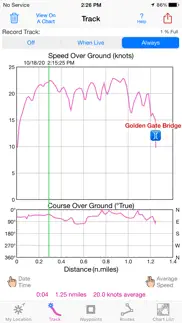
Version 9.2.005 February 2021I'm continually improving this app so it will be even more useful! In this version, the Track screen now shows a graph of the Course (COG) as well as the Speed (SOG).
What's new in iSailGPS when compared with other available NOAA chart apps?
• You don't just see waypoints and routes displayed on the chart, you can actually do real great circle navigation to those waypoints and along those routes. You get information such as Estimated Time of Arrival, current bearing and heading, and remaining distance to your intermediate and final destinations.
• You don't just see individual charts. Whenever the map projection is compatible (which it is most cases), you can see adjacent charts with their margins removed stitched together seamlessly, even when the chart scales are different. For example you can see the approach chart and the corresponding harbor detail chart both together on the same screen.
• You can create, import, edit, export, and navigate both on routes based on a recorded or imported path, and on routes based on a series of waypoints.
• iSailGPS' s code size is kept very small by efficient programming so in an emergency, you can download it easily even over a weak cell connection..
Version 9.1.122 November 2020I'm continually improving this app so it will be even more useful! This version changes the background color of the Estimated Time of Arrival according to the sun's position to warn you if you will be arriving after the sun sets at your destination. Updated for the iPhone 12.
What's new in iSailGPS when compared with other available NOAA chart apps?
• You don't just see waypoints and routes displayed on the chart, you can actually do real great circle navigation to those waypoints and along those routes. You get information such as Estimated Time of Arrival, current bearing and heading, and remaining distance to your intermediate and final destinations.
• You don't just see individual charts. Whenever the map projection is compatible (which it is most cases), you can see adjacent charts with their margins removed stitched together seamlessly, even when the chart scales are different. For example you can see the approach chart and the corresponding harbor detail chart both together on the same screen.
• You can create, import, edit, export, and navigate both on routes based on a recorded or imported path, and on routes based on a series of waypoints.
• iSailGPS' s code size is kept very small by efficient programming so in an emergency, you can download it easily even over a weak cell connection..