

- 11.0LEGITIMACY SCORE
- 15.5SAFETY SCORE
- 4+CONTENT RATING
- $1.99PRICE
What is ISailGPS NZ : NZ Marine Charts? Description of ISailGPS NZ : NZ Marine Charts 3997 chars
Unleash the navigation potential of your iPhone or iPad with SailGPS NZ! Turn your device into a high-performance GPS receiver with LINZ RNC Nautical Charts, even without a cell signal!
Caught in a storm on the water and your chart plotter fails? Don't worry! Download this app now and regain navigation capabilities to safely return to port. Better yet, buy iSailGPS NZ today ensuring you're prepared for any situation, even in areas with no cell service.
iSailGPS NZ has no sign-ups, ads, subscriptions or in-app purchases, making it more affordable, hassle-free & respectful of your privacy.
Unrivaled Features to Enhance Your Journey:
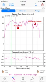
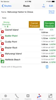
TRACKS, WAYPOINTS & ROUTES
Record tracks as you sail, even in the background. View them on the chart and in a Speed & Course Over Ground graph.
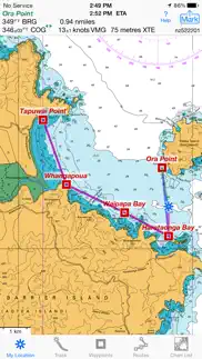
Mark waypoints precisely using topo or satellite maps, place names or addresses, geotagged photos, or by projecting from a known point.
Set a quick GoTo waypoint or a full route and see the course (COG), heading (HDG), bearing (BRG), direction, distance, cross track error (XTE), Velocity Made Good (VMG) and Estimated Time of Arrival (ETA) at your destination and intermediate points. Perfect for racing enthusiasts.
In a Man Overboard (MOB) emergency a single button press marks your current position & starts navigating to it.
Create customized routes using waypoints, recorded tracks, or imported GPX, KML or TCX files. Advanced route editing.
Send GPX and KML waypoint, route, track and map list files via AirDrop, eMail, Messages, or iCloud Drive.
View the sun & moon position, rise times & set times for any date and place on earth.
Send data to other apps such as Google Earth.
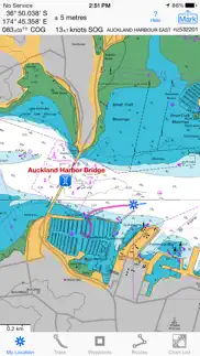
LAND INFORMATION NEW ZEALAND MARINE CHARTS
Access all LINZ NZ Raster Nautical Charts updated as of 7/12/23 with no extra charge. Download using WiFi or cell service.
Our charts are optimized to download faster & use less storage memory. Store a few charts or charts for the whole country to use anytime without cell service.
Stitches Mercator charts & automatically switches between downloaded charts as you sail. Choose detailed or overview charts.
Enjoy the high resolution and what's-all-around detail of these NZ Nautical Charts (RNC). They are a welcome advantage over Vector Charts, which only show a coastline, depths, navigation aids, and minimal details.
Print and Share chart images overlaid with waypoints, routes & tracks.
Measure distance between any two points.
USE THE UNITS YOU PREFER
Kilometers, Miles, or Nautical Miles.
Meters or Feet.
Degrees, Degrees/Minutes, Degrees/Minutes/Seconds, UTM, or NZTM2000 grid.
°True or °Magnetic.
HOW TOS
Tap Help in the app.
Online Manual: iSailGPS.com/nz
Email developer: [email protected]
RASTER CHARTS VS. VECTOR CHARTS
The Land Information New Zealand raster nautical charts in iSailGPS NZ differ from computer-drawn vector charts in that each chart covers a specific area, the same way a paper nautical chart does. Switches automatically to a new chart when you leave the area covered by the previous chart. For many locations, there are multiple charts at different scales with different levels of detail & areas of coverage.
Paper charts can contain multiple panels, each showing a different area or scale. Each digital panel is individually displayed by iSailGPS NZ with a north-up orientation.
iSail GPS NZ is priced to make it readily available to all boating enthusiasts.
iSailGPS NZ and the charts that it includes do NOT meet the legal requirements for navigation using charts that you may be required to carry.
DEVICE REQUIREMENTS
Use iSailGPS on any iOS device even if you don't have a cellular data plan for it. iPhones & WiFi+cellular iPads support all features. For WiFi-only iPads & iPod touch, an iOS-compatible external GPS receiver is required to show your location & record tracks. However, you can view charts using the iOS device alone.
Discover a safer and more enjoyable sailing experience with iSailGPS NZ!
- ISailGPS NZ : NZ Marine Charts App User Reviews
- ISailGPS NZ : NZ Marine Charts Pros
- ISailGPS NZ : NZ Marine Charts Cons
- Is ISailGPS NZ : NZ Marine Charts legit?
- Should I download ISailGPS NZ : NZ Marine Charts?
- ISailGPS NZ : NZ Marine Charts Screenshots
- Product details of ISailGPS NZ : NZ Marine Charts
ISailGPS NZ : NZ Marine Charts App User Reviews
What do you think about ISailGPS NZ : NZ Marine Charts app? Ask the appsupports.co community a question about ISailGPS NZ : NZ Marine Charts!
Please wait! Facebook ISailGPS NZ : NZ Marine Charts app comments loading...
ISailGPS NZ : NZ Marine Charts Pros
✓ Great product, awesome priceThis app uses the official NZ Marine charts which look exactly like the paper charts because they are accurate LINZ scans, this is my preference as we usually have the paper chart on hand as well. The app is easy to learn and use so very happy. I also have used MacGPS Pro for 6 years with a laptop and that has been great as well. Two items of software from an excellent customer focused company. You can even email the company founder Larry James direct and expect to get a prompt reply!.Version: 6.1
✓ Awesome app to map fishing spotsI was looking for an app to map a bundle of GPS coordinates id been given for fishing spots and this App was ideal. highly recommend.Version: 9.0.0
✓ ISailGPS NZ : NZ Marine Charts Positive ReviewsISailGPS NZ : NZ Marine Charts Cons
✗ It’s rubbishDon’t waste your money! It is not intuitive and there are far better nav apps available It would be nice to have a trial option before purchasing - or did I miss it?.Version: 9.3.2
✗ Don’t use itThis map is not clear , don’t waste your money loading this . Not very good.Version: 9.3.3
✗ ISailGPS NZ : NZ Marine Charts Negative ReviewsIs ISailGPS NZ : NZ Marine Charts legit?
ISailGPS NZ : NZ Marine Charts scam ~ legit report is not ready. Please check back later.
Is ISailGPS NZ : NZ Marine Charts safe?
ISailGPS NZ : NZ Marine Charts safe report is not ready. Please check back later.
Should I download ISailGPS NZ : NZ Marine Charts?
ISailGPS NZ : NZ Marine Charts download report is not ready. Please check back later.
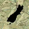
ISailGPS NZ : NZ Marine Charts Screenshots
Product details of ISailGPS NZ : NZ Marine Charts
- App Name:
- ISailGPS NZ : NZ Marine Charts
- App Version:
- 9.4.5
- Developer:
- James Associates Inc.
- Legitimacy Score:
- 11.0/100
- Safety Score:
- 15.5/100
- Content Rating:
- 4+ Contains no objectionable material!
- Category:
- Navigation, Travel
- Language:
- EN
- App Size:
- 9.08 MB
- Price:
- $1.99
- Bundle Id:
- com.macgpspro.iSailGPS-NZ
- Relase Date:
- 14 September 2014, Sunday
- Last Update:
- 07 March 2024, Thursday - 07:35
- Compatibility:
- IOS 12.0 or later
I'm continually improving this app so it will be even more useful! This version adds the ability to view a weather report for any location. What's new in iSailGPS NZ when compared with other available New Zealand chart apps? You don't just see way....