
- 17.0LEGITIMACY SCORE
- 18.5SAFETY SCORE
- 4+CONTENT RATING
- $1.99PRICE
What is Hoge Veluwe National Park GPS and outdoor map? Description of Hoge Veluwe National Park GPS and outdoor map 3991 chars
■ “Download any FlytoMap application for Free! By purchasing FlytoMap All-in-One App.”
■ !! Watch "FlyToMap GPS" app video on www.appreview.com and www.youtube.com !!
[Version: 2.5 - Topo]
► New Design - Exclusively for the iPhone 3.0: FlyToMap multi-dimensional charts OVERLAYED with Satellite photos and map features.
► The unique application on App Store with this cutting edge technology.
► New iPhone 3GS Magnetic Compass integration.
--------------------------------------------------------------------------------------------------------------------------
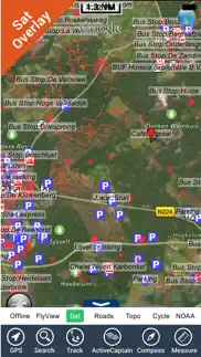
- PARK MAPS:
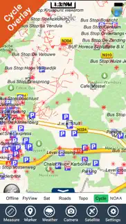
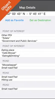
Park maps are extremely advanced embedded electronic charts with all information collected from the National/State Park and Forest Services and many other local sources. The maps contain all trails (Hiking, Biking, Equestrian trails etc.,) and Points of interests (POI) like Campgrounds, Visitor Centers, Lookout points, Eating places, Ranger Stations, Picnic areas, Boat/Canoe ramps, Parking areas etc. and much more:
“all Trails, Lakes and Rivers within the Parks”
“Park boundary”
“Elevation Contours with 10 meters step” (only "Topo" version)
“Mountain Peaks”
“All Roads and Railways”
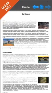
...and full Travel Guide with photos, maps, history, not to miss places.....
--------------------------------------------------------------------------------------------------------------------------
How to use:
“Zoom and Pan fast just by a finger touch”
“Use Latitudes and Longitudes to go to your favorite places”
"Record your GPS Track"
“Detailed touristic guide at your finger's disposal”
“Navigate and see your GPS position on the map”
“Geo-Tagged photo management”
“Insert the target/destination ‘Waypoint’ and see in real time your speed, distance and direction to destination”
“Insert Unlimited Markers near favorite places on the map”
“Search your Favorite points or any location by name”
“Set On/Off Elevation Contours if you feel data is cluttering”
- WATER MAPS (Marine):
The new ‘iPhone Marine Navigator’: it contains embedded Electronic Nautical Charts (ENC) from NOAA and Corps of Engineers compressed to store the largest coverage. You can transform your iPhone in a chart plotter with best NOAA-USACE, ENC S57 cartography; which includes Coastline, Anchoring areas, Fishing areas, Restriction areas, Obstructions, Rocks, Buoys, Beacons, Lights, Depth contours (with values displayed in real time on map), Spot Soundings and more. Every effort is made to be as accurate as possible when presenting information for every sea area.
- LAKE MAPS:
High quality lake maps with detailed information and important features compressed to assure the larger coverage. Lake maps contain the most important lakes with detailed Depth Contours, Boat Ramps, Fishing spots etc. Maps also include Trails, Roads and Railways information.
- TRAVEL MAPS:
These Maps cover most interesting touristic areas combining Sea and Land information to allow you a complete travel experience. These are the best Maps to travel on fascinating voyages; map focus on the best Beach spots along the Coastline, Major ports, Sailing, Fishing, Picnic areas, Parks, Hiking, Biking, Clubs, Restaurants, Famous Hotels, Museums, Shopping areas, and much more.
A Travel Guide with photos, maps, history, not to miss places..... is included.
- HUNT MAPS:
These maps are designed specifically for hunting activities.
They contain the best hunting maps of the area with all the information for a safety and unforgettable hunting experience.
These maps are including all Parks, Forests, Trails, Huts, WMA (Wildlife Management Areas), Refuges, Point of Interests, etc. and a complete topographic map (Elevation contours, lakes, rivers, streams, roads, etc.).
A complete Hunting Guide with information about Season, Limits, Licensing, restrictions, etc.......is included.
"Continued use of GPS running in the background can dramatically decrease battery life."
- Hoge Veluwe National Park GPS and outdoor map App User Reviews
- Hoge Veluwe National Park GPS and outdoor map Pros
- Hoge Veluwe National Park GPS and outdoor map Cons
- Is Hoge Veluwe National Park GPS and outdoor map legit?
- Should I download Hoge Veluwe National Park GPS and outdoor map?
- Hoge Veluwe National Park GPS and outdoor map Screenshots
- Product details of Hoge Veluwe National Park GPS and outdoor map
Hoge Veluwe National Park GPS and outdoor map App User Reviews
What do you think about Hoge Veluwe National Park GPS and outdoor map app? Ask the appsupports.co community a question about Hoge Veluwe National Park GPS and outdoor map!
Please wait! Facebook Hoge Veluwe National Park GPS and outdoor map app comments loading...
Hoge Veluwe National Park GPS and outdoor map Pros
The pros of the Hoge Veluwe National Park GPS and outdoor map application were not found.
✓ Hoge Veluwe National Park GPS and outdoor map Positive ReviewsHoge Veluwe National Park GPS and outdoor map Cons
The cons of the Hoge Veluwe National Park GPS and outdoor map application were not found.
✗ Hoge Veluwe National Park GPS and outdoor map Negative ReviewsIs Hoge Veluwe National Park GPS and outdoor map legit?
Hoge Veluwe National Park GPS and outdoor map scam ~ legit report is not ready. Please check back later.
Is Hoge Veluwe National Park GPS and outdoor map safe?
Hoge Veluwe National Park GPS and outdoor map safe report is not ready. Please check back later.
Should I download Hoge Veluwe National Park GPS and outdoor map?
Hoge Veluwe National Park GPS and outdoor map download report is not ready. Please check back later.
Hoge Veluwe National Park GPS and outdoor map Screenshots
Product details of Hoge Veluwe National Park GPS and outdoor map
- App Name:
- Hoge Veluwe National Park GPS and outdoor map
- App Version:
- 5.5
- Developer:
- Flytomap
- Legitimacy Score:
- 17.0/100
- Safety Score:
- 18.5/100
- Content Rating:
- 4+ Contains no objectionable material!
- Category:
- Travel, Navigation
- Language:
- EN FR IT ES
- App Size:
- 19.85 MB
- Price:
- $1.99
- Bundle Id:
- com.flytomap.PMDeHgeVeluwePark
- Relase Date:
- 01 February 2016, Monday
- Last Update:
- 04 August 2017, Friday - 19:01
- Compatibility:
- IOS 9.0 or later
This app has been updated by Apple to display the Apple Watch app icon. Track improvement Marine Weather algorithm update.