- 19.0LEGITIMACY SCORE
- 19.5SAFETY SCORE
- 4+CONTENT RATING
- FreePRICE
What is I-Boating : Marine Navigation? Description of I-Boating : Marine Navigation 4099 chars
This App offers access to Marine Charts for USA,Canada,UK/Ireland,Germany,Netherlands/Holland &
Europe Rivers (Danube,Drava,Rhein etc). Coverage includes NOAA marine vector charts,freshwater lake maps,USACE inland river maps (HD/1ft/3ft bathymetry included where available),charts derived from UKHO & CHS data. First marine GPS app to have route assistance for marine navigation. You can create new boating routes or import existing GPX/KML routes. It supports Nautical Charts course up orientation.
►FEATURES
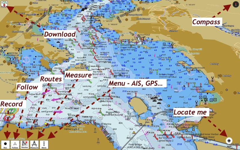
√ Beautiful & detailed Hardware/GPU accelerated vector charts (text stays upright on rotation)
√ Long press to query the details of Marine object (Buoy,Lights,Obstruction etc).
√ Customizable depth(Ft/Fathom/Meter) & distance units(km/mi/NM)
√ Customizable Shallow Depth.
√ Record tracks,Autofollow with real-time track overlay & predicted path vector.
√ Route Assistance for marine navigation (requires GPS )
√ 1ft / 3ft depth contour maps for anglers for selected lake maps.
√ Supports GPX/KML for boating route editing/import.
√ Seamless chart quilting of marine charts
√ Enter or import Waypoints.
► GPS
√ Most USB, Bluetooth and external receivers with SPP profile are supported.
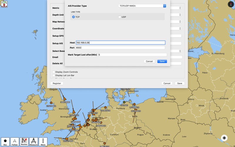
► Instrumentation & AIS
√ Marine Ais & (NMEA AIS and GPS over TCP/UDP).
√ Wind direction & Speed, marine sonar depth, water temperature
► Fishing Hot Spots AI
► Lake Temperature Maps(Thermoclines accurate to 1°F (0.5° C)
► MAPS
It includes unlimited updates for 1 year.
√USA: The maps include coverage of all NOAA marine vector charts (ENC),USACE inland river maps,freshwater lake maps for more than 7K lakes. The charts include HD/1ft/3ft bathymetry where available.Incl. NOAA raster where ENC not available.
√Canada:Incl. CHS data(incl. major Lakes).
√UK/Ireland: Derived from UKHO charts.
√Australia
√Germany: All BSH Charts.
√Europe Inland Rivers:Donau/Dunaja,Rhine,Garonne,Moselle,Drava,Sava,etc
√Norway
√Finland
√Sweden
√Croatia
√Ukraine(Black Sea)
√Caribbean
√New Zealand
√Spain
√Brazil
√Argentina
√Cyprus
√Falklands
√Seychelles& Mauritius
√Denmark
√Malta,Cyprus & S. Mediterranean
√S. China&Malaysia
√South Africa
►ROUTE MANAGEMENT / TRIP PLANNING
√ Create New Route/Edit Existing Routes
√ Move Points
√ Add points to an existing route leg
√ Delete / Rename points
√ Import GPX,KML & KMZ files
√ Plot/Edit Routes
√ Enter Waypoints
√ Share/Export Routes,Tracks&Markers
√ Reverse Routes
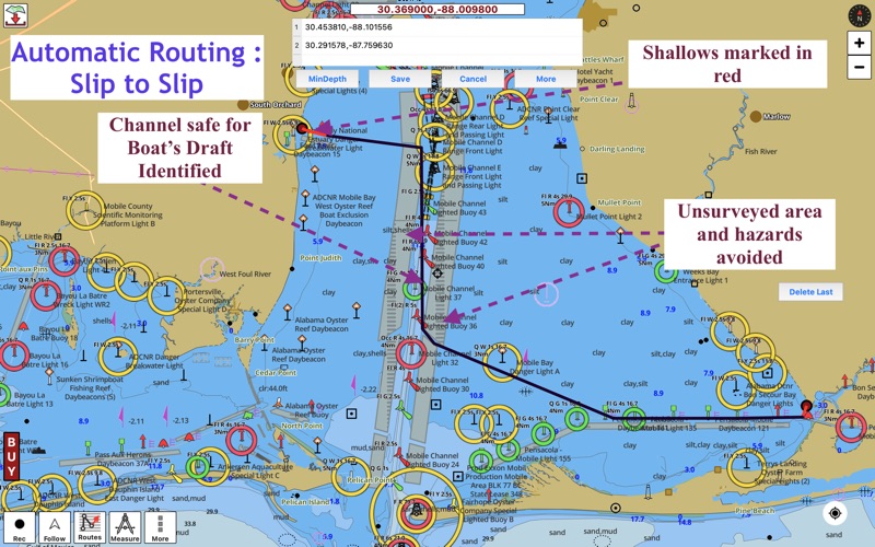
►AUTOMATIC ROUTING SLIP TO SLIP
√ Safe for Boat's Draft
√ Avoid Hazards
√ Optimized for Fuel, Distance, Time
►GPS FEATURES
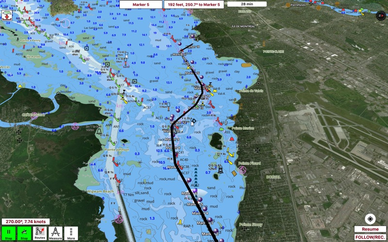
√ Auto Follow
* Real Time Track Overlay
* Predicted Path Vector
* Course Up(Text stays upright)
* Speed & Heading
√ Route Assistance With Voice Prompts
* Prompts when approaching a boating route marker
* Continous distance & ETA updates
* Alerts when sailing/boating off route
* Alerts when boating in wrong direction
√ Record Tracks
► SHARING
* Share tracks/routes/markers on Facebook & Twitter
* Export tracks/routes/markers as compressed GPX files.
Sample Charts
SUGARLOAF KEY-KEY WEST
PORT RICHEY TAMPA BAY - CLEARWATER HBR
EAST BAY-WEST BAY FLORIDA
ST JOSEPH,ST ANDREW BAYS
INTRACOASTAL WATERWAY MATECUMBE-GRASSY KEY
CHESAPEAKE BAY CAPE CHARLES-NORFOLK HARBOR
ANCLOTE KEYS-CRYSTAL RIVER
ST JOSEPH SOUND
MIAMI HARBOR
Minnesota lakes - Kabetogama,Minnetonka,Waconia,Leech,Mille Lacs
Lake Keowee,Jocassee,Hartwell,Greenwood,Lake Murray
Mark Twain,Ozarks,Table Rock
Lake St.Clair
Lake Kentucky
KEY WEST-THE MISSISSIPPI RIVER
SAN PEDRO CHANNEL
LAKE MICHIGAN STONY LAKE-POINT BETSIE
APALACHICOLA BAY-CAPE SAN BLAS
CHESAPEAKE BAY CAPE HENRY-THIMBLE SHOAL LIGHT
DULUTH-SUPERIOR
ONTARIO
Winnipesaukee
MIAMI-MARATHON,FLORIDA BAY
CAPE MAY-FENWICK ISLAND
MISSISSIPPI RIVER-GALVESTON
CAPE CANAVERAL-KEY WEST
DELAWARE RIVER WILMINGTON-PHILADELPHIA
FLORIDA KEYS SOMBRERO KEY-SAND KEY
SAN PABLO BAY
RAINY LAKE BIG ISLAND MINN
INTRACOASTAL WATERWAY - BISCAYNE BAY
EVERGLADES NTL PARK - SHARK RVR-LOSTMANS
HURON
TAHOE
CHESAPEAKE DELAWARE CANAL
- I-Boating : Marine Navigation App User Reviews
- I-Boating : Marine Navigation Pros
- I-Boating : Marine Navigation Cons
- Is I-Boating : Marine Navigation legit?
- Should I download I-Boating : Marine Navigation?
- I-Boating : Marine Navigation Screenshots
- Product details of I-Boating : Marine Navigation
I-Boating : Marine Navigation App User Reviews
What do you think about I-Boating : Marine Navigation app? Ask the appsupports.co community a question about I-Boating : Marine Navigation!
Please wait! Facebook I-Boating : Marine Navigation app comments loading...
I-Boating : Marine Navigation Pros
The pros of the I-Boating : Marine Navigation application were not found.
✓ I-Boating : Marine Navigation Positive ReviewsI-Boating : Marine Navigation Cons
✗ Installed into 10.13, does not run.Looking for a maring navigation planning software. Found it in the App store, downloaded it and it does not run on 10.13.6 High Sierra MacBook Pro 2015. 2.5 ghz i7. Cannot say more....Version: 102.0.0
✗ Kinda bad..Downloaded this to see if it would work with other nav softwear i have. when i export a file it does not send it as a gpx file, it sends it as a gpxgx file which obviousley wont open on any other softwear/gps. Other issue is poor layout of the app, could be a lot better. BIGGEST gripe is this not being avaiable for ANY macbook, macbook air or Imac WITHOUT a M1 chip. this is the sole reason i wont pay for this app..Version: 116.0.0
✗ I-Boating : Marine Navigation Negative ReviewsIs I-Boating : Marine Navigation legit?
I-Boating : Marine Navigation scam ~ legit report is not ready. Please check back later.
Is I-Boating : Marine Navigation safe?
I-Boating : Marine Navigation safe report is not ready. Please check back later.
Should I download I-Boating : Marine Navigation?
I-Boating : Marine Navigation download report is not ready. Please check back later.
I-Boating : Marine Navigation Screenshots
Product details of I-Boating : Marine Navigation
- App Name:
- I-Boating : Marine Navigation
- App Version:
- 142.0.0
- Developer:
- Bist LLC
- Legitimacy Score:
- 19.0/100
- Safety Score:
- 19.5/100
- Content Rating:
- 4+ Contains no objectionable material!
- Language:
- EN
- App Size:
- 26.75 MB
- Price:
- Free
- Bundle Id:
- com.skiracer.gpsnauticalchartsmacc
- Relase Date:
- 25 October 2019, Friday
- Last Update:
- 18 January 2024, Thursday - 22:53
- Compatibility:
- IOS 10.12.0 or later
Major Update: Lake Temperature Maps: Identify Fishing Hot Spots using Thermoclines accurate to 1°F (0.5° C)..